
Rotenfels
| Rotenfels | ||
|---|---|---|
 The Traiser Rotenfels |
||
| height | 327 m above sea level NHN | |
| location | Traisen , Rhineland-Palatinate , Germany | |
| Coordinates | 49 ° 49 '1 " N , 7 ° 50' 11" E | |
|
||
| rock | Rhyolite | |

The Rotenfels ( 327 m above sea level ) is a mountain in the area of the local community Traisen , between Bad Münster am Stein-Ebernburg , Norheim in the west and Rüdesheim in the north. It is a nature reserve and a destination for experienced climbers.
geography
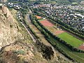
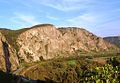
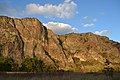
The mountain with a gentle plateau takes its name from the striking reddish south-west face with which it falls to the Nahe . The wall line is 1200 m long and 202 m high, it is considered the highest rock face between the Alps and Scandinavia . Most of the Rotenfels lies in the area of the municipality of Traisen . Below the Rotenfels to close extend the national road 235 and a two-track railway line ( KBS 680 / close Talbahn ). The Traiser Bastei vineyard is located there . The Traiser Rotenfels location is west of the steep slope.
geology
The rock massif consists of reddish rhyolite , a quartz porphyry rock with a fine-grain, crystalline structure. 270 to 260 million years ago, in a phase of particularly brisk volcanic activity , the reddish rock of the Rotenfels, which was very weather-resistant after its solidification , was formed by molten, rising magma . Hydrothermally decomposed zones can be recognized by their lighter color. There the feldspars are converted into kaolin . The Nahe has milled this rock structure as a steep bank into the rock over thousands of years and removed a large part of the weathering debris.

Rotenfels nature reserve
In terms of its fauna (birds of prey) and rich flora, the Rotenfels is a unique biotope in a wide area. H. 1939, placed under nature protection by the Koblenz district government . In 1998, the district government issued a statutory ordinance that laid down additional provisions on the nature reserve.
The protective purpose is the preservation and development of the mountain range with its rocky areas
- as a location for rare plants and plant communities whose existence is threatened,
- as a habitat for endangered animals,
- because of its geological nature as well
- for scientific and cultural reasons.
The nature reserve has a size of 91 ha. There are therefore restrictions for climbing in the area of the massif.
Climbing on the Rotenfels
In contrast to so-called "Plaisirkletterrouten", which are well secured and have little objective dangers, the routes on Rotenfels are sometimes extremely dangerous because the wall is mainly composed of mostly wedge-shaped, nested blocks, which often break when subjected to tensile loads. Although there are now cemented standing hooks in some routes and bolts in some key points, intermediate securing devices are difficult to attach due to the loose surface structure. The Rotenfels is therefore not a sport climbing area, but has a serious alpine character and is only suitable for experienced climbers. In addition, a good knowledge of the area is necessary in order to orientate oneself in the multitude of gutters, chimneys, towers, quarry walls and steep slopes. An additional difficulty is that the weathering product of the fractured rock is an excellent breeding ground for plants, so that the wall looks like a green meadow when viewed from above during the growing season. The Alpine Association recommends non-residents to be guided by someone who knows the area.
You can get to the climbing routes by descending without ropes from the plateau or (less often) climbing (up to difficulty level 3) over mostly gravel-filled, steep gullies and chimneys. For the routes up to the 7th grade, between three and five pitches, you need up to 3 hours. Abseiling is problematic as the rope is easily caught on the many prongs.
As an important rock biotope and nature reserve, the rock face is subject to strict climbing restrictions. To protect the peregrine falcons , climbing in the wall section west of the bastion is therefore prohibited all year round, east of the bastion from January 1st to June 30th. Exceptions for clearances for climbing within the regular blocking period will usually be announced at the end of April / beginning of May.
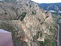
View from the bastion of Rotenfels
View from the bastion of Rotenfels
The Traisener Rotenfels

The Rotenfels vineyard in April

View from the Nahe from the southwest

Side view of the Rotenfels with bastion

Rotenfels - view from the Ebernburg
View from Bad Munster am Stein-Ebernburg

View from the Friedensbrücke to the Nahe and Rotenfels


See also
Web links
- Geology of the Nahe valley on maasberg.ch
- Winfried Schenk: Expert opinion on potential world heritage sites in the Nahe region. January 15, 2020, accessed April 25, 2020 .
Individual evidence
- ↑ Query of the course book route 680 at Deutsche Bahn.
- ^ Ordinance on the "Rotenfels" nature reserve of September 5, 1939
- ↑ Ordinance on the "Rotenfels" nature reserve of October 30, 1998 (PDF; 107 kB)
- ^ German Alpine Association, Nahegau section: Climbing in the Rotenfels. Retrieved May 1, 2018 .

At the pit head | At the Hartmannsgalgen | At the birdsong | Meadows | Disibodenberg | Flachsberg | Goose and Rheingrafenstein | Glashütte meadows | Göttelsteiner rocks | Hellberg near Kirn | Hellersberger Weiher | Shepherd's meadow in Lützelsoon | In the ash tree | In Graefenbrühl | In the forest corner | Bad Kreuznach spa gardens | Rural meadows | Maasberg | Nightingale Valley | Nahegau | Nahe valley from Boos to Niederhausen | Lviv | New Bamberg Heath | Raven head | Ringberg | Rotenfels | Saukopf and Fichtekopf | Sponheimer Lettkaut | Stromberg | Trübenbachtal | Lower Nahe | Wingertsberg