
Imsweiler
| coat of arms | Germany map | |
|---|---|---|

|
Coordinates: 49 ° 36 ' N , 7 ° 48' E |
|
| Basic data | ||
| State : | Rhineland-Palatinate | |
| County : | Donnersbergkreis | |
| Association municipality : | North Palatinate Country | |
| Height : | 312 m above sea level NHN | |
| Area : | 9.9 km 2 | |
| Residents: | 532 (Dec. 31, 2019) | |
| Population density : | 54 inhabitants per km 2 | |
| Postal code : | 67808 | |
| Primaries : | 06361, 06363 | |
| License plate : | KIB, ROK | |
| Community key : | 07 3 33 034 | |
| Community structure: | 3 districts | |
| Association administration address: | Bezirksamtsstrasse 7 67806 Rockenhausen |
|
| Website : | ||
| Local Mayor : | Peter Ziepser | |
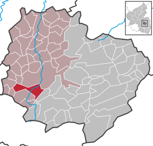
| Location of the local community Imsweiler in the Donnersbergkreis | ||
  |
||

Imsweiler is a municipality in the Donnersbergkreis in Rhineland-Palatinate . It belongs to the Nordpfälzer Land association.
geography
The place is located in the North Palatinate Uplands west of the Donnersberg between Kaiserslautern and Bad Kreuznach .
The community consists of the village of Imsweiler, the two hamlets Felsbergerhof and Spreiterhof and the Schleifmühle residential area .
Spreiterhof is a hamlet that consists of ten houses with around 30 inhabitants . There is also a farm in Spreiterhof . The residents of Spreiterhof and Felsbergerhof belong to the parish of Dörrmoschel under parish law .
history
Imsweiler was first mentioned as "Imziswilre" in 1112 and as "Imiciswilare" (= hamlet of Imizin) in 1127. The name suggests a Franconian foundation in the 7th or 8th century.
Imsweiler Castle
The history of the place is closely linked to the history of the former moated castle in the place, the remains of which are now privately owned.
A castle is mentioned for the first time in a document from 1242, which was given to Countess Ermesindis von Lützelburg by the Lords of Bolanden as a fief. However, it was the Mühlberg Castle on the nearby mountain of the same name.
Only in a document dated January 31, 1333 is the castle in Imsweiler explicitly mentioned as a Hornbach fief to Raugraf Heinrich II, Lord of Neuenbaumburg .
The descendants resided until 1415, most recently Raugraf Philipp von Altenbaumburg , who passed the castle to Count Palatine Ludwig III. sold. After the Elector of the Palatinate, the castle became the fief of various nobles. In 1550 there is a report of an ownership dispute between Carl von Lewenstein, the son of Johann Brenner von Lewenstein, who was buried in the Catholic Church, and Hans Jakob von Dhun. In the middle of the 16th century the castle was probably partially destroyed, because in 1595 the knight Philip Jakob von Flersheim , married to Maria Vogtin von Hunoltstein , built a castle on the ruins and invested 4,000 guilders in the process. Your coat of arms can still be seen in the lintel today. When the Flörsheim family died out and the property was also devastated by the Thirty Years War, Hermann Schellenschmidt from Mannweiler took over the estate in 1655 and built a house out of the rubble. In 1720 one of the hereditary estates built the courtyard and farm buildings.
politics
Municipal council
The municipal council in Imsweiler consists of twelve council members, who were elected in the local elections on May 26, 2019 in a personalized proportional representation, and the honorary local mayor as chairman. The twelve seats in the municipal council are divided between two groups of voters .
Local mayor
Local mayor is Peter Ziepser. In the local elections on May 26, 2019, he was re-elected in office with 86.60% of the vote.
coat of arms
|
|
Blazon : "In silver, a blue St. Andrew's cross topped by two red roses with gold inserts." |
Culture and sights
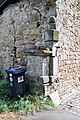
The palace or courtyard house (as it is called today) came into private ownership after the French occupation. An underground, brick corridor led from the vaulted cellar of the main building to the tower of the Catholic Church. It was probably an escape route into the nearby forest. Today the corridor is walled up. In the building on the left, the windows adorned with the coat of arms with the year 1595 are still preserved. It also houses a stone pillar and a draw well.
There is also a bread museum in the former castle mill between Alsenz and the Mühlwald.
The parish church of St. Petrus in Ketten was built in the 11th century. In 1896 the parish church was enlarged and in 1899 it was consecrated . It contains the double epitaph of Johann Brenner von Löwenstein († 1521), Burgrave of the Electorate of Palatinate in Alzey and his wife Apollonia born. von Heppenheim called from the hall . They are the parents of the Speyer cathedral cantor and vicar general Johannes Brenner von Löwenstein († 1537).
On the Mühlberg there are remains of the lost Mühlberg Castle .
See also: List of cultural monuments in Imsweiler
- Picture gallery

Protestant bell tower

Protestant bell tower entrance

Catholic parish church

Catholic parish church stone cross

former schoolhouse

former teacher's apartments

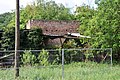
Village mill
Pedestal of the castle
Wall remains


Economy and Infrastructure
The community has its own elementary school, the Paula Best School .
Secondary schools are located in Rockenhausen ( comprehensive school , secondary school , vocational school , school for people with learning disabilities) and Winnweiler ( grammar school ). The responsible kindergarten is in Gundersweiler .
The B 48 runs through the village . There is a connection to long-distance traffic via the Winnweiler junction of the A 63 in the southeast.
Imsweiler (meanwhile again) has a stop on the Alsenz Valley Railway .
There is a launch site for microlight aircraft above the village .
Web links
- Local community Imsweiler on the website of the Rockenhausen Association
- Literature about Imsweiler in the Rhineland-Palatinate state bibliography
Individual evidence
- ↑ State Statistical Office of Rhineland-Palatinate - population status 2019, districts, communities, association communities ( help on this ).
- ↑ State Statistical Office Rhineland-Palatinate (ed.): Official directory of the municipalities and parts of the municipality. Status: January 2019 [ Version 2020 is available. ] . S. 143 (PDF; 3 MB).
- ↑ Jürgen Keddigkeit, Michael Losse: Palatinate Burgenlexikon III IN. Kaiserslautern 2005, ISBN 3-927754-51-4 , pp. 55-64.
- ^ The Regional Returning Officer Rhineland-Palatinate: City Council Election 2019 Imsweiler. Retrieved August 25, 2019 .
- ^ The State Returning Officer Rhineland-Palatinate: direct elections 2019. see Nordpfälzer Land, Verbandsgemeinde, twelfth line of results. Retrieved August 25, 2019 .
- ^ Genealogical website about the couple
- ↑ Laura Jung: Lord of the Knights. Monument commemorates the burgrave Johann Brenner von Loewenstein. (No longer available online.) In: Allgemeine Zeitung Alzey. April 9, 2014, archived from the original on January 26, 2015 ; accessed on October 19, 2019 .

Albisheim (Pfrimm) | Alsenz | Bayerfeld-Steckweiler | Bennhausen | Biedesheim | Bischheim | Bistiffer | Bolanden | Börrstadt | Breunigweiler | Bubenheim | Dannenfels | Dielkirchen | Dried mussel | Dreisen | Solitude | Eisenberg (Palatinate) | Falkenstein | Finkenbach-Gersweiler | Gauersheim | Gaugrehweiler | Gehrweiler | Gerbach | Göllheim | Gonbach | Gundersweiler | Höringen | Ilbesheim | Immesheim | Imsbach | Imsweiler | Jakobsweiler | Lime kiln | Katzenbach | Candle Home | Kirchheimbolanden | War field | Lautersheim | Pay field | Mannweiler-Cölln | Marnheim | Morschheim | Mörsfeld | Münchweiler an der Alsenz | Münsterappel | Niederhausen an der Appel | Niedermoschel | Oberhausen an der Appel | Upper Muschel | Oberndorf | Oberwiesen | Orbis | Ottersheim | Ramsen | Ransweiler | Rathskirchen | Reichsthal | Rittersheim | Rockenhausen | Ruppertsecken | Rüssingen | Saint Alban | Schiersfeld | Schönborn | Schweisweiler | Souls | Sippersfeld | Sitters | Stahlberg | Standenbühl | Steinbach am Donnersberg | Stetten | Teschenmoschel | Unkenbach | Waldgrehweiler | Wartenberg-Rohrbach | Weitersweiler | Winnweiler | Winterborn | Würzweiler | Zellertal