
Gaugrehweiler
| coat of arms | Germany map | |
|---|---|---|

|
Coordinates: 49 ° 42 ' N , 7 ° 52' E |
|
| Basic data | ||
| State : | Rhineland-Palatinate | |
| County : | Donnersbergkreis | |
| Association municipality : | North Palatinate Country | |
| Height : | 227 m above sea level NHN | |
| Area : | 9.92 km 2 | |
| Residents: | 537 (Dec. 31, 2019) | |
| Population density : | 54 inhabitants per km 2 | |
| Postal code : | 67822 | |
| Area code : | 06362 | |
| License plate : | KIB, ROK | |
| Community key : | 07 3 33 023 | |
| Association administration address: | Schulstrasse 16 67821 Alsenz |
|
| Website : | ||
| Mayoress : | Romy Heblich | |
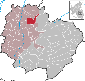
| Location of the local community Gaugrehweiler in the Donnersbergkreis | ||
  |
||


Gaugrehweiler is a municipality in the Donnersbergkreis in Rhineland-Palatinate . It belongs to the Nordpfälzer Land association.
geography
location
The community is located in the Münstertal in the North Palatinate Uplands , between Kaiserslautern and Bad Kreuznach . Gaugrehweiler also includes the Gutenbacherhof and Leiningerhof residential areas .
Waters
The Appelbach , alternatively called "the Appel", flows through Gaugrehweiler . The Gutenbach runs through the east of the district and takes the Engelsbach from the right .
history
Since 1401 Gaugrehweiler next 30 Furthermore, parishes for the first time as part of the country chapter Münsterappel of Mainz Archdiocese mentioned.
Since the 15th century, a Grehweiler in the Appel and in the Moscheltal has been distinguished by the fact that the former is characterized as being in the Gau , ie in open, forest- free land, and the other as being in the forest . Both village names contain the Middle High German “greve”, or “grebe”, or the Middle High German word: “grave” = Graf . Accordingly, Grehweiler means: "Count's hamlet".
Wild and Rhine Count Friedrich Wilhelm chose in 1689 after the destruction of Rheingrafenstein Castle by General Mélac Gaugrehweiler as his new residence. His grandson Carl Magnus (1718–1793) began building a large palace in the Versailles style in 1748 . The client was totally in debt and was charged with fraud in Vienna. In 1775, Emperor Josef II sentenced him to ten years imprisonment in Königstein .
From 1798 to 1814, when the Palatinate was part of the French Republic (until 1804) and then part of the Napoleonic Empire , the municipality was incorporated into the canton of Rockenhausen . In 1815 the place belonged again to Austria . A year later it was slammed into Bavaria . From 1818 to 1862 Gau-Grehweiler was - as it was spelled at the time - part of the Kirchheim Land Commissioner , which was then converted into a district office.
On December 1, 1900, the community moved to the newly created district office Rockenhausen . From 1939 the place was part of the district of Rockenhausen . After the Second World War , Steingruben became part of the then newly formed state of Rhineland-Palatinate within the French occupation zone . In 1961 the community had a total of 614 inhabitants. In the course of the first Rhineland-Palatinate administrative reform , the community moved to the newly created Donnersbergkreis. In 1972 it was added to the newly formed community of Alsenz-Obermoschel . In 2001 the local congregation also celebrated the 600th anniversary. Gaugrehweiler has been part of the Nordpfälzer Land association since 2020 .
religion
There was once a synagogue in the village . On October 22, 1940, the Jews living in Gaugrehweiler were deported as part of the Wagner-Bürckel campaign .
politics
Municipal council
The council in Gaugrehweiler consists of twelve council members, who in the local elections on May 26, 2019 in a majority vote were elected, and the volunteer local mayor as chairman.
mayor
The local mayor is Romy Heblich. She was elected by a majority by the local council in September 2019, following Horst Fiscus, who was no longer running.
coat of arms
|
|
Blazon : "On a blue background, St. Nicholas with a red robe and golden cloak." |
| Justification for the coat of arms: The golden wreath (nimbus) around his head testifies to his holiness. He wears a miter on his head (Greek μίτρα “forehead band”). It is the traditional liturgical head covering of the bishops in many Christian churches. In his left hand he holds the crosier, also known as the crook. A religious symbol of rule in many countries. His right hand holds three golden balls, these are the attribute of St. Nicholas and come from the dowry legend about him. |
Culture

Cultural monuments
The town center, the Jewish cemetery and the house ensembles at Hauptstrasse 9–23 and Hauptstrasse 73–85 are designated as monument zones. In addition, there are a total of 22 individual objects that are under monument protection , including the remains of the Rhine Count's castle. The latter was completely destroyed by French revolutionary troops in 1795 . The village community center was later built on the remaining foundations of the castle.
Other structures
Gaugrehweiler Castle was once located within the municipality's markings .
Economy and Infrastructure
traffic
State road 400 runs through the town . There is a connection to long-distance traffic via the A 63 in the east. Nearest railway stations are Alsenz and Rockhausen at the alsenz valley railway . The bus lines 902 and 914 operated by Behles Bus run through Gaugrehweiler .
tourism
The Appelbach cycle path also runs through Gaugrehweiler . The Donnersberg-Donon long-distance hiking trail, marked with a red bar, runs through the east of the district .
Personalities

Sons and daughters of the church
- Friedrich Wilhelm (1644–1706), Wild and Rhine Count in Rheingrafenstein and Gaugrehweiler
- Carl Magnus von Rheingrafenstein (1718–1793), Wildgrave and Rhine Graf
- Johann Ludwig Alexander Herrenschneider (1760–1843), meteorologist and astronomer, professor of mathematics, physics and astronomy at the University of Strasbourg, city librarian, tomb in the Strasbourg Église Saint-Thomas
- Joseph Martin Reichard (1803–1872), politician and revolutionary
People who worked on site
- Johann Friedrich Schmoll (1739–1794), organist and composer, worked until 1771 at the court of the Gaugrehweiler-based Count of the Wild and Rhine
- Friedrich Pape , 1792/93 member of the Rhine-German National Convention
literature
- Alexander Thon: Gaugrehweiler . In: Jürgen Keddigkeit (Ed.): Palatinate Castle Lexicon . Contributions to Palatinate History Vol. 12/2, Institute for Palatinate History and Folklore, Kaiserslautern 2002, pp. 170f, ISBN 3-927754-48-X .
- Literature about Gaugrehweiler in the Rhineland-Palatinate state bibliography
Web links
Individual evidence
- ↑ State Statistical Office of Rhineland-Palatinate - population status 2019, districts, communities, association communities ( help on this ).
- ↑ State Statistical Office Rhineland-Palatinate (ed.): Official directory of the municipalities and parts of the municipality. Status: January 2018 [ Version 2020 is available. ] . S. 89 (PDF; 2.2 MB).
- ↑ Friedrich Christian Laukhard : Life and deeds of the Rhine Count Carl Magnus, whom Joseph II sent to prison in Königstein for ten years in order to learn to respect the rights of subjects and other people. As a warning to all tiny despots, gullible people, and businessmen . Halle 1798 ( full text in the Google book search).
- ^ The Regional Returning Officer RLP: Municipal Council Election 2019 Gaugrehweiler. Retrieved August 29, 2019 .
- ↑ The Rhine Palatinate: Romy Heblich new local mayor of Gaugrehweiler. September 3, 2019, accessed September 4, 2019 .

Albisheim (Pfrimm) | Alsenz | Bayerfeld-Steckweiler | Bennhausen | Biedesheim | Bischheim | Bistiffer | Bolanden | Börrstadt | Breunigweiler | Bubenheim | Dannenfels | Dielkirchen | Dried mussel | Dreisen | Solitude | Eisenberg (Palatinate) | Falkenstein | Finkenbach-Gersweiler | Gauersheim | Gaugrehweiler | Gehrweiler | Gerbach | Göllheim | Gonbach | Gundersweiler | Höringen | Ilbesheim | Immesheim | Imsbach | Imsweiler | Jakobsweiler | Lime kiln | Katzenbach | Candle Home | Kirchheimbolanden | War field | Lautersheim | Pay field | Mannweiler-Cölln | Marnheim | Morschheim | Mörsfeld | Münchweiler an der Alsenz | Münsterappel | Niederhausen an der Appel | Niedermoschel | Oberhausen an der Appel | Upper Muschel | Oberndorf | Oberwiesen | Orbis | Ottersheim | Ramsen | Ransweiler | Rathskirchen | Reichsthal | Rittersheim | Rockenhausen | Ruppertsecken | Rüssingen | Saint Alban | Schiersfeld | Schönborn | Schweisweiler | Souls | Sippersfeld | Sitters | Stahlberg | Standenbühl | Steinbach am Donnersberg | Stetten | Teschenmoschel | Unkenbach | Waldgrehweiler | Wartenberg-Rohrbach | Weitersweiler | Winnweiler | Winterborn | Würzweiler | Zellertal