
Lautersheim
| coat of arms | Germany map | |
|---|---|---|

|
Coordinates: 49 ° 35 ' N , 8 ° 6' E |
|
| Basic data | ||
| State : | Rhineland-Palatinate | |
| County : | Donnersbergkreis | |
| Association municipality : | Goellheim | |
| Height : | 286 m above sea level NHN | |
| Area : | 3.72 km 2 | |
| Residents: | 633 (Dec. 31, 2019) | |
| Population density : | 170 inhabitants per km 2 | |
| Postal code : | 67308 | |
| Area code : | 06351 | |
| License plate : | KIB, ROK | |
| Community key : | 07 3 33 041 | |
| Association administration address: | Freiherr-vom-Stein-Strasse 1–3 67307 Göllheim |
|
| Website : | ||
| Local Mayor : | Thomas Mattern ( SPD ) | |
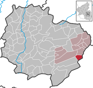
| Location of the Lautersheim community in the Donnersbergkreis | ||
  |
||

Lautersheim is a municipality in the Donnersbergkreis in Rhineland-Palatinate . It belongs to the Göllheim community .
geography
location
The community is located between Kaiserslautern and Worms on a hill of the Göllheim hill country belonging to the Alzeyer hill country; the south of the district forms the northern slope of the Eisenberg basin . The Bad Dürkheim district connects to the south and east . Neighboring communities are - clockwise - Biedesheim , Quirnheim , Ebertsheim , Kerzenheim and Göllheim .
Elevations and waters
The 302.1 meter high Galgenberg , alternatively called Göllheimer Höhe , extends at the boundary of Göllheim and Biedesheim . The Esper , which measures 309 m , rises at the municipality boundary to Kerzenheim .
At the southern edge of the settlement area, the Mangelbach rises , which flows to the southeast and flows into the Rodenbach within Ebertsheim .
history
The first mention of the place is currently unclear. Early documentary mentions of a place liutmarsheim or liutresheim in donations to the Lorsch monastery could refer to both Lautersheim and Laumersheim , which is only 10 km away . In the middle of the 13th century, the place belonged to the Höningen monastery . At the end of the 15th century, the Rosenthal Abbey also owned property in Lautersheim.
The place gave its name to a noble family, of which several knights are documented as bearers of the name from the year 1238. When the noble family died out, the place fell into the possession of the County of Leiningen-Westerburg , to which it belonged until the end of the 18th century. The place was occupied by the French in 1793.
From 1798 to 1814, when the Palatinate was part of the French Republic (until 1804) and then part of the Napoleonic Empire , Lautersheim was incorporated into the canton of Göllheim and was subordinate to the Mairie Kertzenheim . In 1815 the place had a total of 299 inhabitants. In the same year it was added to Austria . Just one year later, the place, like the entire Palatinate, changed to the Kingdom of Bavaria . From 1818 to 1862 Lautersheim belonged to the Land Commissioner Kirchheim - later Kirchhheimbolanden ; from this the district office of Kirchhheimbolanden emerged.
From 1939 the place was part of the Kirchheimbolanden district . After the Second World War , Ramsen became part of the then newly formed state of Rhineland-Palatinate within the French occupation zone . In the course of the first administrative reform in Rhineland-Palatinate , Lautersheim moved to the newly formed Donnersbergkreis in 1969 ; three years later, the community was incorporated into the Göllheim Association, which was also newly formed .
religion
The Protestant parish in Lautersheim is looked after by the pastor in Kerzenheim. The Catholic Church was a branch of St. Oswald in Boßweiler until 2007 , but was then changed to Göllheim.
politics
Municipal council
The municipal council in Lautersheim consists of twelve council members, who were elected by a majority vote in the local elections on May 26, 2019 , and the honorary local mayor as chairman.
The distribution of seats in the municipal council:
| choice | SPD | CDU | FWG | WGR | total |
|---|---|---|---|---|---|
| 2019 | by majority vote | 12 seats | |||
| 2014 | - | - | 3 | 9 | 12 seats |
| 2009 | 3 | 4th | 4th | 1 | 12 seats |
| 2004 | 3 | - | 7th | 2 | 12 seats |
- FWG = Free Voter Group Lautersheim e. V.
mayor
The local mayor is Thomas Mattern. In the local elections on May 26, 2019, he was confirmed in his office with 88.57% of the votes.
Community partnerships
There is a partnership with the Thuringian community of Abtsbessingen .
Culture
Cultural monuments
Are located on site a total of 13 properties under conservation are, including the two local churches. The Protestant church in Lautersheim is a sandstone block building from 1837. The Catholic community uses the Church of St. Joseph, a wooden emergency church from 1912.
nature
The 16 fruit trees on the L 448 are a natural monument in the municipality .
Events
The biggest festival in the village is the “Lautersheimer Kerwe”, which has been celebrated on the fourth weekend in September without interruption since 1968. The highlight here is the “Kerwe Parade” followed by a “ Kerweredd ” on Sunday afternoon.
Sports
The football club SV Lautersheim has been playing in the lowest German division since it was founded in 1953, which is now referred to as the "district class". In 2001 the SV Lautersheim had its greatest sporting success in its history: In addition to the championship in the district league, the district cup victory and the vice district championship were also achieved.
Economy and Infrastructure
economy
The earthenware factory Grünstadt got its clay partly from the area of the municipality Lautersheim
traffic
State road 448 runs through the village . Within the development, the district road 71 branches off to Göllheim. The A 63 in the west, the A 6 in the south and the A 61 in the east are just a short distance away . The next train station is Ebertsheim on the Eistalbahn Grünstadt - Ramsen .

Personalities
Sons and daughters of the church
- Philipp Leonhard Mann (1819–1876), member of the Bavarian state parliament
- Johann Adam Mann (1821–1886), member of the Bavarian state parliament, grave in the local cemetery
People who worked on site
- Ludwig von Gemmingen-Hornberg (1901–1978), nobleman and politician, lived in the community from 1964 until his death
Web links
- Literature about Lautersheim in the Rhineland-Palatinate State Bibliography
Individual evidence
- ↑ State Statistical Office of Rhineland-Palatinate - population status 2019, districts, communities, association communities ( help on this ).
- ↑ Thomas Bauer: The medieval districts . In: Geschichtlicher Atlas der Rheinlande, Habelt, Bonn 2000, ISBN 3-7927-1818-9
- ↑ Ernst Christmann: The settlement names of the Palatinate. Publishing house of the Palatinate Society for the Advancement of Science, Speyer 1952, p. 348.
- ↑ Re-parish of the Lautersheim branch from the parish of Boßweiler St. Oswald to the parish of Göllheim St. Johannes Nepomuk - OVB 8/2006
- ^ The Regional Returning Officer Rhineland-Palatinate: Municipal Council Election 2019 Lautersheim. Accessed August 31, 2019 .
- ^ The Regional Returning Officer Rhineland-Palatinate: Municipal elections 2014, city and municipal council elections.
- ↑ The Regional Returning Officer Rhineland-Palatinate: direct elections 2019. Accessed on August 31, 2019 (see Göllheim, Verbandsgemeinde, eighth line of results).
- ^ Mann, Philipp Leonhard in the parliamentary database at the House of Bavarian History
- ^ Mann, Johann Adam in the parliamentary database at the House of Bavarian History

Albisheim (Pfrimm) | Alsenz | Bayerfeld-Steckweiler | Bennhausen | Biedesheim | Bischheim | Bistiffer | Bolanden | Börrstadt | Breunigweiler | Bubenheim | Dannenfels | Dielkirchen | Dried mussel | Dreisen | Solitude | Eisenberg (Palatinate) | Falkenstein | Finkenbach-Gersweiler | Gauersheim | Gaugrehweiler | Gehrweiler | Gerbach | Göllheim | Gonbach | Gundersweiler | Höringen | Ilbesheim | Immesheim | Imsbach | Imsweiler | Jakobsweiler | Lime kiln | Katzenbach | Candle Home | Kirchheimbolanden | War field | Lautersheim | Pay field | Mannweiler-Cölln | Marnheim | Morschheim | Mörsfeld | Münchweiler an der Alsenz | Münsterappel | Niederhausen an der Appel | Niedermoschel | Oberhausen an der Appel | Upper Muschel | Oberndorf | Oberwiesen | Orbis | Ottersheim | Ramsen | Ransweiler | Rathskirchen | Reichsthal | Rittersheim | Rockenhausen | Ruppertsecken | Rüssingen | Saint Alban | Schiersfeld | Schönborn | Schweisweiler | Souls | Sippersfeld | Sitters | Stahlberg | Standenbühl | Steinbach am Donnersberg | Stetten | Teschenmoschel | Unkenbach | Waldgrehweiler | Wartenberg-Rohrbach | Weitersweiler | Winnweiler | Winterborn | Würzweiler | Zellertal