
Ottersheim
| coat of arms | Germany map | |
|---|---|---|

|
Coordinates: 49 ° 38 ' N , 8 ° 6' E |
|
| Basic data | ||
| State : | Rhineland-Palatinate | |
| County : | Donnersbergkreis | |
| Association municipality : | Goellheim | |
| Height : | 233 m above sea level NHN | |
| Area : | 2.74 km 2 | |
| Residents: | 370 (Dec. 31, 2019) | |
| Population density : | 135 inhabitants per km 2 | |
| Postal code : | 67308 | |
| Area code : | 06355 | |
| License plate : | KIB, ROK | |
| Community key : | 07 3 33 058 | |
| Association administration address: | Freiherr-vom-Stein-Strasse 1–3 67307 Göllheim |
|
| Website : | ||
| Local Mayor : | Rüdiger Kragl | |
| Location of the local community Ottersheim in the Donnersbergkreis | ||
  |
||

Ottersheim is a municipality in the Donnersbergkreis in Rhineland-Palatinate . It belongs to the Göllheim community .
geography
The municipality of Ottersheim is located north of the Palatinate Forest Nature Park , between Kaiserslautern and Worms , on the south-eastern foothills of the Zollstock. The Ammelbach flows through it. Neighboring communities (clockwise) are Immesheim , Bubenheim , Biedesheim and Rüssingen .
history
There was already a settlement in Roman times, as demonstrated by sarcophagi found at the end of the 19th century. Documentary mentions can be found for the first time in the Lorsch Codex for the year 772. In the Middle Ages Ottersheim belonged to different lords until it finally became part of the Electoral Palatinate in 1481 . In this regard, it is closely related to the neighboring Immesheim .
After 1792 the region was occupied by French troops in the First Revolutionary War and annexed after the Peace of Campo Formio (1797) . From 1798 to 1814 Ottersheim belonged to the French department of Donnersberg and was assigned to the canton of Göllheim . Due to the agreements reached at the Congress of Vienna (1815) and an exchange contract with Austria , the region became part of the Kingdom of Bavaria in 1816 . From 1818 the municipality of Ottersheim was assigned to the Kirchheim district commissioner in the Bavarian Rhine District, later to the Kirchheimbolanden district office, from which the Kirchheimbolanden district emerged in 1938 . There were two settlement centers, Ober- and Unter-Ottersheim, which only gradually grew together after 1850.
After the Second World War , Ottersheim became part of the then newly formed state of Rhineland-Palatinate within the French occupation zone and was part of the Palatinate administrative district until 1968 . Since 1969 the community has belonged to the Donnersbergkreis and since 1972 to the Göllheim association.
- Population development
The development of the population of Ottersheim, the values from 1871 to 1987 are based on censuses:
|
|

politics
Municipal council
The council in Ottersheim consists of eight council members, who in the local elections on May 26, 2019 in a proportional representation were elected, and the honorary mayor as chairman.
The distribution of seats in the municipal council:
| choice | WGO | WGK | total |
|---|---|---|---|
| 2019 | 5 | 3 | 8 seats |
| 2014 | by majority vote | 8 seats | |
| 2009 | by majority vote | 8 seats | |
- WGO = voter group Ottersheim e. V.
- WGK = voter group Kragl
mayor
The local mayor is Rüdiger Kragl. In the runoff election on June 16, 2019, he prevailed with a share of 53.69% of the vote, succeeding Alois Demmerle, who had not run for office after 15 years.
Culture and sights
Like its neighboring communities, Ottersheim is a street village ; but with the peculiarity that it developed on two arms of a street crossing. The heart of the community is the Catholic Church “St. Amandus ” (popularly also called“ Dom (or Cathedral) vom Violental ”), which is intended for four parishes. It also has a font that is over 500 years old .
In Ottersheim every year on the feast of Corpus Christi, the procession through the village is held with four altars that are lovingly decorated by the residents. Believers from near and far come to this festival.
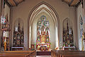
St. Amandus Choir

St. Amandus organ loft

St. Amandus baptismal font (around 1500)


See also:
Economy and Infrastructure
The B 47 runs north of Ottersheim . The closest motorway is the A 63 ( Mainz - Kaiserslautern ).
Personalities
Sons and daughters of the place
- Johann Philipp Janson (1707–1758), Catholic priest in the Archdiocese of Mainz , builder of the baroque church of St. John the Baptist in Mönchberg , Lower Franconia
People who worked on site
- Ernst von Gagern (1807–1865), scion of a well-known German noble family and an important priest figure of the 19th century in the diocese of Speyer, was pastor of Ottersheim from 1839 to 1845.
literature
- M. Hoffmann: The Göllheim Association - A cultural and historical travel guide. Göllheim 1997.
Web links
- Ortgemeinde Ottersheim on the website of the Verbandsgemeinde Göllheim
- Literature about Ottersheim in the Rhineland-Palatinate State Bibliography
Individual evidence
- ↑ State Statistical Office of Rhineland-Palatinate - population status 2019, districts, communities, association communities ( help on this ).
- ↑ State Statistical Office Rhineland-Palatinate: Regional data.
- ^ The State Returning Officer Rhineland-Palatinate: Local elections, individual results
- ^ The regional returning officer RLP: Municipal council election 2014 Ottersheim. Accessed August 31, 2019 .
- ↑ The Regional Returning Officer RLP: direct elections 2019. see Göllheim, Verbandsgemeinde, ninth line of results. Accessed August 31, 2019 .
- ^ The Rhine Palatinate: Ottersheim: management team almost completely replaced. August 18, 2019, accessed August 31, 2019 .
- ^ Eduard Schmitt: Mönchberger Kirchengeschichte , Mönchberg 2001, Caruna Druck, Kleinheubach, p. 23

Albisheim (Pfrimm) | Alsenz | Bayerfeld-Steckweiler | Bennhausen | Biedesheim | Bischheim | Bistiffer | Bolanden | Börrstadt | Breunigweiler | Bubenheim | Dannenfels | Dielkirchen | Dried mussel | Dreisen | Solitude | Eisenberg (Palatinate) | Falkenstein | Finkenbach-Gersweiler | Gauersheim | Gaugrehweiler | Gehrweiler | Gerbach | Göllheim | Gonbach | Gundersweiler | Höringen | Ilbesheim | Immesheim | Imsbach | Imsweiler | Jakobsweiler | Lime kiln | Katzenbach | Candle Home | Kirchheimbolanden | War field | Lautersheim | Pay field | Mannweiler-Cölln | Marnheim | Morschheim | Mörsfeld | Münchweiler an der Alsenz | Münsterappel | Niederhausen an der Appel | Niedermoschel | Oberhausen an der Appel | Upper Muschel | Oberndorf | Oberwiesen | Orbis | Ottersheim | Ramsen | Ransweiler | Rathskirchen | Reichsthal | Rittersheim | Rockenhausen | Ruppertsecken | Rüssingen | Saint Alban | Schiersfeld | Schönborn | Schweisweiler | Souls | Sippersfeld | Sitters | Stahlberg | Standenbühl | Steinbach am Donnersberg | Stetten | Teschenmoschel | Unkenbach | Waldgrehweiler | Wartenberg-Rohrbach | Weitersweiler | Winnweiler | Winterborn | Würzweiler | Zellertal