Breunigweiler
| coat of arms | Germany map | |
|---|---|---|

|
Coordinates: 49 ° 34 ' N , 7 ° 58' E |
|
| Basic data | ||
| State : | Rhineland-Palatinate | |
| County : | Donnersbergkreis | |
| Association municipality : | Winnweiler | |
| Height : | 247 m above sea level NHN | |
| Area : | 3.24 km 2 | |
| Residents: | 450 (Dec. 31, 2019) | |
| Population density : | 139 inhabitants per km 2 | |
| Postal code : | 67725 | |
| Area code : | 06357 | |
| License plate : | KIB, ROK | |
| Community key : | 07 3 33 011 | |
| LOCODE : | DE FM | |
| Association administration address: | Jakobstrasse 29 67722 Winnweiler |
|
| Website : | ||
| Local Mayor : | Marcel form | |
| Location of the local community Breunigweiler in the Donnersbergkreis | ||
Breunigweiler is a municipality in the Donnersbergkreis in Rhineland-Palatinate . It belongs to the Winnweiler community , within which it is the third smallest local community in terms of population.
geography
location
Breunigweiler is located in the North Palatinate Bergland on one of the last northern foothills of the Palatinate Forest in the very south-east of the Winnweiler community . Neighboring communities are - clockwise - Börrstadt , Dreisen , Göllheim , Kerzenheim and Sippersfeld
Elevations and waters
The Pfrimm flows through the village . Within the municipality, it accepts several tributaries such as the Bruchbach and the Sippersfelder Bach . The 345 meter high Petzenberg rises in the south of the district .
history
Breunigweiler probably originated between AD 600 and 750. The first documentary mention dates from the year 1130, when the Archbishop of Mainz Adalbert I donated goods to the cathedral chapter in Breunigweiler. In 985 Briuningeswilare - as it was then called - was a victim of the Salian church robbery .
Until the end of the 18th century, Breunigweiler belonged to the Stauf rule, which was last owned by the Princes of Nassau-Weilburg .
After 1792 French revolutionary troops occupied the region and annexed it after the Peace of Campo Formio (1797) . From 1798 to 1814, when the Palatinate was part of the French Republic (until 1804) and then part of the Napoleonic Empire , the village belonged to the French department of Donnersberg and was assigned to the canton of Winnweiler . In 1802 the community had 301 inhabitants: 14 Catholics, 251 Lutherans, 13 Reformed, and 23 Jews.
Due to the agreements reached at the Congress of Vienna (1815) and an exchange contract with Austria , the region became part of the Kingdom of Bavaria in 1816 . From 1818 to 1862 Breunigweiler belonged to the Land Commissioner Kaiserslautern ; from this the district office of Kaiserslautern emerged. On December 1, 1900, the community moved to the newly created district office Rockenhausen .
In 1928 Breunigweiler had 283 residents who lived in 65 residential buildings. From 1939 the place was part of the district of Rockenhausen . After the Second World War , Breunigweiler was part of the French occupation zone and in 1946 became part of the newly formed state of Rhineland-Palatinate . In the course of the first Rhineland-Palatinate administrative reform , the place changed to the newly created Donnersbergkreis ; three years later, the community was incorporated into the also newly created community of Winnweiler .
religion
The former church of St. Margaretha was a branch of Börrstadt in 1501 and had the Otterberg abbot as patron saint in 1516 . In 1928, 269 residents were Protestant and 14 were Catholic. On the Protestant side, Breunigweiler forms a church with Sippersfeld and Neuhemsbach with its seat in Sippersfeld, on the Catholic side with Börrstadt.
politics
Municipal council
The municipal council in Breunigweiler consists of eight council members who were elected in the local elections on May 26, 2019 , and the honorary local mayor as chairman.
mayor
- Marcel Form (since 2019)
- Marc-Oliver Gerke (2009-2019)
- Jürgen Blickensdörfer (2004–2009)
- Helmut Burgdörfer (1989-2004)
- Ludwig Müller (1972-1989)
Until 1972, Breunigweiler formed a mayor's office together with Sippersfeld and did not have its own mayor.
coat of arms
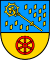
| Blazon : “Divided by blue and gold; above in a field sprinkled with golden shingles a golden crook with a cloverleaf curvature, below a six-spoke red wheel. " | |
Culture
Buildings
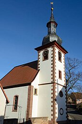
The Jewish cemetery is designated as a monument zone; With the war memorial and the Protestant church, there are also two individual objects that are under monument protection . The Protestant church in the village was built between 1763 and 1766 and was last renovated in 2008.
societies
The culture and sports club Breunigweiler e. V.
Economy and Infrastructure
economy
In the past, the community was mainly characterized by agriculture. After the Second World War, a new building area was built. Meanwhile, Breunigweiler is mainly a residential community. There are several small businesses in the village.
traffic
The state road 394 and the district road 44 run through Breunigweiler .
The closest train station was Börrstadt from 1873 on the Langmeil – Monsheim Zellertal Railway, which was completed in the same year . In 1983 passenger traffic was discontinued, so that Langmeil (Pfalz) train station became the next operating point. During the seasonal reactivation in 2001, the Börrstadt train station did not come back into operation. Since 1999 Münchweiler (Alsenz) has been the closest train stop to the Alsenz Valley Railway from Breunigweiler.
Personalities
- Barbara Göler von Ravensburg (before 1505–1535), abbess of the Cistercian convent Rosenthal (Palatinate), ensured that Breunigweiler became the property of the latter
literature
- Literature about Breunigweiler in the Rhineland-Palatinate state bibliography
Web links
Individual evidence
- ↑ State Statistical Office of Rhineland-Palatinate - population status 2019, districts, communities, association communities ( help on this ).
- ↑ Irmtraud Liebeherr: The possession of the Mainz cathedral chapter in the late Middle Ages , Mainz: Self-published by the Society for Middle Rhine Church History, 1971, p. 217 ( dilibri.de )
- ↑ a b c Michael Frey : Attempt at a geographical-historical-statistical description of the ko. bayer. Rheinkreises , third part, Speier: Neidhard, 1837, p. 142 ff ( Google Books )
- ↑ daten.digitale-sammlungen.de: List of localities for the Free State of Bavaria . Retrieved August 28, 2018 .
- ^ The Regional Returning Officer RLP: City Council Election 2019 Breunigweiler. Retrieved September 2, 2019 .
- ^ The Regional Returning Officer RLP: direct elections 2019. see Winnweiler, Verbandsgemeinde, second line of results. Retrieved September 2, 2019 .


