
Schönborn (Palatinate)
| coat of arms | Germany map | |
|---|---|---|
_COA.svg)
|
Coordinates: 49 ° 39 ' N , 7 ° 46' E |
|
| Basic data | ||
| State : | Rhineland-Palatinate | |
| County : | Donnersbergkreis | |
| Association municipality : | North Palatinate Country | |
| Height : | 417 m above sea level NHN | |
| Area : | 2.6 km 2 | |
| Residents: | 124 (Dec. 31, 2019) | |
| Population density : | 48 inhabitants per km 2 | |
| Postal code : | 67808 | |
| Area code : | 06361 | |
| License plate : | KIB, ROK | |
| Community key : | 07 3 33 068 | |
| Association administration address: | Bezirksamtsstrasse 7 67806 Rockenhausen |
|
| Website : | ||
| Local Mayor : | Dirk Braun | |
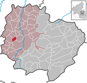
| Location of the local community Schönborn in the Donnersbergkreis | ||
  |
||

Schönborn in the northern Pfalz is a municipality in the Donnersbergkreis in Rheinland-Pfalz . It belongs to the Nordpfälzer Land association.
geography
The place is located in the North Palatinate Uplands west of the Donnersberg between Kaiserslautern and Bad Kreuznach .
history
Until the end of the 18th century, Schönborn belonged to the Reipoltskirchen rulership , which was directly owned by the empire and was ultimately jointly owned by the Princes of Isenburg-Büdingen and the Counts of Hillesheim .
After 1792 the region was occupied by French troops in the First Revolutionary War and annexed after the Peace of Campo Formio (1797) . From 1798 to 1814 Schönborn belonged to the French department of Donnersberg and was assigned to the canton of Rockenhausen . Due to the agreements reached at the Congress of Vienna (1815) and an exchange contract with Austria , the region became part of the Kingdom of Bavaria in 1816 . From 1818 the community of Schönborn was assigned to the Kirchheim regional commissioner in the Bavarian Rhine District, later to the Kirchheimbolanden district office, from which the Kirchheimbolanden district emerged in 1938 .
After the Second World War , Schönborn became part of the then newly formed state of Rhineland-Palatinate within the French occupation zone and belonged to the administrative district of Palatinate until 1968 . Since 1969 the community belongs to the Donnersbergkreis .
- Population development
The development of the population of Schönborn, the values from 1871 to 1987 are based on censuses:
|
|
politics
Municipal council
The municipal council in Schönborn consists of six council members, who were elected by a majority vote in the local elections on May 26, 2019 , and the honorary local mayor as chairman.
mayor
Local mayor is Dirk Braun. He was elected by the local council on June 11, 2019. This ended a seven-month vacancy that had existed since November 2018 because the previous mayor Beate Kitzka had resigned from her position for health reasons.
coat of arms
|
|
Blazon : “Under a silver shield head split by silver and green; In the head of the shield two red bars accompanied by red stones (4: 3: 2), on the right a lily-crowned red fountain, on the left a fallen silver anchor. " |
traffic
The public transport in the transport association Rhein-Neckar integrated (VRN). Lines 913 and 915 of the Rhein-Nahe bus service connect the community on weekdays with the nearest small towns, Rockenhausen and Obermoschel , as well as with the Rockenhausen and Alsenz stations on the Alsenz Valley Railway . In the evenings and on weekends there is a taxi from the Donnersberg Transport Association .
The place is about 5 kilometers from the federal highway 48 Bad Bergzabern - Bingen am Rhein . The B 48 also provides the connection to the about 15 kilometers away junction Winnweiler of Highway 63 ago.
On the outskirts, in a former radar station, there has been a Theravada Buddhist temple for several years .
See also
literature
- Literature about Schönborn in the Rhineland-Palatinate state bibliography
Web links
Individual evidence
- ↑ a b State Statistical Office of Rhineland-Palatinate - population status 2019, districts, municipalities, association communities ( help on this ).
- ↑ Michael Frey : Attempt at a geographical-historical-statistical description of the royal Bavarian Rhine district , Volume 1, Speyer 1837, S, 379 ( Google Books )
- ↑ State Statistical Office Rhineland-Palatinate - regional data
- ^ The Regional Returning Officer RLP: City Council Election 2019 Schönborn. Retrieved August 24, 2019 .
- ^ The Rheinpfalz: Schönborn: Dirk Braun is the new local mayor. June 12, 2019, accessed August 25, 2019 .

Albisheim (Pfrimm) | Alsenz | Bayerfeld-Steckweiler | Bennhausen | Biedesheim | Bischheim | Bistiffer | Bolanden | Börrstadt | Breunigweiler | Bubenheim | Dannenfels | Dielkirchen | Dried mussel | Dreisen | Solitude | Eisenberg (Palatinate) | Falkenstein | Finkenbach-Gersweiler | Gauersheim | Gaugrehweiler | Gehrweiler | Gerbach | Göllheim | Gonbach | Gundersweiler | Höringen | Ilbesheim | Immesheim | Imsbach | Imsweiler | Jakobsweiler | Lime kiln | Katzenbach | Candle Home | Kirchheimbolanden | War field | Lautersheim | Pay field | Mannweiler-Cölln | Marnheim | Morschheim | Mörsfeld | Münchweiler an der Alsenz | Münsterappel | Niederhausen an der Appel | Niedermoschel | Oberhausen an der Appel | Upper Muschel | Oberndorf | Oberwiesen | Orbis | Ottersheim | Ramsen | Ransweiler | Rathskirchen | Reichsthal | Rittersheim | Rockenhausen | Ruppertsecken | Rüssingen | Saint Alban | Schiersfeld | Schönborn | Schweisweiler | Souls | Sippersfeld | Sitters | Stahlberg | Standenbühl | Steinbach am Donnersberg | Stetten | Teschenmoschel | Unkenbach | Waldgrehweiler | Wartenberg-Rohrbach | Weitersweiler | Winnweiler | Winterborn | Würzweiler | Zellertal