Appelbach
| Appelbach | ||
|
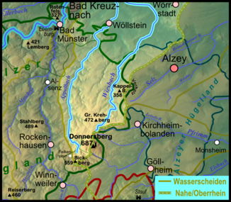
Map of the catchment area (without estuary) of the two parallel Donnersberg brooks Appelbach (left) and Wiesbach (right) |
||
| Data | ||
| Water code | DE : 25494 | |
| location | Germany | |
| River system | Rhine | |
| Drain over | Nahe → Rhine → North Sea | |
| Headwaters | north of Falkenstein 49 ° 36 ′ 57 ″ N , 7 ° 52 ′ 53 ″ E |
|
| Source height | approx. 395 m above sea level NHN | |
| muzzle | near Bretzenheim in the Nahe Coordinates: 49 ° 52 ′ 27 ″ N , 7 ° 54 ′ 2 ″ E 49 ° 52 ′ 27 ″ N , 7 ° 54 ′ 2 ″ E |
|
| Mouth height | approx. 98 m above sea level NHN | |
| Height difference | approx. 297 m | |
| Bottom slope | approx. 7.5 ‰ | |
| length | 39.6 km (over the Königsbach: 41.8 km) |
|
| Catchment area | 174.615 km² | |
| Discharge at the Planig A Eo gauge: 170.2 km². Location: 1.6 km above the mouth |
NNQ (06/28/1964) MNQ 1955/2017 MQ 1955/2017 Mq 1955/2017 MHQ 1955/2017 HHQ (12/21/1993) |
9 l / s 104 l / s 553 l / s 3.2 l / (s km²) 7 m³ / s 21 m³ / s |
The Appelbach , also called the Appel , is a 39.6 kilometer long right tributary of the Nahe in Rhineland-Palatinate , Germany .
geography
course
The river rises in the North Palatinate Bergland southwest of the Donnersberg , about one kilometer northeast of Falkenstein on the western flank of the Kübelberg at an altitude of 395 m above sea level. NHN . From here it flows primarily in northern directions. After flowing through the villages of Würzweiler , Gerbach , Sankt Alban , Gaugrehweiler and Oberhausen an der Appel , the Appelbach reaches the Rheinhessische Schweiz . In the now narrow valley are Münsterappel , Niederhausen an der Appel , Tiefenthal and Neu-Bamberg .
Between Neu-Bamberg and Wöllstein , the Palatinate Uplands merge into the Rheinhessen hill country . The Dunzelbach , the most important tributary of the Appelbach, flows below Wöllstein . In the lower reaches Badenheim , Pfaffen-Schwabenheim and Planig are still flowed through before the Appelbach opposite Bretzenheim at 98 m above sea level. NHN flows into the Nahe from the right .
On its 39.6 km long path, the Appelbach overcomes a height difference of 297 m, which corresponds to an average bed gradient of 7.5 ‰. It drains its 174.615 km² catchment area via Nahe and Rhine into the North Sea and is therefore part of the Rhine river system.
Tributaries
The most important tributary is the Dunzelbach with a catchment area of 30.3 km². Further tributaries with a catchment area of more than 10 km² are Gerbach , Gutenbach and Ellerbach .
In the following, the tributaries of the Appelbach are named in the order from the source to the mouth, which are managed by the Rhineland-Palatinate water management authority. In each case, the orographic position of the mouth, the length, the size of the catchment area, the altitude of the mouth and the river code are given. To make the last one easier to read, a separator (-) was inserted behind the prefix that is common to all of the Appelbach's tributaries.
| Surname |
location |
Length [km] |
Catchment area [km²] |
Mouth height [m above sea level NHN] |
DGKZ |
|---|---|---|---|---|---|
| Mordkammertalbach | right | 3.8 | 8.875 | 322 | 25494-12 |
| Tiefenbach | right | 1.3 | 1,313 | 273 | 25494-14 |
| Gerbach | right | 4.2 | 11,154 | 252 | 25494-2 |
| Stößbach | right | 1.7 | 1.383 | 242 | 25494-312 |
| Alder Trench | Left | 1.0 | 1,932 | 241 | 25494-32 |
| Dörrnbach | right | 1.0 | 0.951 | 234 | 25494-34 |
| Gutenbach | right | 6.3 | 10.124 | 209 | 25494-4 |
| Grundbach | right | 3.3 | 4,773 | 197 | 25494-52 |
| Nonnbach | right | 1.2 | 1.518 | 191 | 25494-54 |
| Feilerbach | Left | 2.4 | 2.992 | 191 | 25494-56 |
| Fürfelderbach | Left | 2.1 | 6,598 | 166 | 25494-58 |
| Ellerbach | Left | 6.5 | 10,330 | 149 | 25494-6 |
| Dunzelbach | right | 7.7 | 30.365 | 125 | 25494-8 |
| Karlebach | Left | 6.0 | 8,771 | 116 | 25494-92 |
| Hackenheimerbach | Left | 3.6 | 5.646 | 107 | 25494-94 |
Individual evidence
- ↑ a b c d Topographic map 1: 25,000
- ↑ a b c d e GeoExplorer of the Rhineland-Palatinate Water Management Authority ( information )
- ↑ Measurement data: Planig level / waters: Appelbach
