Wiesbach (Nahe)
| Wiesbach | ||
|
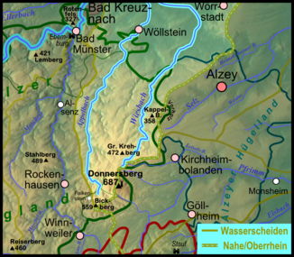
Map of the catchment area (without estuary) of the two parallel Donnersberg brooks Wiesbach (right) and Appelbach (left) |
||
| Data | ||
| Water code | DE : 25498 | |
| location | Germany | |
| River system | Rhine | |
| Drain over | Nahe → Rhine → North Sea | |
| source | in the North Palatinate Uplands 49 ° 38 ′ 54 ″ N , 7 ° 55 ′ 26 ″ E |
|
| Source height | approx. 445 m above sea level NHN | |
| muzzle | near Grolsheim Coordinates: 49 ° 54 '13 " N , 7 ° 54' 47" E 49 ° 54 '13 " N , 7 ° 54' 47" E |
|
| Mouth height | approx. 92 m above sea level NHN | |
| Height difference | approx. 353 m | |
| Bottom slope | approx. 8 ‰ | |
| length | 44.4 km | |
| Catchment area | 201.534 km² | |
| Discharge at the Gensingen A Eo gauge : 197 km² Location: 2.5 km above the mouth |
NNQ (07/03/1976) MNQ 1956/2017 MQ 1956/2017 Mq 1956/2017 MHQ 1956/2017 HHQ (05/26/1978) |
11 l / s 112 l / s 446 l / s 2.3 l / (s km²) 5.35 m³ / s 18 m³ / s |
|
The Wiesbach near Welgesheim in winter |
||
The Wiesbach is a 44.4 kilometer long brook that rises in the North Palatinate Bergland ( Rhineland-Palatinate ) and flows into the Nahe near Grolsheim in the Mainz-Bingen district (also Rhineland-Palatinate) . The second order water body is maintained by the Wiesbachverband, to which the districts of Alzey-Worms and Mainz-Bingen belong. Along with the Selz and the Appelbach, it is one of the most important rivers in Rheinhessen .
Geography and geology
The Wiesbach , a tributary of the Nahe, drains together with the Appelbach the north- west area of Rheinhessen. Its headwaters are located in the North Palatinate Bergland, the northern foothills of the Donnersberg massif , which is rich in precipitation , west of Haide, a district of Kirchheimbolanden . In the first third of its course, the streambed is cut into igneous rock and sediments from the Rotliegend period (285 - 255 million years). This is accompanied by relatively tight talks .
From Nieder-Wiesen to Flonheim, for example, it flows through the charming landscape of Rheinhessen Switzerland . Here, with the exception of the floodplain, mixed forests predominate on the poor soils. Oberwiesen calls itself a "forest community". For a long time, the mining of mercury and the mining of building stones (especially Flonheim sandstone ) were important in this region . Today magmatites of the Donnersberg are extracted in huge quarries in the headwaters of the brook (Winkelbach) and processed into gravel material. The further course of the Wiesbach through the tertiary deposits of the Rheinhessen hill country shows a wide valley with gently sloping slopes. This landscape with its fertile loess soils is characterized by viticulture and agriculture . After approx. 48 km the Wiesbach reaches the Nahe near Gensingen .
course
The Wiesbach arises near the Rothenkircherhof (above Oberwiesen ) from the Winkelbach and the brooks around a former poultry farm. It flows into a branch of the Nahe near Gensingen near the Rumpf-Mühle . This flows back into the main river shortly before Grolsheim. The stream flows through Oberwiesen, Nieder-Wiesen and Wendelsheim , where it passes the Teufelsrutsch and unites with the Finkenbach . In the further course the water flows through Uffhofen , Flonheim , Armsheim , Schimsheim and Wallertheim , at the eastern edge of which the Sulzheimer Bach flows. The Wiesbach then passes the Wißberg near Gau-Bickelheim , where it takes the Johannsbach ( coming from the Wißberg towards Sankt Johann ). Now it turns to the northwest, first flowing through Sprendlingen , then past Welgesheim , Zotzenheim and Gensingen . The stream is accompanied by the Armsheim-Wendelsheim ( Wiesbachtalbahn ) railway between Wendelsheim and Armsheim and the Worms-Bingen ( Rheinhessenbahn ) railway between Armsheim and Gensingen-Horrweiler .
Tributaries
- Steindellerbach ( left )
- Schanzengraben ( right )
- Goßenbach ( left )
- Ambach ( right ), 2.5 km
- (Bach aus den Molkenwiesen ) ( right ), 2.6 km
- Kernbach ( left ), 3.9 km
- Wörlebach ( left ), 1.9 km
- (Stream past Nebelborn ) ( left ), 1.5 km
- (Stream along the Spitzenberg ) ( left ), 1.2 km
- Oberwiesenbach ( left ), 4.6 km
- Schnifteberger Bach ( left )
- Teufelswiesenbach (past Teufelsborn ) ( right ), 2.7 km
- Dembach ( right ), 2.1 km
- Dornbach ( right ), 1.6 km
- Grubenbach ( left )
- Nackbach ( right ), 2.3 km
- Finkenbach ( left ), 7.4 km
- Moosbach ( right ), 3.2 km
- Aulheimer Graben ( right ), 1.8 km
- Bornheimer Bach ( right ), 1.6 km
- Mörschgraben (Mörschgraben) ( right ), 5.0 km
- Bernhardsgraben ( right )
- Wallertheimer Graben ( right )
- Sulzheimer Bach ( right ), 4.5 km
- Gau-Weinheimerbach ( right ), 2.2 km
- Johannsbach ( right ), 5.9 km
- Höllengraben ( right ), 1.9 km
- (Bach von der Sonnhöll ) ( right ), 1.5 km
- Horrweiler Graben ( right ), 4.7 km
Individual evidence
- ↑ a b Topographic map 1: 25,000
- ↑ a b GeoExplorer of the Rhineland-Palatinate Water Management Authority ( information )
- ↑ Measurement data: Gensingen gauge / body of water: Wiesbach

