
Palatinate Way of St. James
| Palatinate Way of St. James | |
|---|---|
 Destination of all the Way of St. James: Cathedral of Santiago de Compostela |
|
| Data | |
| length | 125 km (north route), 125 or 112 km (south route) |
| location | Pfalz ( Rhineland-Palatinate ), northern route about 5 km in the Saarpfalz district ( Saarland ), monastery route through northern Palatinate to Saarland |
| Markers |
|
| Starting point |
Speyer (north and south route), Worms (monastery route) 49 ° 19 ′ 2 ″ N , 8 ° 26 ′ 33 ″ E |
| Target point |
Hornbach and Blieskastel 49 ° 11 ′ 12.9 ″ N , 7 ° 22 ′ 10.6 ″ E |
| Type | Long-distance hiking trail |
| Level of difficulty | light |
| season | all year round |
The Palatinate Way of St. James are the Palatinate sections of the European Way of St. James , which lead as historical pilgrimage routes to the pilgrimage city of Santiago de Compostela in northwestern Spain . According to Christian tradition, the apostle James the Elder ( Spanish: Santiago ) is said to be buried there.
Overview
Several routes within the Palatinate are now known. Two, the north route and the south route , begin on the Rhine at the Imperial Cathedral in Speyer and end in the small town of Hornbach ( district of Südwestpfalz ), where the grave of St. Pirminius is located in the former monastery . To the south of it, the pilgrimage route, which is united from here, crosses the border to France . Both Palatinate routes were marked by the Palatinate Forest Association , a connection to the further French pilgrimage routes has been made. In the Palatinate Forest , old hiking trails were often identified as parts of the Way of St. James.
Upstream sections from areas to the north and east led to Speyer. The route is well documented from the north, which from the southern border of Rheinhessen should actually also be included in the Palatinate Way of St. James. It connected the two other imperial cathedrals in Mainz and Worms - via intermediate stations in Oppenheim and Frankenthal - with Speyer. In the south of Frankenthal, the Pilgerpfad district , which emerged after the Second World War , bears its name, the footpath of the same name that crosses the district in the center is marked with a scallop shell.
From 2007 to 2011 a monastery route was sought and described, which leads from the Worms Cathedral ( Lage ) through the Palatinate to Metz . This route connects to the north route at Landstuhl, but does not follow it to Hornbach. In Blieskastel, it joins the route that comes from Hornbach via Saarbrücken to Lorraine .
Routes
North route
course
The originally known route is the north route, which is almost 147 kilometers long. It runs from Speyer, partly along the Speyerbach , in a westerly direction through the Upper Palatinate Rhine plain . At Neustadt an der Weinstrasse , the route enters the Palatinate Forest through the Haardt mountain range . In this the Jakobsweg leads, now through the Elmsteiner valley and generally up the Speyerbach, up to the area of its source at Johanniskreuz . There, at the interface between the Lower and Middle Franconian Pastures , it crosses the watershed between the Rhine and Moselle at an altitude of 470 m . Then the Way of St. James leaves the Palatinate Forest down through the Karlstal of the Moosalb to the Gelterswoog . Over the northern edge of the Sickinger Höhe it leads past Landstuhl, only at Vogelbach does it descend into the valley of the Landstuhler Bruch to the former pilgrimage church . From there the path then leads south-west and later south over the Zweibrücker Westrich . Coming from the Schlossberg , the city of Homburg is touched in Kirrberg . In the town of Zweibrücken, the route crosses the Schwarzbach and meets the flood plain from its left tributary, the Hornbach . It follows this up and finally reaches the pilgrimage site of the same name from the north.
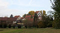
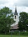
Stations

Town hall of Dudenhofen

Former Marientraut Castle in Hanhofen
Protestant Church in Speyerdorf

Lambrecht in the 19th century

Barbara Chapel under the spell
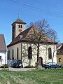
Catholic Church from Hauptstuhl

Bruchmühlbach -Miesau

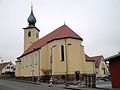
Former hospital church in Vogelbach

Signpost near Bechhofen


.jpg)


South route
course
A southern route was later also identified. This branch runs through the southern Palatinate Forest, the German part of the Wasgau . The path leads from Speyer to the south, up the Rhine, to the mouth of the Klingbach in a former loop of the Rhine, which has been called Michelsbach since the Rhine was straightened . The route follows the Klingbach through the southern Palatinate Rhine plain westwards.
The subsequent curve to the north via Landau , whose stations are marked with *, means a considerable detour (26 instead of 13 kilometers); it is not authentic, but was added for tourist reasons. For a previous hiker, it made sense to continue from Herxheim along the Klingbach and take the direct route to the Palatinate Forest near Klingenmünster and thus save yourself three hours of extra march.
Then - first in the valley of the Erlenbach and then along today's French border - the Wasgau is crossed in a north-westerly direction and Hornbach is reached from the east, from the chopping knife side. The total distance of the longer variant via Landau is 125 kilometers, the more plausible direct connection up the Klingbach is only 112 kilometers long.
Stations
St. Pankratius Church in Berghausen , today the municipality of Römerberg
St. Laurentius Church in Mechtersheim , today the municipality of Römerberg

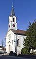
St. John's Church in Sondernheim
Heard with St. George's Church

Dieterskirchel near Rülzheim

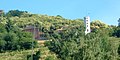
Neolithic excavations in Herxheim
Catholic Church of St. Joseph in Offenbach *

Collegiate Church in Landau *

Chapel on the Kleine Kalmit near Arzheim *
Slevogthof near Leinsweiler *

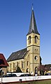
Catholic Church St. Gallus in Birkenhördt

Church in Bundenthal

Frescoes in the Christ Church in Rumbach


Monastery route
course
The name Klosterroute refers to the large number of (former) monasteries that are touched along the way.
The path begins at Worms Cathedral and heads west to the former pilgrimage site of Zell . We continue to Göllheim , where the path branches and runs for about 20 kilometers in two roughly parallel branches. The north leads to the former Münsterdreisen monastery near Dreisen (Münsterhof), the Otterberg abbey church is the next destination. From here it goes directly to Landstuhl or via Kaiserslautern. This is also where the southern branch leads, from Göllheim past the ruins of the Rosenthalerhof monastery to the monastery church in Enkenbach . In Landstuhl , both routes merge with the northern route of the Palatinate Way of St. James and lead past the pilgrim church in Vogelbach to Homburg . While the northern route now moves directly towards Hornbach, the monastery route leaves the Palatinate and joins the Saarland route in Blieskastel , which leads from Hornbach via Saarbrücken to Metz .
literature
- Susanne Rieß-Stumm (Red.): Palatine Way of St. James. On historical paths from Speyer to Hornbach Monastery . Hiking guide. Ed .: Diocese archives Speyer. Kuntz Verlag, Gleiszellen-Gleishorbach 2010, ISBN 978-3-933507-03-7 .
- Brigitte Lüger-Ludewig: Rendez-vous on the Way of St. James . Novel. Kuntz Verlag, Gleiszellen-Gleishorbach 2005, ISBN 3-933507-06-5 (new ISBN 978-3-933507-06-8 ).
- Worms – Metz monastery route . Hiking & pilgrimage guides Palatinate St. James' Way. Kuntz Verlag, Gleiszellen-Gleishorbach 2011, ISBN 978-3-933507-14-3 .
Web links
- Kuntz Published by Pfälzer Jakobswege
- North route, with hiking compass in six stages from Speyer via Neustadt - Elmstein - Landstuhl - Homburg to Hornbach
Individual evidence
- ↑ Dieter Mauer: On the trail of the pilgrim path . In: Frankenthaler . The city magazine. No. 7 , November 2010, p. 4 f .
- ↑ Monastery route Worms – Metz, Kuntz, Gleiszellen-Gleishorbach 2011
- ^ Paul Burgard, Ludwig Linsenmayer (ed.): Jakobswege on Saar, Blies and Mosel . Hiking guide for the region. Association for the Promotion of the State Archives, Saarbrücken 2006