
Klingenmünster
| coat of arms | Germany map | |
|---|---|---|

|
Coordinates: 49 ° 8 ' N , 8 ° 1' E |
|
| Basic data | ||
| State : | Rhineland-Palatinate | |
| County : | Southern Wine Route | |
| Association municipality : | Bad Bergzabern | |
| Height : | 168 m above sea level NHN | |
| Area : | 10.72 km 2 | |
| Residents: | 2281 (Dec. 31, 2019) | |
| Population density : | 213 inhabitants per km 2 | |
| Postal code : | 76889 | |
| Area code : | 06349 | |
| License plate : | SOUTH | |
| Community key : | 07 3 37 049 | |
| Association administration address: | Königstrasse 61 76887 Bad Bergzabern |
|
| Website : | ||
| Mayoress : | Kathrin Flory ( SPD ) | |
| Location of the local community of Klingenmünster in the southern Weinstrasse district | ||
  |
||

Klingenmünster is a municipality in the Südliche Weinstrasse district in Rhineland-Palatinate . It belongs to the Verbandsgemeinde Bad Bergzabern , within which it is the second largest local community in terms of population and the furthest north. Klingenmünster is a state-approved resort . The community gained national recognition as the location of the Palatinate Clinic for Psychiatry and Neurology .
geography
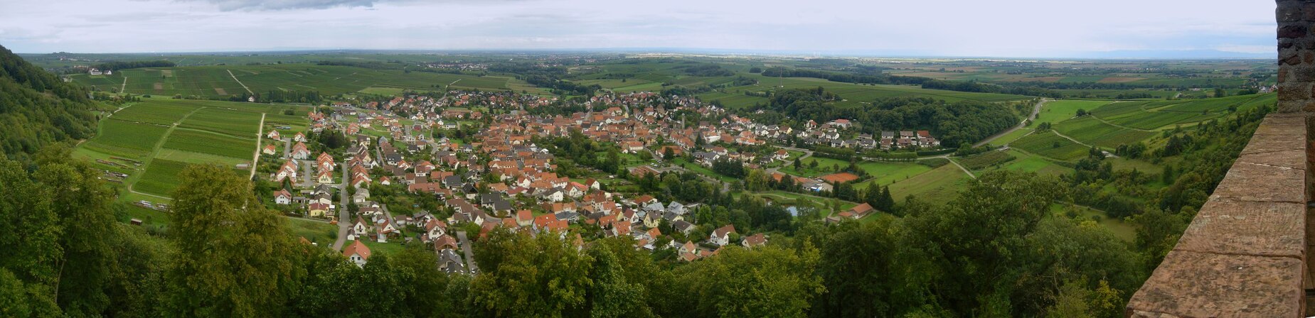
location
The wine village is in the Weinstrasse region on the Haardtrand, about five kilometers north of Bad Bergzabern and forms the northern end of the Bad Bergzabern community. The west of the district protrudes into the Wasgau , as the southern part of the Palatinate Forest and the adjoining northern part of the Vosges are also called. Klingenmünster also includes the Frauenlob (Wagmühle), Kaiserbacher Mühle (Talmühle), Klingbachhof, Magdalenenhof and Sägemühle residential areas . To the north of the main town is the Palatinate Clinic for Psychiatry and Neurology . Neighboring communities are - clockwise - Waldhambach , Eschbach , Göcklingen , Heuchelheim-Klingen , Gleiszellen-Gleishorbach , Silz and Münchweiler am Klingbach .
Surveys
The 503.7 m high Treutelsberg rises northwest of the settlement area . The Abtskopf ( 487 m ) is located at the boundary of Silz and Gleiszellen-Gleishorbach . The 395 m high Hatzelberg extends further to the east . To the south of the settlement area stands the 229 m high Kreuzberg and to the east of this the 201 m high Kühnberg .
Waters
The Klingbach flows through the community in a west-east direction . The Martha spring is located in the north-west of the district in the middle of the Palatinate Forest . In the north, the Kaiserbach runs for a short distance over the district of Klingenmünster.
Klingenmünster 2008

history


The place Klingenmünster emerged as a settlement of farmers and craftsmen around the imperial monastery Klingenmünster . The history of the community is therefore very closely linked to the monastery in economic and political terms. The farmers and craftsmen of Klingenmünster were serfs of the monastery and belonged to the Fronhof stock.
When Adalbert I became Archbishop of Mainz in the 12th century , his relatives, the Counts of Saarbrücken, came to the area around Klingenmünster. They drew political power to themselves and took over the feudal rule that had previously exercised the monastery. This meant a significant weakening of the monastery. In a document from 1411, the "poor serfs and henchmen" of Klingenmünster were mentioned for the first time. This refers to the entirety of the inhabitants of the village. The period from 1618 to 1714 was marked by warlike events such as the Thirty Years War , the Wars of Succession, Peasants ' Wars and the Wars of Conquest of Louis XIV . In 1743, the 55th Infantry Regiment in Klingenmünster temporarily owned a garrison.
In autumn 1792 the French Revolution took hold of the place and Klingenmünster was one of the first communities to join this movement. There were no nationalist currents at work here, only social motives. This was followed by an upheaval in property relations and the social order. The aristocracy, clergymen and officials lost their privileged position, citizens and peasants gained more importance. From the end of the 18th century, the municipality was part of the French Republic , then part of the Napoleonic Empire until 1815 , and incorporated into the canton of Bergzabern in the department of the Lower Rhine . In 1815 it was added to Austria . Just one year later, on May 1, 1816, like the entire Palatinate, it moved to the Kingdom of Bavaria . From 1818 to 1862, Klingen-Münster belonged - as it was spelled at the time - to the Land Commissioner Bergzabern ; The Bergzabern district office emerged from this .
In 1939 the community was incorporated into the Bergzabern district. After the Second World War , the municipality within the French occupation zone became part of the then newly formed state of Rhineland-Palatinate and the administrative district of Palatinate . During the first Rhineland-Palatinate administrative reform changed the place on 7 June 1969 in the newly created district Landau-Bad Bergzabern, in 1978 in South County Wine Trail is renamed . In 1972 the community was assigned to the also newly formed Bad Bergzabern community . The hamlets of Frauenlob and Kaiserbacher Mühle, which originally belonged to Waldhambach, were also moved to Klingenmünster.
population
religion
Christianity

In the Middle Ages the community was the place of activity of the Iroschottische Church .
The monastery and later canon monastery of Klingenmünster was dissolved in 1565. The Palatinate then became Protestant and the collegiate church was used as a Protestant church. Reformed pastors have been recorded in Klingenmünster since 1566 . As a result of the Counter-Reformation , Catholics came to the place again from 1684. At the beginning of the 18th century, the simultaneous churches were dissolved. In 1762 a reformed church was built, the building of which now functions as a Protestant kindergarten, and in 1782 a Lutheran church, which now houses the Protestant rectory. In 1818 an evangelical church reform took place in the Palatinate. A Protestant union of Lutherans and Reformed people emerged. In 1829 the Lutheran church was demolished and only the larger Reformed church was used. This did not have a church tower, but only a roof turret. In 1848 a 30 meter high tower was built in front of the church and the roof turret was removed. The royal Bavarian building authority in Munich had warned against this because the subsoil was not stable. In 1937 the bell cage was renewed and a third bell was installed. In the last days of the Second World War, an anti-tank barrier was built near the church and the foundations of the church and the tower were opened. The church became dilapidated and had to be demolished in 1956. In 1958 the new Protestant church was consecrated at its current location.
On October 31, 2014, 38.5 percent of the population were Protestant and 38.6 percent Catholic. The rest belonged to another religion or were non-denominational.
Judaism
There was once a synagogue on site . The members of the Jewish community once belonged to the district rabbinate Landau (Palatinate) and were buried in Annweiler . Along the Wine Road also remember two stumbling blocks in addition to Jews who were deported during the Third Reich.
Population development
The development of the population of Klingenmünster, the values from 1871 to 1987 are based on censuses:
|
|
politics
Municipal council
The local council in Klingenmünster consists of 16 council members, who were elected in a personalized proportional representation in the local elections on May 26, 2019 , and the honorary local mayor as chairman.
The distribution of seats in the municipal council:
| choice | SPD | CDU | FWG | total |
|---|---|---|---|---|
| 2019 | 8th | 4th | 4th | 16 seats |
| 2014 | 6th | 4th | 6th | 16 seats |
| 2009 | 6th | 5 | 5 | 16 seats |
| 2004 | 7th | 5 | 4th | 16 seats |
mayor
- −2009: Wilfried Türck ( SPD )
- 2009–2019: Erwin Grimm (FWG)
- since 2019: Kathrin Flory (SPD)
coat of arms
|
|
Blazon : "In gold, a black mark in the form of a bar rising from a horizontal line and dividing at the top with curved ends, covered with a red scale, above a floating red paw cross." |
|
Founding of the coat of arms: In 1483, the mayor of Klingenmünster, Hans Johels, used his own seal, which contained his private coat of arms and which shows a figure similar to the current district sign in the local coat of arms.
Since 1736 there was a court seal from Klingenmünster, the sign of which was apparently based on the old coat of arms. There was thus a long unchanged tradition of the seal from 1483 to 1736. In 1963 the cross was added as an attribute of the patron saint of the St. Michael monastery and the official approval for the local coat of arms was granted by the Mainz Ministry of the Interior . |
Culture
Buildings
- Cultural monuments

The Palatinate Clinic for Psychiatry and Neurology , the area of the former Abbey District of Klingenmünster as well as the Fliehburg Heidenschuh , the Salierburg Waldschlössel and the Stauferburg Landeck , all of which are within the boundaries of Klingenmünster, are designated as monument zones.
There are also numerous individual monuments, including the Martinsturm on the Treutelsberg , the Villa Dr. , built between 1928 and 1929 and designed by the architect Richard Riemerschmid . Schaffer as well as the Stiftsschaffnei , which contains built-in Romanesque remains.
- Other structures
The Palatinate memorial for the victims of Nazi psychiatry is also located in the cemetery of the Pfalzklinikum .
nature
With a pine tree west of the settlement area and a sparrowhawk tree near the Kaiserbacher Mühle, there are a total of two natural monuments on site . The Haardtrand - Am Klingbach nature reserve is partially within the boundaries of Klingenmünster.
Events
On August 28, 2016, Klingenmünster was the opening location of the German Wine Route Adventure Day ; the motto was "Heavenly Palatinate".
Economy and Infrastructure
economy

The community has always been very rural and conservative. There was fear of a break in the traditional order, loss of rule in the village and the abandonment of valuable usable areas through industrialization. In 1857 a clinic for the “mentally ill” opened under state management, which valued the rural cultural landscape for therapeutic reasons. Foreign companies had a difficult time and had no long-term success. In 1857 there was a cigar factory, a paper mill, a few grinding mills and a sawmill; A steam laundry was added in 1870. At the end of the 19th century, a beer brewery, a furniture factory and various red sandstone quarries were opened. However, these companies did not have a longer lifespan, only a brick factory was able to hold up into the 1960s. There was also a temporary radio station in the community .
In the meantime, the residents of the community make a living from their work in the Pfalzklinikum , from viticulture and tourism. The former has been operating the Peilsender (for young people), a radio station for young people , since 2015 . In addition, the clinic for child and adolescent psychiatry, psychosomatics and psychotherapy is closely connected to the Pfalzklinikum. Klingenmünster is a wine-growing town and as such part of the Palatinate wine-growing region . The Maria Magdalena single vineyard is located on site .
traffic
The monastery was built at the intersection of two Roman military roads that ran in an east-west direction. In the neighboring village of Gleiszellen a Roman manor is occupied, in Klingenmünster itself there are only a few finds, so that settlement by the Romans can already be ruled out. The military roads can be proven in a changed location until the Middle Ages. In the 13th century, the descendants of the Counts of Saarbrücken set up two new centers of power: Bergzabern and Landau. The old elevated roads to the west lost their meaning. Instead, a shorter connection was established from Landau via Barbelroth to Weißenburg , which led past Klingenmünster. The road from Bergzabern via Klingenmünster and Annweiler to Zweibrücken was expanded in 1780 due to the Chausseeordnung of the Electoral Palatinate . However, it did not bring any revitalization to the region.

In 1793 the road to Heuchelheim was expanded and the previously closed wall around the Klingenmünster monastery was broken open. In the 19th century a road was built from Landau via Ingenheim to Bergzabern and Weißenburg. In 1860 the “Neue Straße” was built to the north, which connects to the road to Annweiler-Landau and continues south to Bergzabern.
On December 1, 1892, the Klingbachtalbahn with its terminus in Klingenmünster was opened. Passenger traffic came to a standstill as early as 1957, freight traffic followed in 1968. Since then, the closest train stations have been Rohrbach on the Neustadt – Wissembourg railway line and Bad Bergzabern on the line beginning in Winden . Klingenmünster is now connected to the local transport network via bus lines 524 ( Albersweiler –Pfalzklinikum), 531 (Landau – Annweiler) and 540 (Landau – Bad Bergzabern).
The federal road 48 , which is identical in this area to the German Wine Road , runs through the village . The state road 493 leads in the western direction to Vorderweidenthal and in the eastern direction to Hördt . At the Pfalzklinikum, the state road 508 branches off the federal road and runs to Frankweiler . The federal motorway 65 runs around ten kilometers to the east .
tourism

The German Wine Route cycle path from Schweigen-Rechtenbach to Bockenheim an der Weinstrasse and the Klingbach cycle path from Vorderweidenthal to Hördt lead through Klingenmünster .
The community is also located on the southern route of the Palatinate Way of St. James , on the Palatinate Almond Trail and on the Palatinate Weinsteig ; Moreover, runs through them one by Bad Münster until after Saint Germanshof leading trail that with a white-blue bar is marked and one of red yellow with a bar is selected, the connection to the Wellbachtal and after Ruelzheim manufactures . There is also the Three Castles hike and hiking trails marked with a green triangle on a white background and a white triangle .
In the middle of the Palatinate Forest on the boundary to Gleiszellen-Gleishorbach is also the Karlsplatzhütte operated by the local branch of the Palatinate Forest Association .
Personalities
Sons and daughters of the church

- Stephan Zipff (1761–1813), doctor, professor of medicine at the University of Heidelberg
- August Becker (1828–1891), German writer and folklorist from the Palatinate .
- George Michael Hahn (1830–1886), 1864–1865 Governor of the US state Louisiana .
- Joseph Alois Bach (1838–1912), papal Zouave
- Johannes Klein (1845–1917) engineer and designer, founded the company Klein, Schanzlin & Becker in 1871 together with the brewery director Schanzlin and the farmer Becker .
- Jakob Mathèus (1862–1946), administrative lawyer and politician
- Jakob Klein (1869–1945), engineer, took over his brother's company "Klein, Schanzlin & Becker" independently in 1905.
- Julius Hahn (1871 – after 1936), administrative lawyer
- Albert Decker (1883–1967), lawyer, President of the Senate at the Bavarian Administrative Court and historian
- Oskar Bischoff (1912–1985), Palatinate dialect poet
- Lilo Beil (* 1947), author
- Hermann Bohrer (* 1956/57), politician (SPD), since 1999 mayor of the Bad Bergzabern community
People who worked on site
- Friedrich Wilhelm Rebenack (1791–1866), Bavarian civil servant and member of the state parliament, died in the local mental hospital
- Friedrich Carl Bentz (1799–1864), businessman and politician, died on site on a business trip.
- Hermann Hofmann (1880–1941), politician (ZENTRUM) and teacher, worked as a teacher in Klingenmünster for a time
- Gerhart Mall (1909–1983), psychiatrist, neurologist and psychologist, was medical advisor and director of the Pfalzklinik from 1952 to 1971 and then ran a local private clinic
- Theo Fehn (1910–1984), pastor, was temporarily parish administrator in Klingenmünster
- Otfried K. Linde (1932–2019), pharmacist and author, was the pharmacy director of the Pfalzklinik.
- Heidrun Möller (* 1945), politician (SPD), attended primary school on site
- Johannes Cramer (* 1950), architect, prepared an appraisal for the local parish center in 1995
- Norbert Schäfer , holder of the Order of Merit of the State of Rhineland-Palatinate since 2004 , lives on site
Web links
- Website of the local community of Klingenmünster
- Literature about Klingenmünster in the Rhineland-Palatinate state bibliography
Individual evidence
- ↑ a b State Statistical Office of Rhineland-Palatinate - population status 2019, districts, municipalities, association communities ( help on this ).
- ↑ a b State Statistical Office Rhineland-Palatinate - regional data
- ↑ State Statistical Office Rhineland-Palatinate (ed.): Official directory of the municipalities and parts of the municipality. Status: January 2019 [ Version 2020 is available. ] . S. 160 (PDF; 3 MB).
- ↑ Erich Hehr: Agricultural geographical studies in the Klingenmünster / Südpfalz district 1964
- ↑ Municipal statistics . In: KommWis. October 31, 2014, accessed November 30, 2014 .
- ↑ https://www.wahlen.rlp.de/de/kw/wahlen/kg/verbindungen/3370204900.html
- ^ The Regional Returning Officer Rhineland-Palatinate: Municipal elections 2014, city and municipal council elections
- ↑ https://klingenmuenster.de/Bürgermeisterin%2C%20Beigegendee%20und%20Ratsträger%20vereidigt
- ^ Karl Heinz Debus: The great book of arms of the Palatinate . Neustadt an der Weinstrasse 1988, ISBN 3-9801574-2-3
- ↑ Dr. von Jan, Archivrat: Expert opinion on the local coat of arms of Klingenmünster prepared for the approval process from 1963.

Cities: Annweiler am Trifels | Bad Bergzabern | Edenkoben
Municipalities: Albersweiler | Altdorf (Palatinate) | Barbelroth | Cheapheim-Ingenheim | Birkenhördt | Birkweiler | Böbingen (Palatinate) | Böchingen | Böllenborn | Bornheim (Palatinate) | Burrweiler | Dernbach (Palatinate) | Dierbach | Dörrenbach | Edesheim | Eschbach (Palatinate) | Essingen (Palatinate) | Eusserthal | Flemlingen | Frankweiler | Freimersheim (Palatinate) | Gleisweiler | Gleiszellen-Gleishorbach | Goecklingen | Gommersheim | Gossersweiler-Stein | Großfischlingen | Hainfeld (Palatinate) | Hergersweiler | Herxheim near Landau / Pfalz | Herxheimweyher | Heuchelheim Blades | Hochstadt (Palatinate) | Ilbesheim near Landau in the Palatinate | Vaccinees | Insheim | Kapellen-Drusweiler | Kapsweyer | Kirrweiler (Palatinate) | Small fish | Klingenmünster | Knöringen | Leinsweiler | May Chamber | Münchweiler am Klingbach | Niederhorbach | Niederotterbach | Oberhausen (near Bad Bergzabern) | Oberotterbach | Oberschlettenbach | Offenbach an der Queich | Pleisweiler-Oberhofen | Ramberg (Palatinate) | Ranschbach | Rhodt under Rietburg | Rinnthal | Rohrbach (Palatinate) | Roschbach | Saint Martin (Palatinate) | Schweigen-Rechtenbach | Schweighofen | Siebeldingen | Silz | Steinfeld (Palatinate) | Venningen | Völkersweiler | Vorderweidenthal | Waldhambach | Waldrohrbach | Walsheim | Wernersberg | Weyher in the Palatinate