Frankweiler
| coat of arms | Germany map | |
|---|---|---|

|
Coordinates: 49 ° 14 ' N , 8 ° 3' E |
|
| Basic data | ||
| State : | Rhineland-Palatinate | |
| County : | Southern Wine Route | |
| Association municipality : | Landau country | |
| Height : | 243 m above sea level NHN | |
| Area : | 6.86 km 2 | |
| Residents: | 846 (Dec. 31, 2019) | |
| Population density : | 123 inhabitants per km 2 | |
| Postal code : | 76833 | |
| Area code : | 06345 | |
| License plate : | SOUTH | |
| Community key : | 07 3 37 026 | |
| LOCODE : | DE HFC | |
| Association administration address: | To 44 No. 31 76829 Landau in the Palatinate |
|
| Website : | ||
| Local Mayor : | Bernd Nerding | |
| Location of the local community Frankweiler in the district of Südliche Weinstrasse | ||
Frankweiler is a municipality in the Südliche Weinstrasse district in Rhineland-Palatinate . It belongs to the Landau-Land association, which has its administrative headquarters in the city of Landau in the Palatinate . Frankweiler has the lowest property tax rates in Rhineland-Palatinate and is debt free.
geography
location
The wine village is in the Weinstrasse region ; there, the Rhine Plain and Haardt , as the eastern edge of the Palatinate Forest is called, meet. Neighboring communities are - clockwise - Gleisweiler , Böchingen , Landau in der Pfalz , Siebeldingen , Albersweiler , Dernbach (Pfalz) and an exclave belonging to Böchingen. In the Middle Palatinate Forest there is also the Frankweiler Forest, an exclave of the community that borders on those of Landau in the Palatinate, Siebeldingen and Albersweiler.
Elevations and waters
The southern slope including the summit of the 581.2 meter high Orensberg belongs to Frankweiler. The 450-meter-high Ringelsberg extends further south-east near the settlement area . The Sandbach rises in the west of the district and changes to that of Dernbach after around 250 meters. The Hainbach running north of the development forms the border with Gleisweiler. The Dörenbach runs along the eastern edge of the forest enclave ; to the west of it is the 554 meter high Hahnenkopf .
history
The etymology of the place name suggests early settlement layers of the 5th to 8th centuries. As a Franconian land grab , the colonization took place through the establishment of localities (mainly in the Rhine-Main-Danube region).
Frankweiler was first mentioned in a document in 1249, as the inhabitants of the village paid wine to the Eusserthal monastery at that time . In 1330 the village came from the rule Scharfeneck to the Palatinate , in 1410 by division of inheritance to the Palatinate outlying state Pfalz-Zweibrücken (from 1693 Oberamt Bergzabern), and in 1768 again to the Electoral Palatinate , within which the Oberamt Germersheim was subordinate.
In the course of the coalition wars , the part of the Palatinate on the left bank of the Rhine was separated from the part on the right bank of the Rhine due to the occupation. From 1798 to 1814 the areas on the left bank of the Rhine were part of the French Republic (until 1804) and then part of the Napoleonic Empire . During this time, Franckweiler was - as it was spelled at the time - part of the Département du Mont-Tonnerre (Donnersberg department), the canton of Edenkoben and was subordinate to the Mairie Gleisweiler . In 1815 the community had a total of 742 inhabitants. With the Congress of Vienna in the same year, the heartland of the Palatinate on the left bank of the Rhine was first given to Austria and in 1816 to the Kingdom of Bavaria on the basis of an exchange agreement . A year later the community moved to the canton of Landau . From 1818 to 1862 Leinsweiler belonged to the Landau Landau commissioner ; from this the district office of Landau emerged.
From December 1918 to June 1930 the Rhine Palatinate was occupied by French troops . From 1939 the place was part of the Landau district in the Palatinate . After the Second World War , the municipality within the French occupation zone became part of the then newly formed state of Rhineland-Palatinate and belonged to the administrative district of Palatinate until 1968 . In 1968 it was incorporated into the administrative district of Rheinhessen-Pfalz . During the first Rhineland-Palatinate administrative reform moved Frankweiler in the newly created on June 7, 1969 the district Landau-Bad Bergzabern, in 1978 in South County Wine Trail is renamed . In 1972 the community was assigned to the newly formed Landau-Land association.
politics
Municipal council
The municipal council in Frankweiler consists of twelve council members, who were elected by a majority vote in the local elections on May 26, 2019 , and the honorary local mayor as chairman. Until 2014, a personalized proportional representation was used; for the 2019 election a new, joint group of voters was formed.
The distribution of seats in the municipal council:
| choice | SPD | CDU | FDP | FWG | EFWG | total |
|---|---|---|---|---|---|---|
| 2019 | by majority vote | 12 seats | ||||
| 2014 | 2 | 2 | 1 | 4th | 3 | 12 seats |
| 2009 | 3 | - | 1 | 6th | 2 | 12 seats |
| 2004 | 2 | - | 1 | 7th | 2 | 12 seats |
mayor
Bernd Nerding became the local mayor of Frankweiler in 2014. In the direct election on May 26, 2019, he was confirmed in his office for another five years with a share of the vote of 85.10%.
coat of arms
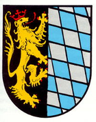
| Blazon : "In a split shield on the right in black a left-turned, red-armored, tongued and crowned golden lion, on the left with silver and blue roughened." | |
Parish partnership
The partnership with the city of Cullman (Alabama) , USA, has existed since 1987. This city was founded by an emigrant from Frankweiler in Alabama. His parents' house has since been demolished and converted into a village square with a fountain and memorial plaque.
Culture
The town center and the cemetery are designated as monument zones; there are also a total of 32 individual monuments . The Ringelsberghütte and the ruins of Alt-Scharfeneck Castle are also located within the municipality .
Infrastructure
economy
Frankweiler is a wine-growing village and as such part of the Palatinate wine-growing region . The Biengarten and Kalkgrube single layers are located on site . The light yellow, local sandstone was previously extracted in a quarry.
traffic
Frankweiler is on the German Wine Route . The place is connected to the local transport network via bus line 521 .
Personalities
Sons and daughters of the church
- Friedrich Eckerle (1849–1924), politician
- Ludwig Bach (1865–1912), university professor in Marburg
- Fritz Eckerle (1877–1925), writer
- John Gottfried Cullmann (1823–1895), founder of the city of Cullman, Alabama, USA
People who worked in the place
- Dieter Eifler (* 1949), materials scientist, lives in Frankweiler.
Web links
- Official website of the Frankweiler community
- Literature about Frankweiler in the Rhineland-Palatinate state bibliography
Individual evidence
- ↑ State Statistical Office of Rhineland-Palatinate - population status 2019, districts, communities, association communities ( help on this ).
- ^ The Rhine Palatinate of July 20, 2006
- ↑ Caroline Lambert: Frankweiler: Again majority election for local council. Die Rheinpfalz, April 27, 2019, accessed on April 10, 2020 .
- ^ The Regional Returning Officer Rhineland-Palatinate: Local elections 2019, city and municipal council elections.
- ↑ Caroline Lambert: Frankweiler: Bernd Nerding wants to remain local chief. Die Rheinpfalz, April 12, 2019, accessed on April 10, 2020 .
- ^ The State Returning Officer Rhineland-Palatinate: direct elections 2019. Retrieved on April 10, 2020 (see Landau-Land, Verbandsgemeinde, sixth row of results).
- ↑ General Directorate for Cultural Heritage Rhineland-Palatinate (ed.): Informational directory of cultural monuments - Southern Wine Route district. Mainz 2020, p. 36 ff. (PDF; 10 MB).
- ^ History of Cullman, Alabama. Accessed November 10, 2019 .


