Ringelsberg (Palatinate)
| Ringelsberg | ||
|---|---|---|
|
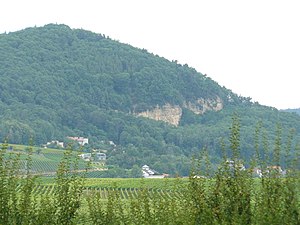
Ringelsberg with an old quarry |
||
| height | 450 m | |
| location | Rhineland-Palatinate , Germany | |
| Mountains | Palatinate Forest | |
| Coordinates | 49 ° 13 '52 " N , 8 ° 2' 43" E | |
|
|
||
|
Ringelsberghütte |
||
The Ringelsberg is 450 m above sea level. NHN high mountain of the Palatinate Forest . It is located near Frankweiler in the Rhineland-Palatinate district of Südliche Weinstrasse . The Alt-Scharfeneck castle ruins and the Ringelsberghütte of the Palatinate Forest Association are located on the mountain . From the hut's panorama terrace you have a wonderful view of the Rhine valley, with good visibility as far as the Odenwald and Black Forest. There are some well-marked hiking trails around the Ringelsberg. An educational forest trail with information about the UNESCO Biosphere Reserve Palatinate Forest is interesting. Various other huts in the area can be reached in one to two hours.
The former Frankweiler quarry is striking and can be seen from afar. The yellow sandstone, rather untypical for the region, is the eastern foundation wall of the Ringelsberg. Large parts of the rock on which Alt-Scharfeneck Castle (Frankenburg) stood were used for the construction of the fortress in Germersheim .
Individual evidence
- ↑ LANIS: Topographic map - height and position of the Ringelsberg. Retrieved August 26, 2020 .
- ^ Pfalz Touristik eV: Ringelsberghütte on the Ringelsberg, 455 m. In: outdooractive.com. Retrieved August 1, 2020 .
- ^ Palatinate sights. Retrieved July 1, 2020 .
- ^ Fried Blaul: Bad Gleisweiler, the upper Haardt Mountains and the Palatinate Switzerland . AH Gottschick's bookstore (E. Witter), Neustadt an der Haardt 1857.


