Pleisweiler-Oberhofen
| coat of arms | Germany map | |
|---|---|---|

|
Coordinates: 49 ° 7 ' N , 8 ° 0' E |
|
| Basic data | ||
| State : | Rhineland-Palatinate | |
| County : | Southern Wine Route | |
| Association municipality : | Bad Bergzabern | |
| Height : | 190 m above sea level NHN | |
| Area : | 5.05 km 2 | |
| Residents: | 842 (Dec. 31, 2019) | |
| Population density : | 167 inhabitants per km 2 | |
| Postal code : | 76889 | |
| Area code : | 06343 | |
| License plate : | SOUTH | |
| Community key : | 07 3 37 062 | |
| LOCODE : | DE POB | |
| Community structure: | 2 districts | |
| Association administration address: | Königstrasse 61 76887 Bad Bergzabern |
|
| Website : | ||
| Local Mayor : | Roland Gruschinski ( CDU ) | |
| Location of the local community Pleisweiler-Oberhofen in the district of Südliche Weinstrasse | ||
Pleisweiler-Oberhofen is a municipality in the Südliche Weinstrasse district in Rhineland-Palatinate . It was created in 1828 by amalgamating the communities of Pleisweiler and Oberhofen . It belongs to the Bad Bergzabern community .
geography
location
The state-approved resort is located between the Palatinate Forest and the Rhine in the Weinstrasse region . the west of the district protrudes into the Wasgau , as the southern part of the Palatinate Forest and the adjoining northern part of the Vosges are also called.
Pleisweiler-Oberhofen also includes the Eichenlaub house and Wappenschmiede residential areas . Neighboring communities are - in clockwise direction - Gleiszellen-Gleishorbach , Heuchelheim-Klingen , Niederhorbach , Kapellen-Drusweiler and Bad Bergzabern .
Elevations and waters
In the southwest of the municipality mark, not far from the border with Bad Bergzabern, the 315 meter high owl head rises . The Hirtenbach flows through the community in a west-east direction
history
During the construction of the bypass road, the remains of a Roman settlement were found (brick cellar with fragments of the Terra Sigillata and Terra Nigra goods ). After the battle of Zülpich the area was settled by the Franks . Blidineswilare was probably one of the oldest settlements in the region. Oberhofen was first mentioned in the 9th century as the estate of the Klingenmünster monastery . In 1828 the villages of Pleisweiler and Oberhofen were combined into one municipality under the Kingdom of Bavaria .
The newly formed community belonged to the Land Commissioner Bergzabern ; The Bergzabern district office emerged from this . In 1939 it was incorporated into the Bergzabern district. During the Second World War, the village suffered from repeated evictions and fire from artillery fire. After the war, the municipality within the French occupation zone became part of the then newly formed state of Rhineland-Palatinate. During the first Rhineland-Palatinate administrative reform moved Pleisweiler-Oberhofen in the newly created on June 7, 1969 the district Landau-Bad Bergzabern, in 1978 in South County Wine Trail is renamed . In 1972 the community was assigned to the also newly formed Bad Bergzabern community .
religion
At the end of 2013, 43.0 percent of the population were Protestant and 37.3 percent Catholic . The rest belonged to another religion or were non-denominational . The Jews who once lived in the village also owned a synagogue .
politics
Municipal council
The municipal council in Pleisweiler-Oberhofen consists of twelve council members, who were elected in the local elections on May 26, 2019 in a personalized proportional representation, and the honorary local mayor as chairman.
The distribution of seats in the municipal council:
| choice | SPD | CDU | FWG | WGG | total |
|---|---|---|---|---|---|
| 2019 | 5 | - | - | 7th | 12 seats |
| 2014 | 4th | - | - | 8th | 12 seats |
| 2009 | 5 | 4th | 3 | - | 12 seats |
| 2004 | 2 | 5 | 5 | - | 12 seats |
- WGG = Gruschinski voter group (CDU and FWG)
mayor
Roland Gruschinski (CDU) became the local mayor of Pleisweiler-Oberhofen on June 17, 2014. In the direct election on May 26, 2019, he was confirmed in his office for a further five years with a share of the vote of 52.16%. His predecessor Harald Lehmann (SPD) held the office for five years.
coat of arms
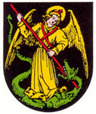
| Blazon : "In black a golden angel with golden wings, golden halo and red shoulder strap, red cross headband and red lance, killing a red-tongued green dragon lying on its back." | |
| Foundation of the coat of arms: It was approved by the Neustadt district government in 1982 and goes back to a seal from 1521. The Archangel Michael was the patron saint of the Klingenmünster monastery, to which Pleisweiler belonged. |
Culture and sights
Cultural monuments
In the district of Pleisweiler-Oberhofen there are numerous objects that are under monument protection , including the Ochsenstein Castle .
nature
The nature reserves Haardtrand - Wolfsteig and Haardtrand - Gottesacker extend over the area of the local community .
Regular events
The annual Kerwe takes place on the first weekend in September. On the second weekend in October there is an invitation to the “Fest des Federweiß” wine festival. Discussions on current political issues take place regularly under the title Pleisweiler Talks .
Economy and Infrastructure
economy
Pleisweiler-Oberhofen is a wine-growing town and as such part of the Palatinate wine-growing region . The Schloßberg single layer is located on site . In the southeast of the municipality on the border with Bad Bergzabern there is also an industrial area.
traffic
State road 508 runs through the settlement area . In the east of the municipality marker, federal road 48 runs in a north-south direction and federal road 38 for a short distance in the south-east . Pleisweiler-Oberhofen is connected to the local transport network via the 540 bus . The closest train station is in Bad Bergzabern .
tourism
The German Wine Route and the German Wine Route Cycle Route run through the community .
Sons and daughters of the church
- Heinz Leonhard (* 1958), politician (CDU)
Web links
- Internet presence of the local community Pleisweiler-Oberhofen
- In this country
- Literature about Pleisweiler-Oberhofen in the Rhineland-Palatinate state bibliography
Individual evidence
- ↑ State Statistical Office of Rhineland-Palatinate - population status 2019, districts, communities, association communities ( help on this ).
- ↑ State Statistical Office Rhineland-Palatinate - regional data.
- ↑ State Statistical Office Rhineland-Palatinate (ed.): Official directory of the municipalities and parts of the municipality. Status: January 2019 [ Version 2020 is available. ] . S. 160 (PDF; 3 MB).
- ↑ KommWis, as of December 31, 2013.
- ^ The Regional Returning Officer Rhineland-Palatinate: Local elections 2019, city and municipal council elections.
- ↑ a b c Knapp for Spiegel. Constituent municipal council meeting 2014. Die Rheinpfalz, June 21, 2014, accessed on April 22, 2020 .
- ^ The Regional Returning Officer of Rhineland-Palatinate: direct elections 2019. see Bad Bergzabern, Verbandsgemeinde, 18th line of results. Retrieved April 22, 2020 .
- ^ Karl Heinz Debus: The great book of arms of the Palatinate. Neustadt an der Weinstrasse 1988, ISBN 3-9801574-2-3 .


