Oberotterbach
| coat of arms | Germany map | |
|---|---|---|

|
Coordinates: 49 ° 4 ′ N , 7 ° 58 ′ E |
|
| Basic data | ||
| State : | Rhineland-Palatinate | |
| County : | Southern Wine Route | |
| Association municipality : | Bad Bergzabern | |
| Height : | 192 m above sea level NHN | |
| Area : | 15.37 km 2 | |
| Residents: | 1109 (Dec. 31, 2019) | |
| Population density : | 72 inhabitants per km 2 | |
| Postal code : | 76889 | |
| Area code : | 06342 | |
| License plate : | SOUTH | |
| Community key : | 07 3 37 059 | |
| LOCODE : | DE 45T | |
| Association administration address: | Königstrasse 61 76887 Bad Bergzabern |
|
| Website : | ||
| Local Mayor : | Heinz Oerther | |
| Location of the local community Oberotterbach in the southern Weinstrasse district | ||
Oberotterbach is a municipality in the Südliche Weinstrasse district in Rhineland-Palatinate . It belongs to the Bad Bergzabern community ; in terms of area, it is their second largest local community and in terms of population it is their fifth largest.
geography
location
The place lies between the Palatinate Forest and the Rhine in the Weinstrasse region . The west of the district protrudes into the Wasgau , as the southern part of the Palatinate Forest and the adjoining northern part of the Vosges are also called. This area is also part of the Upper Mundat Forest . The Brendelsmühle and Heidenbrunnenhof residential areas also belong to Oberotterbach . Neighboring communities are - clockwise - Dörrenbach , Kapellen-Drusweiler , Dierbach , Niederotterbach , Kapsweyer , Schweighofen , Schweigen-Rechtenbach , Bobenthal and Böllenborn
Surveys
The 420-meter Hohenberg extends northwest of the settlement area . Further west rise the Farrenberg ( 489.3 m ), the Kanzelberg , the Schloßberg ( 503 m ), the Querenberg , the Hohe Derst ( 561 m ) and the Zimmerhörnel .
Waters
The Otterbach flows in a west-east direction . It rises in the middle of the Wasgau in Rothenbrunnen and partially forms the boundary to Schweigen-Rechtenbach before it flows through the center of Oberotterbach. The Dierbach , a left tributary of the Otterbach, rises directly at the boundary to Dörrenbach and continues this eastward for several kilometers. In the far west, the Reisbach partially forms the border to Böllenborn and Bobenthal. The castle fountain is also located near the castle hill .
history
992 the place was in a deed of gift from King Otto III. first mentioned to the monastery Selz in Alsace.
From the end of the 18th century, the community was part of the French Republic , then part of the Napoleonic Empire until 1815 , and incorporated into the canton of Bergzabern in the department of the Lower Rhine . In 1815 it was added to Austria . Just one year later, like the entire Palatinate, it moved to the Kingdom of Bavaria . From 1818 to 1862 Ober-Otterbach - which was the spelling at the time - belonged to the Land Commissioner Bergzabern ; The Bergzabern district office emerged from this .
In 1939 the community was incorporated into the Bergzabern district. After the Second World War , the municipality within the French occupation zone became part of the then newly formed state of Rhineland-Palatinate. During the first Rhineland-Palatinate administrative reform changed the place on 7 June 1969 in the newly created district Landau-Bad Bergzabern, in 1978 in South County Wine Trail is renamed . In 1972 Oberotterbach was assigned to the also newly formed community of Bad Bergzabern .
population
Population development
The development of the population of Oberotterbach, the values from 1871 to 1987 are based on censuses:
|
|
Denomination statistics
In 2019, 43.3 percent of the population were Protestant and 24.8 percent Catholic. The remaining 31.9 percent belonged to another religion or were non-denominational. At the end of 2013, 49.5 percent of the population were Protestant and 25.7 percent Catholic. The rest belonged to another religion or were non-denominational.
politics
Municipal council
The municipal council in Oberotterbach consists of 16 council members, who were elected in a personalized proportional representation in the local elections on May 26, 2019 , and the honorary local mayor as chairman.
The distribution of seats in the municipal council:
| choice | SPD | CDU | FWG | total |
|---|---|---|---|---|
| 2019 | 4th | 4th | 8th | 16 seats |
| 2014 | 3 | 4th | 9 | 16 seats |
| 2009 | 3 | 5 | 8th | 16 seats |
| 2004 | 3 | 6th | 7th | 16 seats |
mayor
Heinz Oerther (FWG) became local mayor of Oberotterbach in 2009. In the direct election on May 26, 2019, he was confirmed in his office for another five years with a share of the vote of 74.60%. His predecessor was Fritz Beck.
coat of arms
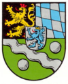
| Blazon : “Divided and split at the top, covered with a silver heart shield, inside a red armored and tongued gold crowned blue lion, top right in black a red armored, tongued and crowned golden lion, top left with silver and blue ruffled, bottom in green a silver oblique wave bar, each with a silver ball. " | |
| Reasons for the coat of arms: It was approved by the Bavarian governor in 1938 and goes back to a seal from 1558. |
Culture and sights
Buildings
- Cultural monuments
The ruins of Guttenberg Castle in the Mundatwald are designated as a monument zone . In addition, there are a total of 18 individual objects that are under monument protection .
- Other structures
The Oberotterbach Castle was once located in the middle of the settlement area .
nature
The west of the district lies in the Palatinate Forest Nature Park , which in turn is part of the Palatinate Forest-Vosges du Nord Biosphere Reserve . There are a total of two natural monuments on site .
Knight stones
There are several knight stones within the municipality . Ritterstein 11 bears the name R. Buchbacherhof and indicates a courtyard that was demolished in 1846. 12 Schanze 1704 refers to a hill from the War of the Spanish Succession . 13 Deer trough marks a depression with rainwater and 14 Three Beeches a location for three large beeches. 15 R. Schloßhütte stands on the site of a shelter that has since been lost.
Sports
Oberotterbach is mainly shaped by football. The sports club Oberotterbach 1950 e. V. provides a men's team, senior team, A-youth, D-youth and an F-youth team. Other sporting activities in Oberotterbach include table tennis, tennis, aerobics, gymnastics and model sports.
Events
On August 28, 2012, Oberotterbach was the opening location of the German Wine Route Adventure Day ; the motto was "Palatinate grape varieties".
Economy and Infrastructure
economy
Oberotterbach is a wine-growing village and as such part of the Palatinate wine-growing region ; The Sonnenberg single vineyard is located on site .
traffic
Oberotterbach is connected to the local transport network via bus line 543 (Bad Bergzabern-Wissembourg). The closest train stations are Bad Bergzabern on the Winden – Bad Bergzabern railway line and Wissembourg on the Neustadt – Wissembourg railway line .
The federal highway 38 runs through the municipality in a north-south direction . From this, the district road 25 branches off in an easterly direction to Niederotterbach.
tourism
The German Wine Route and the German Wine Route Cycle Route run through the community . It is also the starting point for Tour 10 of the Palatinate Forest Mountain Bike Park . The Derstenhäuschen is located in the middle of the forest
The Pirmasens-Belfort long-distance hiking trail marked with a yellow bar also runs through Oberotterbach . The Pfälzer Weinsteig hiking trail leading through the forest and one marked with a blue cross . Since June 2009 there has been a ten kilometer long hiking trail in the municipality in the form of the Westwall hiking trail along the bunkers, trenches and positions.
Personalities
- Stephan Lederer (1844–1923), Catholic priest, was the local pastor from 1873 to 1882
- Waltraud Hey, 1965/66 German wine queen
Web links
- Official website of the local community of Oberotterbach
- Literature about Oberotterbach in the Rhineland-Palatinate State Bibliography
Individual evidence
- ↑ State Statistical Office of Rhineland-Palatinate - population status 2019, districts, communities, association communities ( help on this ).
- ↑ State Statistical Office Rhineland-Palatinate (ed.): Official directory of the municipalities and parts of the municipality. Status: January 2019 [ Version 2020 is available. ] . S. 160 (PDF; 3 MB).
- ↑ State Statistical Office Rhineland-Palatinate: My village, my city. Retrieved September 7, 2019 .
- ↑ KommWis, as of August 31, 2019 , accessed on September 17, 2019
- ↑ KommWis, as of December 31, 2013
- ^ The Regional Returning Officer Rhineland-Palatinate: Local elections 2019, city and municipal council elections. Retrieved September 7, 2019 .
- ↑ Gerhard Sommer: On Case II: Which local chiefs in the Bad Bergzabern community are running again. Die Rheinpfalz, October 1, 2018, accessed on April 22, 2020 .
- ^ The Regional Returning Officer for Rhineland-Palatinate: direct elections 2019. see Bad Bergzabern, Verbandsgemeinde, 16th line of results. Retrieved April 22, 2020 .
- ^ Karl Heinz Debus: The great book of arms of the Palatinate. Neustadt an der Weinstrasse 1988, ISBN 3-9801574-2-3 .


