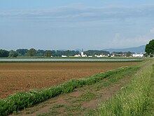
Altdorf (Palatinate)
| coat of arms | Germany map | |
|---|---|---|

|
Coordinates: 49 ° 17 ' N , 8 ° 13' E |
|
| Basic data | ||
| State : | Rhineland-Palatinate | |
| County : | Southern Wine Route | |
| Association municipality : | Edenkoben | |
| Height : | 122 m above sea level NHN | |
| Area : | 6.36 km 2 | |
| Residents: | 890 (Dec. 31, 2019) | |
| Population density : | 140 inhabitants per km 2 | |
| Postal code : | 67482 | |
| Area code : | 06327 | |
| License plate : | SOUTH | |
| Community key : | 07 3 37 002 | |
| Association administration address: | Poststrasse 23 67480 Edenkoben |
|
| Website : | ||
| Local Mayor : | Helmut Litty | |
| Location of the local community Altdorf in the district of Südliche Weinstrasse | ||
Altdorf is a municipality in the Südliche Weinstrasse district in Rhineland-Palatinate . It belongs to the community of Edenkoben .
geography
location
The village is located 7 km east of Edenkoben between the Palatinate Forest belonging Haardt and the Rhine in the middle of Gäu . Altdorf also includes the Ziegelhütte residential area , which is located in the northern municipality.
Neighboring communities are - clockwise - Neustadt an der Weinstrasse , Böbingen , Freimersheim , Großfischlingen , Venningen and Kirrweiler . In addition, two uninhabited exclaves in the Palatinate Forest, each called Altdorfer Wald , belong to the community area. The one further to the east borders clockwise - exclaves in italics - on Maikammer , Edenkoben, Rhodt unter Rietburg and Böbingen . The western border borders in a clockwise direction on Kirrweiler , Böbingen and Venningen .
Waters
The Triefenbach , which runs in a west-east direction, touches the southern edge of the development; beforehand he takes the Brühlgraben from the right . The Lachgraben flows through the south of the municipal marker . The Modenbach and its left tributary Waldgraben form the border to Großfischlingen in places and the Kropsbach in places that to Neustadt.
The eastern forest enclave is also traversed by the Triefenbach, the other is limited to the west by the Kohlbach ; inside the latter there is also the Kohlbrunnen .
history
Altdorf was mentioned for the first time in 776 in a document from Lorsch Abbey. Until the end of the 18th century, the place belonged to the Count of Degenfeld and formed a high school education office there .
From 1798 to 1814, when the Palatinate was part of the French Republic (until 1804) and then part of the Napoleonic Empire , Altdorf was incorporated into the canton of Landau . In 1815 the place had a total of 468 inhabitants. In the same year it was added to Austria . Just one year later, the place, like the entire Palatinate, changed to the Kingdom of Bavaria . At the same time, the community moved to the canton of Edenkoben . From 1818 to 1862 the community belonged to the Landau Landau commissioner ; from this the district office of Landau emerged.
From 1939 the place was part of the Landau district in the Palatinate . After the Second World War , Altdorf became part of the then newly formed state of Rhineland-Palatinate within the French occupation zone . During the first Rhineland-Palatinate administrative reform changed the community on June 7, 1969 in the newly created district Landau-Bad Bergzabern, in 1978 in South County Wine Trail is renamed . 1972 Altdorf was assigned to the also newly formed community of Edenkoben .
Religions
The Catholics belong to the Diocese of Speyer and are subordinate to the Landau dean's office . The Evangelicals are part of the Protestant Church of the Palatinate and fall under the jurisdiction of the parish office in the Gäu . In 2012, 53.8 percent of the population were Protestant and 26.3 percent Catholic. The rest belonged to another religion or were non-denominational.
There was once a Jewish community on site , whose deceased members were buried in Essingen . On October 22, 1940, the Jews living in Altdorf were deported as part of the Wagner-Bürckel campaign .
politics
Municipal council
The council in Altdorf consists of twelve council members, who in the local elections on May 26, 2019 in a majority vote were elected, and the honorary mayor as chairman.
mayor
Helmut Litty became the mayor of Altdorf in 2009. In the direct election on May 26, 2019, he was confirmed in his office for another five years with a share of 56.53% of the votes. His predecessor in office was Erich Litty.
coat of arms
| Blazon : “In a square shield on the top right in red a two-tower bricked silver castle with an open gate, topped with a golden abbot's staff at an angle, a three-pronged golden crown floating above it, on the top left in blue a silver eagle, on the bottom right a silver shield head over a blue field , lower left in gold a black district mark in the form of the outline of a split semicircular shield with a handle-shaped shoulder on the upper edge of the shield. " | |
| Justification of the coat of arms: The coat of arms awarded by the Rhineland-Palatinate Ministry of the Interior on August 6, 1953 recalls four historical facts. Field 1 reminds us that Altdorf was a fief of the Weissenburg monastery from the earliest times . The eagle of the Counts of Degenfeld-Schomburg can be seen in field 2 . Field 3 shows the coat of arms of the Lords of Altdorf and field 4 shows the coat of arms from before 1953, a district mark that was already to be seen in Otto Hupp's book of arms. approved. |
Banner and flag
Culture and sights
Cultural monuments
In the local community there are a total of eight objects that are under monument protection , including the Protestant church.
nature
The two forest dexclaves are located in the Palatinate Forest Nature Park , which in turn belongs to the Palatinate Forest-Vosges du Nord biosphere reserve . The landscape protection areas Mittleres Modenbachtal and Triefenbachtal partially extend over the municipality markings .
Economy and Infrastructure
Viticulture
Altdorf is a wine-growing village and as such part of the Palatinate wine-growing region . Altdorf wines are available in a wide range of grape varieties from the individual sites "Gottesacker" and "Hochgericht" and the large site "Altdorfer Trappenberg".
In the course of the Haingeraide , Altdorf was involved in the so-called fourth Haingeraide , which was dissolved in the early modern period and which was partially subordinated to the community. The Deidesheimer Spital once owned 15,935 square meters of arable land on the municipality mark, which it sold after the Second World War.
traffic
State road 540 runs through Altdorf in a north-south direction ; it establishes a connection with Lachen-Speyerdorf and Neulauterburg . District road 6, which runs from west to east, runs from Edenkoben to Gommersheim .
The place itself is connected to the local transport network via the PalatinaBus bus line 505 of the Rhein-Neckar transport association , which connects it with Edenkoben and Gommersheim . The closest train station is Edenkoben on the Neustadt – Wissembourg railway line .
education
The closest elementary school is in neighboring Böbingen.
tourism
In the north-west of the district there is the blacksmith Kurt's Haisel, a hut belonging to the Palatinate Forest Association , which is operated by its local group Altdorf-Böbingen, but in which there is neither catering nor accommodation. The long-distance hiking trail from Franconia-Hesse-Electoral Palatinate, marked with a red cross, runs through the south of the municipality and through the eastern forest enclave . In addition, the community is on the cabbage and beet cycle path .
Personalities
Honorary citizen
- 1968: Karl Litty (1888–1984), mayor from 1920 to 1933 and 1946 to 1968
- 2000: Werner von Nida (1930–2017), mayor from 1968 to 1989
Sons and daughters of the church
- Julius Moses (1869–1945), doctor and curative teacher
People who worked on site
- Georg Michael Klingmann , 1792/93 member of the Rhine-German National Convention
- Peter Brauchle (* 1970), sculptor, designed the local roundabout in 2010
Web links
- Official website of the local community Altdorf
- Literature about Altdorf in the Rhineland-Palatinate state bibliography
Individual evidence
- ↑ State Statistical Office of Rhineland-Palatinate - population status 2019, districts, communities, association communities ( help on this ).
- ↑ State Statistical Office Rhineland-Palatinate (ed.): Official directory of the municipalities and parts of the municipality. Status: January 2018 [ Version 2020 is available. ] . S. 101 (PDF; 2.2 MB).
- ↑ Ewois, as of July 31, 2012
- ^ The Regional Returning Officer Rhineland-Palatinate: Local elections 2019, city and municipal council elections
- ^ Pfalz-Express: Altdorf: Helmut Litty - Wilhelm Giese. Ahme Licht Verlag GbR, Kandel, May 14, 2014, accessed on April 11, 2020 .
- ^ The Regional Returning Officer Rhineland-Palatinate: direct elections 2019. see Edenkoben, Verbandsgemeinde, first line of results. Retrieved April 11, 2020 .
- ^ Karl Heinz Debus: The great book of arms of the Palatinate. Neustadt an der Weinstrasse 1988, ISBN 3-9801574-2-3 .
- ↑ a b honorary citizen , at altdorf-pfalz.de, accessed on June 9, 2018
- ↑ Werner von Nida , on rheinpfalz.de, accessed on June 9, 2018


