
Modenbach
| Modenbach | ||
 Modenbach in Hainfeld |
||
| Data | ||
| Water code | DE : 23788 | |
| location |
Palatinate Forest
|
|
| River system | Rhine | |
| Drain over | Speyerbach → Rhine → North Sea | |
| source | north of Ramberg on the eastern flank of the Hermeskopf 49 ° 17 ′ 29 ″ N , 8 ° 0 ′ 37 ″ E |
|
| Source height | 438 m above sea level NHN | |
| muzzle | in Hanhofen from the right in the Speyerbach Coordinates: 49 ° 18 '28 " N , 8 ° 21' 6" E 49 ° 18 '28 " N , 8 ° 21' 6" E |
|
| Mouth height | approx. 107 m above sea level NHN | |
| Height difference | approx. 331 m | |
| Bottom slope | approx. 11 ‰ | |
| length | 29.8 km | |
| Catchment area | 84.132 km² | |
| Left tributaries | Meisentalbach | |
| Right tributaries | Ziegelbach, Bruchbach | |
| Reservoirs flowed through | Reservoir at the Buschmühle, Edesheim Castle pond | |
| Communities | Edesheim (forest area), Ramberg , Weyher , Hainfeld , Edesheim (residential area), Großfischlingen , Freimersheim , Freisbach , Hanhofen | |
The Modenbach is a 30 km long brook and a right tributary of the Speyerbach in Rhineland-Palatinate .
geography
course
The Modenbach rises in the Palatinate Forest east of the Palatinate main watershed at 438 m above sea level. NHN . The source on the forest area of Edesheim is 1 km south of the forester's house Heldenstein and north of Ramberg on the eastern flank of the 581.3 m high Hermeskopf on a mountain saddle. Other high mountains nearby are the Steigerkopf ( 613.6 m ) in the east and the Pfaffenkopf ( 566 m ) in the west.
Initially in a south-easterly, later in an easterly direction, the Modenbach flows through the valley named after it towards the hilly vineyard landscape on the German Wine Route . He reaches this above the community of Hainfeld after breaking through the low mountain range between the Teufelsberg (right, 597.6 m ) and the Blättersberg (left, 613.2 m ). Below Hainfeld the direction of travel turns to the northeast. With the passage from Edesheim the brook leaves the hilly landscape and flows through the western part of the Rhine plain . 3 km below Freisbach it takes its strongest tributary, the Bruchbach , from the right . He then changes from the southern Palatinate to the front Palatinate .
After another 5.5 km , the Modenbach flows into the Speyerbach from the right at an altitude of about 107 m on the south-eastern edge of the Hanhofen community .
In the Rhine plain, the Modenbach experiences numerous discharges that were originally set up for agricultural irrigation . Some of the unused water is returned, and some of it flows off to neighboring bodies of water.
Tributaries and branches
- Waltersbach ( right ), 0.4 km, 0.49 km²
- (Stream from the) Küchental ( left ), 0.5 km, 1.18 km²
- Brook from the grave ( right ), 0.5 km, 0.21 km²
- Ziegelbach ( right ), 0.9 km, 0.64 km²
- Meisentalbach ( left ), 1.4 km, 2.10 km²
- Brook from the Wolfseck ( right ), 0.6 km, 0.49 km²
- Lützelbach ( right ), 1.8 km, 0.78 km²
- Weinberggraben ( right ), 1.7 km, 0.57 km²
- Wingertgraben ( left ), 1.0 km, 1.60 km²
- Krebsbächel ( left junction ), 0.5 km, 0.15 km²
- Banngraben ( left junction ), 0.5 km, 0.35 km²
- Waldgraben ( left junction )
- Wiesenraingraben ( right fork )
- Mühlbach ( right junction )
- Lachgraben ( left ), 9.8 miles
- Dry trench ( left ), 1.8 km, 1.21 km²
- Hirschgraben ( right ), 4.7 km, 5.80 km²
- Bruchbach ( Kaltenbach ) ( right ), 18.8 km, 29.5 km²
ecology
The ecological condition of the upper Modenbach is considered to be natural, while the middle Modenbach is classified as significantly changed.
Sights and culture
Modenbach Valley

Ascent to the Meistersel

Frankenburg in winter

Buschmühle in Modenbach Valley; colored postcard


Worth seeing in the area of the Modenbach valley are the castle ruins of the Meistersel on the right and the Frankenburg on the left above the Modenbach as well as the Buschmühle belonging to the Weyher district . This was first mentioned in a document in 1603 and operated as a mill until 1958. The main building, built in 1838 in the style of a classicist mansion , has been used as a dining restaurant since 1900. Today it also serves as a training center for the catering industry.
Haardtrand and German Wine Route
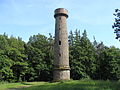
Ludwigsturm on the Blättersberg
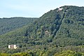
Rietburg with the aisle of the chairlift

Villa Ludwigshöhe; historical engraving

Kupperwolf Castle in Edesheim

Edesheim Castle

Erlenmühle east of Edesheim


The Haardtrand north of Hainfeld allows views from a height of 600 m over the German Wine Route to the Rhine plain, which is up to 500 m lower. Well-known viewpoints are the Ludwigsturm on the Blättersberg or the Rietburg , to which a chairlift leads up. Below the Rietburg, the summer palace Villa Ludwigshöhe was built for the Bavarian king in the 19th century . For the pilgrimage chapel of St. Anne on the southeast slope of the mountain devil lead from Burrweiler of processions of the Catholic Church.
Other attractions, Edesheim: the Church of St. Peter and Paul , the small, from the late Baroque originating Castle Kupperwolf and in the Middle Ages built and later converted water palace of the Prince Bishop of Speyer . Today it houses the Edesheim Castle Festival ; they also organize open-air performances on the floating stage at the castle pond, which is fed by the Modenbach.
traffic
In the Palatinate Forest, the Modenbach follows the district road 6 for the first 3.5 km , then the state road 506, which connects Ramberg with Weyher, to the edge of the mountains . In Edesheim, the Modenbach is crossed by the B 38 ( Landau - Neustadt ) and the Neustadt - Wissembourg railway line that runs between the two cities . The A 65 ( Karlsruhe - Ludwigshafen ) crosses the stream 1 km to the east . On the further course, the water in the Rhine plain crosses mainly meadows and arable land without any significant traffic routes.
On Sundays, bus route 506 runs from Edenkoben train station to the Modenbach valley. There are many hiking opportunities there.
Web links
Individual evidence
- ↑ a b Topographic map 1: 25,000.
- ↑ a b Rhineland-Palatinate Water Management Authority.
- ^ Name of the upper course
- ↑ Water status report 2010 , State Office for the Environment, Water Management and Trade Inspectorate Rhineland-Palatinate
- ↑ Around the Modenbachtal. outdooractive, accessed on January 8, 2015 (example: circular hike).