
Riser head
| Riser head
Schänzel
|
||
|---|---|---|
 Steigerkopf with Schänzelturm in February 2012 |
||
| height | 613.6 m above sea level NHN | |
| location | near Edenkoben , district of Südliche Weinstrasse , Rhineland-Palatinate ( Germany ) | |
| Mountains | Palatinate Forest | |
| Coordinates | 49 ° 17 '49 " N , 8 ° 1' 34" E | |
|
||
| rock | Red sandstone | |
| particularities | - Historic jumps on the slope - observation tower on the summit |
|

The Steigerkopf , popularly also called Schänzel , near Edenkoben in the Rhineland-Palatinate district of Südliche Weinstrasse is 613.6 m above sea level. NHN high mountain in the Palatinate Forest . The Schänzelturm stands on the summit, which is part of the Gommersheim forest area .
Geographical location

The Steigerkopf is located in the Palatinate Forest Nature Park in the eastern part of the eponymous low mountain range. Its peak rises about 7 km west-northwest of the town of Edenkoben on the western edge of a group of mountains, all of which are over 600 m high; 4 km to the northeast is the highest mountain in the Palatinate Forest, the Kalmit ( 672.6 m ).
The summit of Steigerkopf and especially to the northeast of it belong to the forest area of Gommersheim, which is an exclave around 17 km west of this local community. Geologically, the Steigerkopf represents the north-west runner of the 661.8 m high Kesselberg , whose summit is 2 km (as the crow flies ) away.
The Modenbach , a right tributary of the Speyerbach , rises on the southwest flank of the mountain on which the Gommersheimer Wald lies . East of the mountain is the source of the Triefenbach .
history
Schänzel
The Steigerkopf is also popularly called "Schänzel" since around 4500 Prussian soldiers erected several entrenchments there during the First Coalition War against France in the summer of 1794 . They were supposed to stop the French revolutionary troops, numbering 7,000 , who were preparing to conquer the German territories on the left of the Rhine . In the losing battle on July 12 and 13, 1794, the French won after being led into the rear of the Prussians on the second day by a local hunter from the nearby community of Dernbach . The Prussian commander General Theodor Philipp von Pfau (1727–1794) was seriously wounded in captivity and died on the same day.
Schänzelturm
In memory of the defeated Prussians, a hundred years after the event and in the awareness of the Franco-Prussian War won in 1871, the Schänzelturm was built on the mountain top . This is an octagonal observation tower that is 13 m high and was built from red sandstone . The viewing platform on the tower roof is secured by a railing.
The observation tower was dedicated in 1894 by the Schänzelturmverein zu Edenkoben:
"In memory of the brave Prussian warriors who died here in the battle against the French invasion army on July 13, 1794 for the German fatherland "
Dedications
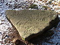
As early as 1796, the Austrian General Field Marshal Dagobert Graf von Wurmser had a memorial built for General von Pfau on the Steigerkopf. The so-called hero stone bears the following partially rhymed inscription:
“ The royal Prusian lord general von Pfau who remained in front of the enemy in 1794. / Known as a hero and honest man / Pfau died for the German fatherland. / As a friend of noble bravery / this monument is dedicated to him. / From the k. k. General Field Marshal Dagobert Count von Wurmser 1796 "
As an additional reminder of the battles of 1794, the knight stones with the numbers 62 to 68 were erected on the Steigerkopf in the 20th century .
Transport links
The access to the Steigerkopf is via an approximately 10 km long road that leads from Edenkoben (there as Klosterstraße) north parallel to the Triefenbach up to the west-northwest, curves around the summit and then goes down through the Modenbach valley in a south-easterly direction to Burrweiler . It overcomes more than 400 meters of altitude twice and is classified as a "particularly scenic route".
Picture gallery

Schänzelturm in November 2007

Schänzelturm in spring 2011

Schänzelturm in summer 2014
Memorial stone Inf.-Reg. von Schladen , June 25, 1794
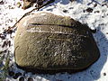
Ritterstein 64a To Schanze III

Inscription stone of the Prussian troops encamped here


literature
- Walter Eitelmann : Knight Stones in the Palatinate Forest . 4th, revised and significantly expanded edition. Palatinate Forest Association, Neustadt / Weinstr. 1998, ISBN 3-00-003544-3 .
- Heimatverein Venningen: 7. Under the rule of the French . In: Letter to Members No. 31 . Venningen October 31, 1989.
- Bernhard von Poten : Pfau, Theodor Philipp v. In: Allgemeine Deutsche Biographie (ADB). Volume 25, Duncker & Humblot, Leipzig 1887, p. 610 f.
Individual evidence
- ↑ a b Topographic map of the LANIS: Steigerkopf. On: map1.naturschutz.rlp.de, accessed on January 26, 2017 .
- ↑ Landscape information system of the nature conservation administration.
- ↑ a b c Heimatverein Venningen: 7. Under the rule of the French. (No longer available online.) In: Membership Letter No. 31 October 31, 1989, pp. 3–5 , archived from the original on February 22, 2014 ; Retrieved October 26, 2010 . Info: The archive link was inserted automatically and has not yet been checked. Please check the original and archive link according to the instructions and then remove this notice.
- ↑ Bernhard von Poten: Pfau, Theodor Philipp v. In: Allgemeine Deutsche Biographie (ADB). Volume 25, Duncker & Humblot, Leipzig 1887, p. 610 f.
- ↑ Memorial plaque on the Schänzelturm.
- ↑ Walter Eitel man: Ritterstein in the Palatinate Forest , Neustadt 1998th
- ↑ The General Map No. 15, Mairs Geographischer Verlag / Falk Verlag, Ostfildern, 2004.