Albersweiler
| coat of arms | Germany map | |
|---|---|---|

|
Coordinates: 49 ° 13 ' N , 8 ° 2' E |
|
| Basic data | ||
| State : | Rhineland-Palatinate | |
| County : | Southern Wine Route | |
| Association municipality : | Annweiler am Trifels | |
| Height : | 165 m above sea level NHN | |
| Area : | 10.85 km 2 | |
| Residents: | 1947 (Dec. 31, 2019) | |
| Population density : | 179 inhabitants per km 2 | |
| Postal code : | 76857 | |
| Area code : | 06345 | |
| License plate : | SOUTH | |
| Community key : | 07 3 37 001 | |
| LOCODE : | DE ILE | |
| Community structure: | 2 districts | |
| Association administration address: | Messplatz 1 76855 Annweiler am Trifels |
|
| Website : | ||
| Local Mayor : | Ernst Spieß ( SPD ) | |
| Location of the local community of Albersweiler in the southern Weinstrasse district | ||
Albersweiler is a municipality in the Südliche Weinstrasse district in Rhineland-Palatinate . It belongs to the Verbandsgemeinde Annweiler am Trifels , within which it is the second largest local community in terms of the number of inhabitants and the one furthest to the east.
geography
location
The place Albersweiler is about 170 m above sea level. NHN in a depression between the Haardt and the Wasgau , as the southern part of the Palatinate Forest and the adjoining northern part of the Vosges are also called, in the so-called Annweiler-Albersweiler-Ausraum , which is alternatively known as Trifelsland . The place has an extension of about 1.3 kilometers in north-south and east-west directions. The “Albersweiler Wald” exclave is located about 10 km northwest of the village . Of the total area of 10.85 km², 73% is forest. The mineral agate occurs in Albersweiler .
Elevations and waters
South of the Kirchberg , which extends on the southwestern edge of the settlement area, there is a 418 meter high elevation.
The Queich flows through the settlement area in a west-east direction. First it takes the Winterbach from the left and the Schwelterbach from the left within the built- up area. In the north-west, the brook runs from the Langenscheiderhof in a westerly direction, which flows into the Eisbach beyond the municipal marker . The Dernbach runs along the north-western edge of the district . The forest enclave Albersweiler Wald is bounded in the west by the Wellbach . With the Freimersheimertalbach , the outflow of the Husarenbrunnen and the Großer Fischbach, three left tributaries of the latter run through their area .
Neighboring communities
The following places are clockwise neighboring communities of Albersweiler; in brackets the approximate distance (as the crow flies) from the locality of Albersweiler: Frankweiler (2.4 km), Siebeldingen (2 km), Birkweiler (1.5 km), town of Annweiler am Trifels (4.5 km) with the district Queichhambach (2.5 km) and Dernbach (3.6 km). The "Albersweiler Forest" borders the city forest of Landau in the Palatinate , forest areas of Frankweiler and Siebeldingen and the "Annweiler city forest". All the forests mentioned are exclaves .
Community structure
The community consists of the main town of Albersweiler and the district of Sankt Johann ; structurally, both have now grown together. To Albersweiler includes the residential places Langenscheiderhof in the northwest of the municipal area and brick hut in the southeast near the border to Birkweiler.
history
middle Ages
It is uncertain whether documents from the 11th century refer to Albersweiler or places with a similar name. Samuel, Abbot of Weißenburg Monastery , bequeathed several servants' farms bought with his own money to the monastery in 1065, including one in Adelbreddesuuilare or Albrahteswilre . The receipt was used for Albersweiler, but also for Waldprechtsweier in Baden . The year 1065 is not certain either.
An Eberhardus de Adelbrahteswilre or Alb Dreheswilre attested to a document from the Eusserthal monastery , which was set by the first publisher in the year 1150, was listed twice elsewhere for 1150 and 1173-78 and ultimately dates from the years 1173-76. This document is often related to Albersweiler.
The town of Annweiler had held the southern part of Albersweiler since 1219, but was gradually ousted from these rights by the town of Landau . Landau, imperial town since 1274 and in competition with Annweiler, was able to use the quarry in Albersweiler after 1300, but also to use the mayor and the village court. Albersweiler had become a "town village" of Landau. In 1382 the Urnsburg is mentioned, of which little is known.
The southern part of the village fell through a pledge in 1330 to the Electoral Palatinate , in 1410 and 1444 through inheritance to Pfalz-Zweibrücken . The northern part of the village with today's district of St. ohann came to the von Scharfenberg family, after their extinction to the house of Löwenstein-Scharfeneck. Albersweiler was thus divided between two gentlemen and the main street of the village formed the border.
Early modern age
During the Reformation the confessional border was added, because the respective rulers determined the religion of their subjects, and a change of denomination in the ruling house also required this from the people. During the Thirty Years' War the Catholic troops burned down the Protestant southern part of the village in 1622. After the also Protestant counts of Löwenstein-Scharfeneck, who were local lords of the northern part of the village St. Johann, died out, in 1634 the emperor transferred this property to Count Johann Dietrich from the related, Catholic, later ducal family branch Löwenstein-Wertheim-Rosenberg . Until the French occupation in 1794, it was the "capital" of the Löwenstein lordship on the left bank of the Rhine, Scharfeneck , which comprised only a few villages and was ruled initially by Wertheim am Main , then from Löwenstein Castle in Kleinheubach . The princes of Löwenstein-Wertheim-Rosenberg let in Albersweiler-St. Johann built the rococo-style official palace that has been preserved to this day as the administrative seat (now the BASF study house). This Catholic district of Löwenstein was destroyed in 1634 by the Swedes fighting on the Protestant side. In 1645 the southern part of Zweibrücken was almost completely depopulated, in 1651 we read about the northern part of Löwenstein that it was "completely deserted and desolate".
After the Peace of Westphalia , the population increased only slowly , also due to several plague epidemics , and only after the War of the Spanish Succession , which meant above all contributions and billeting for the Albersweiler , the village was able to grow again. In 1736 the Lutheran church was built and in 1764 the foundation stone was laid for the aforementioned Löwensteiner official castle in St. Johann. During the First Coalition War , a battle took place on site.
Since the 19th century
After the French Revolution , the French occupied the entire area on the left bank of the Rhine in 1794 , for Albersweiler this meant the introduction of the achievements of the revolution and the abolition of the old order. Albersweiler became an independent commune within the canton of Annweiler , which belonged to the arrondissement of Zweibrücken in the French department of Donnersberg (Mont-Tonnerre) and was the seat of its own mairie , which also included Dernbach and Leinsweiler . After the Congress of Vienna in 1815, the place was added to Austria . Just one year later, the place, like the entire Palatinate, changed to the Kingdom of Bavaria . From 1818 to 1862 Albersweiler belonged to the Land Commissioner Bergzabern ; from this the district office Bergzabern emerged. The village showed itself in the 19th century as a farming village, which was mainly characterized by viticulture. The sales opportunities for local businesses were improved by the full length of the Landau – Zweibrücken railway line, which opened in 1875. In 1910 a water pipe was laid and in 1925 the installation of the local electricity network was completed.
From 1939 Albersweiler was part of the Bergzabern district . During the Second World War , the town center was bombed several times by Allied aircraft because a railway gun was stationed in the railway tunnel below the Bergkirche. In the post-war years the damage was repaired, in 1954 and 1955 the community built a canal system and new residents could be won by designating new building areas. After the war, the place within the French occupation zone became part of the then newly formed state of Rhineland-Palatinate. During the first Rhineland-Palatinate administrative reform moved Albersweiler in the newly created on June 7, 1969 the district Landau-Bad Bergzabern, in 1978 in South County Wine Trail is renamed . In 1972 the community was assigned to the also newly formed association community Annweiler am Trifels . In 1978 the municipal kindergarten was inaugurated.
population
Population development
The development of the population of Albersweiler, the values from 1871 to 1987 are based on censuses:
|
|
religion
In 1865 the Jewish community in Albersweiler built a synagogue , which was set on fire in 1938.
In 1832 the citizens built a Catholic schoolhouse, and in the same year the Protestant schoolhouse was moved into. The Catholic parish church of St. Stephan was built in 1843/45, and the Protestant mountain church in 1846. Both churches were planned by the well-known Bavarian architect August von Voit .
The Catholics belong to the Diocese of Speyer and are subordinate to the Landau deanery , the Evangelicals to the Protestant Church of the Palatinate . In 2012, 45.2 percent of the population were Catholic and 34.8 percent Protestant . The rest belonged to another religion or were non-denominational .
politics
Municipal council
The municipal council in Albersweiler consists of 16 council members, who were elected in a personalized proportional representation in the local elections on May 26, 2019 , and the honorary local mayor as chairman.
The distribution of seats in the municipal council:
| choice | SPD | CDU | LFW | Green | total |
|---|---|---|---|---|---|
| 2019 | 7th | 5 | 2 | 2 | 16 seats |
| 2014 | 9 | 5 | 2 | - | 16 seats |
| 2009 | 7th | 7th | 2 | - | 16 seats |
| 2004 | 8th | 7th | 1 | - | 16 seats |
mayor
Ernst Spieß (SPD) has been the local mayor of Albersweiler since 1994. He was last re-elected for another five years in May 2019 with a share of 75.34% of the vote.
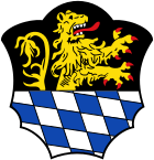
coat of arms
|
Blazon : "In a divided shield above in black a growing left-turned, red-armored and tongued golden lion, roughened with silver and blue below."
It was approved in 1937 and dates back to a seal from 1531. |
|
Culture
Cultural monuments
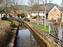
The Albersweiler Canal , the town center and the Löwenstein Castle are designated as monument zones.
In addition, there are a total of 19 individual objects that are under monument protection , including the Protestant parish church, which is sometimes referred to as the "mountain church".
nature
The entire municipality - including the area beyond the Palatinate Forest with buildings and surrounding vineyards - is part of the Palatinate Forest Nature Park , which in turn belongs to the cross-border Palatinate Forest-Vosges du Nord Biosphere Reserve . To the southwest of the village is the Haardtrand nature reserve - Auf dem Kirchberg , north of the main town is the smaller Haardtrand - Auf dem Schoeb nature reserve . In the north-east, the Haardtrand - Käfernberg nature reserve extends partly on the Albersweiler district; the largest part already belongs to Frankweiler.
societies
There is the women's handball team SG Albersweiler-Hauenstein-Ranschbach , which took part in the DHB Cup in 2009.
Infrastructure
economy
Towards the end of the 19th century, Albersweiler grew into an industrial location and the Richard Haupt match factory , a porcelain factory, a “sulfur kitchen”, a glove factory and a shoe factory were established there. The measuring instrument manufacturer Stabila temporarily had a plant on site.
At the western exit of the village is a gneiss quarry owned by the Basalt-Actien-Gesellschaft , which was one of the most important Albersweiler jobs in the 19th century. In addition, the community is the seat of the Sinti workshop , which created the memorial for the deported and murdered Sinti and Roma from Wiesbaden .
In addition, Albersweiler is part of the Palatinate wine-growing region . The single layer Latt is located on site . The vineyards are to the east and south of the development.
traffic
Between 1687 and 1975 there was the originally navigable Albersweiler Canal between Albersweiler and Landau. The Landau – Rohrbach railway has been connecting Albersweiler to the rail network since 1874; the original station was located in the then independent community Queichhambach and was abandoned in 1984 in favor of a local stop located around 300 meters to the east. To the east of this station, the route crosses the Kirchberg tunnel . Albersweiler is also connected to the local public transport network via bus line 521 in the Rhein-Neckar transport association.
In 1984, with the inauguration of the bypass of the federal highway 10, the last very heavy traffic load was removed from the place. Since then this has been running south of Albersweiler towards Landau in der Pfalz and Annweiler am Trifels . State road 507 , which leads to Speyer , also runs through the settlement area .
tourism
The path, one of the so-called Saar-Rhein hiking trails, with the marking Schwarzer Punkt on a white bar , runs through Albersweiler and leads from Saarbrücken to Rülzheim . The Staudernheim-Soultz-sous-Forêts long-distance hiking trail marked with a blue bar leads through the northeast of the forest enclave for a short stretch . The community is also the starting point for Tour 7 of the Palatinate Forest Mountain Bike Park . The district of Sankt Johann acts as the starting point for the Palatinate hut tour .
Personalities
Born in Albersweiler
- Adam Konrad Boeninger (1810–1886), printer and publisher
- Andreas Flocken (1845–1913), entrepreneur
- Gottlob Friedrich Lipps (1865–1931), philosopher and psychologist
- Artur Schmitt (1888–1972), politician (NPD)
- Hellmut Culmann (1898–1949), pastor, local poet from the Palatinate
Associated with Albersweiler
- Karl Thomas zu Löwenstein-Wertheim-Rochefort (1714–1789), third prince from the Löwenstein family, had the Löwenstein Castle built in 1764
- Klara Barth (1880–1940), politician (BVP), worked on site at times as a teacher
- Ludwig Marum (1882–1934), lawyer and politician (SPD), married on site in 1910
- Adolf Kessler (1890–1974), painter, designed the mural for the match factory in 1951
literature
- Karl Hamm: Albersweiler. Contributions to the millennial history of a Palatinate village. Municipal administration, Albersweiler 1969.
- Hans Bosch (written): 1000 years of Albersweiler-St. Johann. 991-1991. Local chronicle for the 1000th anniversary. Holidays from 2nd to 12th August 1991. Parish, Albersweiler – St. Johann 1991.
Web links
- Official website of the local community Albersweiler
- Literature about Albersweiler in the Rhineland-Palatinate state bibliography
Individual evidence
- ↑ State Statistical Office of Rhineland-Palatinate - population status 2019, districts, communities, association communities ( help on this ).
- ↑ a b State Statistical Office Rhineland-Palatinate - regional data
- ↑ State Statistical Office Rhineland-Palatinate (ed.): Official directory of the municipalities and parts of the municipality. Status: January 2019 [ Version 2020 is available. ] . S. 158 (PDF; 3 MB).
- ↑ rhein-zeitung.de of February 16, 2012
- ^ Report of the Pirmasenser Zeitung . On the other hand, see Martin Burkart: On the first documentary mention of Albersweiler. In: Pfälzer Heimat 64 (2013) 54–58
- ^ Ernst Christmann: The settlement names of the Palatinate , part 1, 1st delivery, Speyer 1953, p. 6
- ↑ The year is based on the information in the Codex Edelini , which historians consider to be unreliable. National Archives director Anton Doll, a profound knowledge of Weißenburger history, characterizes him as "sometimes very unreliable late compilation of older property lists" and warns almost before its exploitation as a source for the early period of local stories (ibid: Newer Wittlich stories . In: Palatine home 15 (1964) 34–36, here p. 36.)
- ↑ Stephan Alexander Würdtwein : Nova subsidia diplomatica , Vol. 12, Heidelberg 1789, p. 91
- ↑ Martin Dolch, Albrecht Greule : Historisches Siedlungsnamesbuch der Pfalz . Speyer, Publishing House of the Palatinate Society for the Advancement of Science 1991, p. 31
- ↑ Jürgen Keddigkeit et al. (Ed.): Palatinate Monastery Lexicon , Volume 1, AE, Eußerthal, p. 408
- ↑ rlpdirekt.de municipal statistics. As of October 31, 2012.
- ^ The Regional Returning Officer Rhineland-Palatinate: Municipal elections 2014, city and municipal council elections
- ^ SPD Albersweiler: Our candidate for mayor. (PDF)
- ^ The Regional Returning Officer of Rhineland-Palatinate: direct elections 2019. see Annweiler am Trifels, Verbandsgemeinde, second line of results. Retrieved April 13, 2020 .
- ^ Karl Heinz Debus: The great book of arms of the Palatinate. Neustadt an der Weinstrasse 1988, ISBN 3-9801574-2-3
- ↑ General Directorate for Cultural Heritage Rhineland-Palatinate (ed.): Informational directory of cultural monuments - Southern Wine Route district. Mainz 2020, p. 3 f. (PDF; 10 MB).


