Waldprechtsweier
Waldprechtsweier has been part of the municipality of Malsch in the Karlsruhe district since April 1, 1972 .
history
The name Waldprechtsweier goes back to a personal name and the suffix -wilari (= hamlet).
First documentary mention
A document from the second half of the 11th century on the occasion of a donation from Abbot Samuel to the Weissenburg Monastery is partially claimed for Waldprechtsweier. Two slightly different certificates have been received about this donation. According to the note contained in the Nekrologium of the Weißenburg monastery, there were four courtyards in "Bugcheneshem", one and a half courtyards in "Malsca" (Malsch), which were subject to interest on the feast of Saints Sergius and Bacchus , and one courtyard in "Adelbreddesuuilare". According to a text around 200 years younger, the Liber Possessionum by Abbot Edelin, it was farms in “Bugenesheim”, “Malsche” and “Albrahteswilre”. However, the older testimony does not contain the exact year in which Samuel's donation took place. The often mentioned year 1065 is based on the more recent Liber Possessionum , which historians consider to be unreliable. Since the first text is older and contains more detailed information, it is preferable in terms of textual criticism. It is unclear whether "Adelbreddesuuilare" means Waldprechtsweier or the Palatinate town of Albersweiler . Waldprechtsweier was mentioned as "Walpendeteswiler" in 1271, when the brothers Bertold, Egelof, Sigfrid and Andreas von Elchesheim sold part of the Waldprechtsweier tithe they owned to the Herrenalb monastery .
Further historical development
On the district was the Burgwald Rock , the seat of the Earls of Malsch. This was sold to the Herrenalb monastery by the margraves of Baden in 1318 and soon fell into disrepair. However, the village of Waldprechtsweier remained in Baden and fell to Rudolf when the margraviate was divided in 1388 between Bernhard I and Rudolf VII .
The always small congregation was apparently able to build its own church for the first time in the early 18th century, because in 1727 there is talk of an "erbawten chapel", which was not yet consecrated at the time. In 1766 the community asked for permission to "demolish their little chapel ... which is quite ruinous and too small ... and to rebuild it". In fact, a new church dedicated to St. Michael was built in 1769, which was replaced by the current church in 1930.
Waldprechtsweier had only 11 families in 1683 and belonged to the Kuppenheim office , later to the Rastatt district . On April 1, 1972, the place lost its independence when it was incorporated into Malsch and has since been part of the Karlsruhe district .
Worth mentioning is the Battle of Malsch , which took place here as part of the First Coalition War in 1796.
On November 2, 1982, a convoy of four Pershing rocket tugs accidentally drove on the steeply sloping county road in Freiolsheim , whereupon three of the vehicles got out of control because the brakes had failed. One of the vehicles rolled over an oncoming car. The driver of the car was killed. Due to the risk of explosion, the site was evacuated for around twelve hours during the rescue.
Culture and sights
The Waldprechtsbach flows through the community .
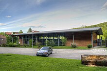
In 2003/04 a new multi-purpose hall was built in Talstrasse.
Personalities
The politician Gustav Trunk (1871-1936), who was President of Baden from 1920-1921, 1925-1926 and 1927, comes from Waldprechtsweier .
literature
- The art monuments of Baden Volume 12: Landkreis Rastatt. Edited by Peter Hirschfeld, with the assistance of E. Lacroix and H. Niester, with contributions by A. Dauber and O. Linde, revised and supplemented by Hans Huth. Karlsruhe 1963. pp. 362-364
Web links
Individual evidence
- ↑ late 11th century; as “Codex Weissenburgensis 45” today in the Herzog August Library Wolfenbüttel; fol. 182. Edited by Ernst Friedrich Mooyer: Nekrologium des Weißenburg Monastery, with explanations and additions. In: Archive of the historical association of Lower Franconia and Aschaffenburg 13 (1855) 1-67, on donation p. 43 ff.
- ↑ Today in the Landesarchiv Speyer, signature F 2 No. 147, fol. 55. Edited by Johann Kaspar Zeuss: Traditiones possessionesque Wizenburgenses. Speyer, 1842. Here p. 303
- ↑ National Archives director Anton Doll, a profound knowledge of Weißenburger history, characterizes him as "sometimes very unreliable late compilation of older property lists" and warns almost before its exploitation as a source for the early period of local stories (ibid: Newer Wittlich stories . In: Palatine home 15 (1964) 34-36. Here: p. 36.)
- ↑ On the question of the first mention of Martin Burkart: On the first documentary mention of Albersweiler . In: Pfälzer Heimat 64 (2013) 54-58.
- ↑ The text of the certificate is published at http://www.wubonline.de/?wub=3024
- ^ Federal Statistical Office (ed.): Historical municipality directory for the Federal Republic of Germany. Name, border and key number changes in municipalities, counties and administrative districts from May 27, 1970 to December 31, 1982 . W. Kohlhammer, Stuttgart / Mainz 1983, ISBN 3-17-003263-1 , p. 476 .
-
↑ Source for the section on the Pershing accident:
Brakes fail . In: Der Spiegel . No. 45 , 1983, pp. 31 f . ( spiegel.de ).
Coordinates: 48 ° 52 ' N , 8 ° 20' E


