Wellbach (Queich)
| Wellbach | ||
|
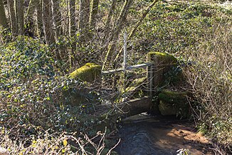
Weir on the Wellbach |
||
| Data | ||
| Water code | DE : 237722 | |
| location | Rhineland-Palatinate , Germany | |
| River system | Rhine | |
| Drain over | Queich → Rhine → North Sea | |
| source | at the Eschkopf in the Palatinate Forest 49 ° 18 ′ 33 ″ N , 7 ° 52 ′ 1 ″ E |
|
| Source height | approx. 490 m above sea level NHN | |
| muzzle | at Rinnthal coordinates: 49 ° 13 '27 " N , 7 ° 54' 52" E 49 ° 13 '27 " N , 7 ° 54' 52" E |
|
| Mouth height | approx. 192 m above sea level NHN | |
| Height difference | approx. 298 m | |
| Bottom slope | approx. 23 ‰ | |
| length | approx. 12.8 km | |
The Wellbach is a brook in the Palatinate Forest , which, after almost 13 kilometers in total approximately south-south-east, flows into the upper Queich from the left just before Rinnthal .
course
The Wellbach rises at the eastern foot of the Eschkopf ( 608.3 m above sea level ) at around 490 m and flows in south to south-east directions. He passes Hofstätten , which, as a district and northern community exclave of Wilgartswiesen, is located on the right in a cleared island, while the associated residential area Häusel with two or three houses is close to the right lower slope. This is in addition to the Landauer living space Grasp pond less than half a kilometer down the left slope of the only settlement place in the otherwise uninhabited valley to the inlet of the Kaltenbachs remains forested and on the ground. There, after about three quarters of the run, a broad meadow floodplains now below 210 m .
After the Wellbach has finally passed under the federal highway 10 ( Pirmasens - Landau ), it flows less than half a kilometer above the local boundary of Rinnthal from the left into the upper Queich , of which it is the strongest tributary.
The federal road 48 ( Johanniskreuz –Rinnthal) follows the entire course of the stream.
In its upper reaches, the Wellbach is partly the boundary of the city of Landau, which has extensive forest areas in the Palatinate Forest.
Tributaries
Direct tributaries from the source to the mouth. Selection.
- Brook from the Mosistal , from the right, approx. 1.5 km
- Brook from the Mosisbruch , from the right, approx. 0.8 km
- Hedge pond, from the left, approx. 0.4 km
- Flachsbach , from the right, approx. 2.9 km
- Wolf pond, from the right, approx. 0.5 km
- Langeckbach, from the left, approx. 0.9 km
- Freimersheimertalbach , from the left, approx. 2.3 km
- Outflow of the Hussar Well , from the left, approx. 0.2 km
- Eiderbach , from the right, approx. 2.4 km
- Großer Fischbach , from the left, approx. 0.9 km
- Small Fischbach , from the left, approx. 1.1 km
- Rotsuhlbach, from the right, approx. 0.3 km
- Kaltenbach , from the right, approx. 5.7 km
- Freischbach , from the right, approx. 5.7 km
- Langenbächel , from the left, approx. 1.8 km
Web links
- Map of the course and catchment area of the Wellbach on: Map service of the landscape information system of the Rhineland-Palatinate Nature Conservation Administration (LANIS map) ( notes )
Individual evidence
- ↑ GeoExplorer of the Rhineland-Palatinate Water Management Authority ( information )
- ↑ Lengths measured on the map service of the landscape information system of the Rhineland-Palatinate nature conservation administration (LANIS map) ( notes )
