Hofstätten (Wilgartswiesen)
|
Farmsteads
Local community Wilgartswiesen
Coordinates: 49 ° 16 ′ 47 " N , 7 ° 51 ′ 38" E
|
||
|---|---|---|
| Height : | 425 m above sea level NHN | |
| Residents : | 109 (December 31, 2015) | |
| Postal code : | 76848 | |
| Area code : | 06397 | |
|
Location of Hofstätten in Rhineland-Palatinate |
||
|
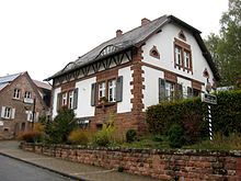
The village of Hofstätten
|
||
Hofstätten is a part of the local community Wilgartswiesen in the district of Südwestpfalz in Rhineland-Palatinate .
geography
location
Hofstätten is located in the Palatinate Forest-Vosges du Nord biosphere reserve in the so-called Frankenweide . The area around the place forms an exclave of the municipality Wilgartswiesen, which lies north of the rest of the municipality. The residential area Häusel also belongs to the district of Hofstätten .
Elevations and waters
The settlement area is located on the right above the Flachsbachtal , a right, western side valley of the upper Wellbachtal . The latter also forms the eastern border of the exclave. Immediately to the west of the development, the 558.9 m above sea level extends . NN high Blosenberg . The highest point is the 608.3 m above sea level. NN high Eschkopf in the north of the exclave, a good three kilometers north of the actual place, where the Erlenbach rises in addition to the Wellbach , the strongest source brook of the Speyerbach . The Mosisberg one kilometer further south measures 608.7 m above sea level. NN .
history
There is no information about the origins of the place. It was first mentioned in 1379; it was created primarily as a base for forest workers. From 1560 a parish and its own church are secured. The place was destroyed in the Thirty Years War and remained uninhabited until 1665. In 1665 the Counts of Leiningen built a dairy in Hochstetten . A manorial estate and forest farmhouses were also built. Until the end of the 18th century, the place formed a condominium , as it belonged jointly to Zweibrücken and the Leiningern .
During the First Coalition War , Hofstätten was captured by the French in 1794 and partially destroyed. During this time, Hofstätten was merged with Wilgartswiesen further south to form one community. This status has not been changed since then. In the first half of the 19th century a forester's house was built by the Bavarian forest administration. During this time the place was sometimes called "Hochstätten". In 1926 a new church was built for the church that was destroyed in 1635. 1931 so far has been Wilgartswiesen-Hofstätten hot congregation in Wilgartswiesen renamed. On January 1, 1976, the places Speyerbrunn , Erlenbach and Schwarzbach , which had previously been in the Hofstätten district , were added to the neighboring municipality of Elmstein and the eastern part of the hamlet of Johanniskreuz fell to Trippstadt , to which the western part of the village had previously belonged.
politics
The district of Hofstätten is one of the two local districts of the local community Wilgartswiesen and has its own local advisory board and a local councilor .
The local advisory council consists of six members who were elected by a majority vote in the local elections on May 26, 2019 , and the honorary mayor as chairman.
Peter Bernhard became mayor of Hofstätten for the first time on September 11, 2014. Since there was no applicant in the direct election on May 26, 2019, the upcoming election of the mayor was made by the local advisory board. This confirmed Bernhard in June 2019 for another five years in his office. Bernhard's predecessor Edwin Jacobs had held the office for 15 years.
Culture
Cultural monuments
With the Protestant church, a forester's lodge, the north of the settlement area located Eschkopf tower and a memorial stone dedicated to a forester, located on-site total of four properties under conservation are.
media
The 2013 film Lost Place was shot in the Hofstätten district.
Economy and Infrastructure
economy
For centuries Hofstätten was shaped by forestry. With the Hofstätter-Scheune-Bräu, there has been a brewery on site since 2008 that produces the light and dark varieties as well as seasonal Märzen, Festbier and Nikolausbier.
traffic
Hofstätten can be reached via the B 48 , which follows the Wellbach in this area. From this the district road 57 branches off , which connects the town center to the road network.
The place is connected to the local transport network via the bus line 526 of the transport association Rhein-Neckar , which leads to Annweiler am Trifels, Wilgartswiesen and Hauenstein.
Hofstätten is also on the route of two hiking trails, one of which is marked with a blue-yellow bar and connects, among other things, with Lauterecken and Sankt Germanshof . The other is marked with a yellow bar and leads from Contwig to Germersheim .
Institutions
Hofstätten had had its own schoolhouse since 1847, which was also used for church services. Also in the area of Hofstätten is the only partially used radio relay site Langerkopf .
Web links
Individual evidence
- ↑ Homepage of the local congregation: The congregation introduces itself ...
- ^ The regional returning officer RLP: Local council election 2019 Hofstätten. Retrieved April 5, 2020 .
- ↑ Local Advisory Board: Peter Bernhard new mayor. Die Rheinpfalz, September 13, 2014, accessed on April 5, 2020 .
- ^ The Regional Returning Officer for Rhineland-Palatinate: direct elections 2019. see Hauenstein, Verbandsgemeinde, last line of results. Retrieved April 5, 2020 .
- ↑ Peter Bernhard remains mayor in Hofstätten. Die Rheinpfalz, June 28, 2019, accessed on April 5, 2020 .


