
Wilgartswiesen
| coat of arms | Germany map | |
|---|---|---|

|
Coordinates: 49 ° 13 ' N , 7 ° 53' E |
|
| Basic data | ||
| State : | Rhineland-Palatinate | |
| County : | Southwest Palatinate | |
| Association municipality : | Hauenstein | |
| Height : | 220 m above sea level NHN | |
| Area : | 58.35 km 2 | |
| Residents: | 997 (Dec. 31, 2019) | |
| Population density : | 17 inhabitants per km 2 | |
| Postal code : | 76848 | |
| Area code : | 06392 | |
| License plate : | PS , ZW | |
| Community key : | 07 3 40 057 | |
| LOCODE : | DE ZIU | |
| Association administration address: | Schulstrasse 4 76846 Hauenstein |
|
| Website : | ||
| Local Mayor : | Manfred Schoch | |
| Location of the local community Wilgartswiesen in the district of Südwestpfalz | ||
  |
||


Wilgartswiesen is the largest municipality in terms of its area in the district of Südwestpfalz in Rhineland-Palatinate . It belongs to the Verbandsgemeinde Hauenstein , within which it is its third largest local community in terms of population. Wilgartswiesen is a state-approved resort .
geography
Location and community structure
The core town is in the southern Palatinate Forest , the German part of the Wasgau , on its northern edge. The hamlet of Hermersbergerhof, 5 km to the north, at the foot of the Weißenberg, is the highest settlement in the Palatinate. Another district is the Hofstätten exclave , which is located north of the rest of the municipality.
The extensive area north of the core community, which largely belongs to the low mountain range of the Frankenweide , is almost entirely wooded outside of the residential buildings.

Hermersbergerhof district

Exclave Hofstätten


Neighboring municipalities are clockwise - including exclaves in italics - Annweiler am Trifels , Rinnthal , Spirkelbach , Hauenstein , Spirkelbach , Hinterweidenthal , Münchweiler an der Rodalb and Merzalben . The Hofstätten exclave borders in a clockwise direction on Elmstein , Landau in der Pfalz , Annweiler am Trifels , Merzalben, Leimen and Trippstadt .
Surveys

The 336.9 m high Schloßberg , the 457 m high Große Breitenberg , the Kleine Breitenberg ( 455.6 m ) and the Große Distel extend near the settlement . In the southwest, directly on the border with Hauenstein, are the 336.3 m high Neding and the 324 m high Mischberg . Northeast of the settlement area rises the 408 m high Göckelberg , whose eastern flank already belongs to Rinnthal.
To the west of the district are the Katzenkopf ( 553 m ), the Staufelkopf ( 552 m ), the Steckeneck and, immediately next to each other, the tip Boll ( 540.1 m ) and northeast of it the width Boll ( 528 m ). The Haseneck ( 467 m ) and the Große Boll ( 533 m ) join further to the west . Not far from the border with Hinterweidenthal are the 432 m high Große Horberg , the 404 m high Pfaffenberg and the 396 m high floodplain .
The 610 m high Mosisberg with its eastern part Langerkopf , the 558.9 m high Blosenberg , the 516 m high Saukopf and further north the 608.7 m high Eschkopf lie within the boundaries of Hofstätten .
Waters
The Queich , which forms one of the main drainage systems of the Palatinate , flows through the middle of the settlement area of the core town ; their upper valley lying in this area is a box valley. About a kilometer west of the settlement area is the Kohlwoog , which is also the source of an unnamed stream; the latter flows into the Queich from the left at the southern edge of the Wilgartswieser development. Further to the southeast, this takes on the Spirkelbach from the right .
The Freischbach runs to the northeast of the development . In the west of the district flows the Horbach , a left tributary of the Lauter and takes on several tributaries such as the Waldbach , the Bollgrabenden Bach from the Großer Spechtel , the Mautzenbach , the Hüttengraben and the Pfaffenbach ; the mouth of the latter is already beyond the municipal mark.
.jpg)
The Lauter source river Wartenbach runs in the northwest on the district boundary to Merzalben, which previously forms Scheidbach from its left tributary . Then the Lauter, which is called Wieslauter in its upper area, runs along the border to Münchweiler an der Rodalb. From the left it takes up the Lembach , which is located on the entire length of the Wilgartswiesen district.
Hermerbergerhofs southeast of the springs from the running to the east Modenbach , of about 2 km to the border to Rinnthal forms before it in the Kaltenbach opens. The latter rises north of the Hermersbergerhof and a little later forms the border to an exclave belonging to Annweiler am Trifels.
The Wellbach forms the eastern border of the Hofstätten exclave. The Flachsbach , a right tributary of the Wellbach, flows north and below the settlement area . The Erlenbach , which is hydrologically regarded as the actual source of the Speyerbach and which crosses the boundary to Elmstein after around 2 km, also rises on the boundary of the exclave .
geology
In addition, the community is the only known site in Germany for the rare mineral arcanite . Geologically, the Trifels layers dominate on site .
history

Wilgartswiesen was mentioned in a document as early as 828, when Countess Wiligarta from the family of the Gaugrafen des Bliesgau , the so-called Guidonen , donated the church and farm Willigarttawisa to the Hornbach monastery, which from then on drove the reclamation of the area and founded the Hermersbergerhof annex. This makes it the oldest community in Queichtal. Later the place and the extensive area were administered from the nearby Falkenburg . By the end of the 18th century, the community formed a condominium by jointly belonging to Zweibrücken and the Leiningen-Dagsburg line . During the subsequent French rule, Wilgartswiesen was merged with the Hofstätten further northeast to form one municipality.
From 1798 to 1814, when the Palatinate was part of the French Republic (until 1804) and then part of the Napoleonic Empire , Wilgartswiesen and Hofstätten - as they were called at the time - were incorporated into the canton of Annweiler and the seat of Mairie Wilgartswiesen , who also included Rinnthal and Spirkelbach included. In 1815 the municipality was added to Austria , and just one year later the municipality, like the entire Palatinate, changed to the Kingdom of Bavaria . From 1818 to 1862 Wilgartswiesen and Hochstätten were part of the Bergzabern Land Commissioner , which was then converted into a district office. On June 17, 1849 Wilgartswiesen was partially the scene of the battle near Rinnthal ; part of the Prussian associations remained behind the community.
In 1931 the community, previously called Wilgartswiesen-Hofstätten, was renamed "Wilgartswiesen". In 1939 it was incorporated into the Bergzabern district. After the Second World War , the municipality within the French occupation zone became part of the then newly formed state of Rhineland-Palatinate. In the course of the first administrative reform in Rhineland-Palatinate , the municipality moved to the district of Pirmasens in 1969 (from 1997 district of Südwestpfalz ) . Three years later it was incorporated into the newly created community of Hauenstein .
In 1972 the eastern part of the hamlet of Johanniskreuz was added to the municipality of Trippstadt , to which the western part had previously belonged. On January 1, 1976, the hamlet of Kaltenbach , which had previously belonged to the municipality, was reassigned to Hinterweidenthal and the villages of Speyerbrunn , Erlenbach and Schwarzbach, located in the Elmsteiner Valley , to Elmstein .
population
Population development
In 1815 the community had a total of 732 inhabitants. In the course of the assignment of the territory to the municipality of Elmstein, Wilgartswiesen lost a total of 207 inhabitants in the mid-1970s. In 2004, 1,190 people lived in Wilgartswiesen. In the period that followed, the number of inhabitants decreased further. In 2006 it was 1,115; since the 2010s it has stagnated at around 1,000.
religion
In 2012, 57.6 percent of the population were Protestant and 29.2 percent Catholic. The rest belonged to another religion or were non-denominational. The Catholics belong to the Diocese of Speyer , the Evangelicals to the Protestant Church of the Palatinate .
politics
Municipal council

The council in Wilgartswiesen consists of 16 council members, who in the local elections on May 26, 2019 in a majority vote were elected, and the honorary mayor as chairman.
The distribution of seats in the municipal council - due to the majority vote, it is not possible to present results according to parties and voter groups:
| choice | GREEN | BfW | total |
|---|---|---|---|
| 2019 | by majority vote | 16 seats | |
| 2014 | 3 | 9 | 12 seats |
| 2009 | 4th | 12 | 16 seats |
| 2004 | 4th | 12 | 16 seats |
- BfW = Alliance for Wilgartswiesen e. V.
mayor
As the successor to Jürgen Brödel, who was no longer running, the only applicant Manfred Schoch was elected mayor on May 26, 2019 with 76.3 percent of the vote and was appointed mayor on August 12, 2019.
coat of arms
|
|
Blazon : "In green a golden hunting spear growing diagonally to the right with the silver iron turned upwards."
The coat of arms was approved by the Bavarian State Ministry of the Interior in 1931 and goes back to a court seal from 1463. |
Culture and sights
Cultural monuments

Double tower church
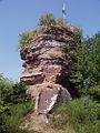
Falkenburg rock

Staircase on the Wilgartaburg

Ritterstein 57 Dreiherrenstein


The Wilgartaburg, which gives it its name, is designated as a monument zone .
In addition, there are a total of 21 individual monuments, including the Falkenburg, which was built as an imperial fortress in the 12th century, which was blown up in the Palatinate War of Succession and has been in ruins since then. The Protestant church built from the local red sandstone is the only two-tower church in the Palatinate Forest. In the north-west of the district, directly on the border with Merzalben, is the Dreiherrenstein , which is also designated as Ritterstein 57 . The Eschkopfturm stands 3 km north of the Hofstätten buildings .
nature

To the north of the village, there are many rock groups made of red sandstone, from which the Wilgartaburg and the Falkenburg, among others, are carved. The Falkenburg-Tiergarten nature reserve is located within the municipality . With the rock group Neding and the lower alluvial water source , the place has two natural monuments .
The 2400 hectare core zone of the Wieslauter headwaters of the Palatinate Forest Nature Park is also partly in the Wilgartswiesen area. As part of the nature park, the community is also part of the Palatinate Forest-Vosges du Nord biosphere reserve . In the west of the district there is also the Pfaffenberg natural forest reserve , which was designated in 1995 and covers 76 hectares, and the southern Palatinate Bergland Wilgartswiesen forest reserve . Wilgartswiesen is also part of the Palatinate Forest climbing area .
Knight stones

There are numerous knight stones on the parish of the municipality . Most refer to settlements and farms that once existed within the municipality of Wilgartswiesen. Ritterstein 38 Vogelshütte , which is located in the far west of the district in the Zieglertal and indicates a wadld farm that was laid down in 1855. 39 Kunzelmannsgut lies further south and marks a manorial estate first mentioned in 1613. 40 Granitzenhütte indicates the remains of a former farm. 45 R. Neu-Falkenburg is reminiscent of the short-lived Neu-Falkenburg Castle. 50 Wildsauhütte is the location of a former log cabin for forest workers. 52 Eussertal monastery property are located in the area of the Hermersbergerhof; he refers to its former affiliation to the Eusserthal monastery. 59 R. Wüstmühle marks the location of an earlier saw and grinding mill. 78 Mosisbruch is located in the area of the Hofstätten exclave and refers to the location of a Wadl farm, which was in the immediate vicinity of the high moor of the same name.
In addition to the already mentioned Ritterstein 57, the Ritterstein 46 zoo , which is located at the location of the zoo that belongs to the Falkenburg and now no longer exists, serves as orientation points for hikers . 53 Protected stands on private property within the hamlet of Hermersbergerhof and refers to juniper trees that no longer exist at its location. 224 Alte Straße - Falkenburger Steige 225 Ruts - Damm 226 Alte Straße - Celtic Age - Middle Ages - Ruts - Damm and 227 Old Street - Celtic Age - Middle Ages mark the course of no longer existing streets from prehistoric times.
The knight's stone with the number 48 marks a preserved wolf pit , in which a wolf was last killed in 1908, and number 49 the Wilgartaburg. 80 Preussenstein stands on the site of an earlier Prussian guard.
Countess Wiligarta
The “Countess Wiligarta” acts as the tourist representative.
Events
In 2018 the children's musical Freddy the Donkey was performed in Wilgartswiesen .
Economy and Infrastructure
economy
Due to the geographic conditions, forestry dominated the area for centuries. Wood processing is another important branch of the economy. The shoe industry has lost much of its former importance. After the Second World War, the place was also part of the Pirmasens Military Community, which has now been dissolved .
traffic
rail

The community received in 1875 following the railway network, as previously in Annweiler am Trifels ending Landau Zweibrücken railway line was opened to full length. The station was built on the south-eastern edge of the settlement. The service in the freight traffic ended in 1998. In the meantime it represents the only possible crossing between Annweiler and Hinterweidenthal . It is served by regional trains of the line RB 55 , which run between Landau and Pirmasens . The existing station building no longer plays a role for rail operations. The public transport system is in the transport association Rhein-Neckar integrated.
The Hauenstein Mitte stop , which was put into operation in 2010 and which serves to better develop Hauenstein, is also located in the Wilgartswiesen district; For this reason the community had resisted its construction for a long time, fearing for the continued existence of their previous station.
Street

Wilgartswiesen is located on federal highway 10 , which originally ran through the middle of the settlement area and which is now used as a bypass road around the local area. In the north of the Hofstätten district, the B 48 runs in the direction of Kaiserslautern and Bad Kreuznach . The county road 38 connects the community with Hauenstein and the county road 54 with Spirkelbach and Schwanheim . The district road 56 connects the Hermersbergerhof to the road network and the district road 57 Hofstätten.
In addition, the bus line 526 of the Rhein-Neckar transport association runs through Wilgartswiesen, which connects the town and Hofstätten with Annweiler am Trifels and Hauenstein.
Institutions
In the district of Hermersbergerhof there is the Pfälzerwald specialist clinic , which is sponsored by the Evangelical Home Foundation Palatinate .
tourism

In the forests of the Frankenweide, the Palatinate Forest Association maintains an extensive network of markings for cyclists and hikers. The Pfälzer Waldpfad hiking trail runs through Wilgartswiesen, but away from the settlement area . The community is on the route of a hiking trail that is marked with a blue-yellow bar and connects with Lauterecken and Sankt Germanshof , among other places . There is also one that is marked with a yellow-red bar and one with a blue cross that runs through both the core town and the hamlet of Hermersbergerhof.
The hamlet of Hermersbergerhof is located on the Höcherbergweg , which runs from Niederwürzbach to Böchingen and which is marked with a red and white bar . One of them, marked with a yellow bar and running from Contwig to Germersheim , leads through Hofstätten and the Franconia-Hesse-Kurpfalz long-distance hiking trail marked with a red cross . The path marked with a blue-red bar connects both Hofstätten and Hermersbergerhof and leads from Kirchheimbolanden to Pirmasens .
In addition, Wilgartswiesen is the eastern end point of the Pirminius cycle path , which starts in Hornbach . In addition, the Queichtal cycle path runs through the municipality. The Palatinate Forest tour , which runs from Kaiserslautern to Hinterweidenthal, leads through the far west of the municipality marker.
Personalities
Sons and daughters of the church
- Albert Buchmann (1888– ~ 1942), SS leader and police officer
Other personalities
- August Grub was the chief of the local fire department. On his initiative, the fire brigade equipment house was built between 1960 and 1962, for which he was honored with the Federal Cross of Merit in 1968 .
- Theodor Schaller (1900–1993), theologian, was the local pastor from 1929.
Web links
- Local community Wilgartswiesen
- Literature on Wilgartswiesen in the Rhineland-Palatinate State Bibliography
Individual evidence
- ↑ State Statistical Office of Rhineland-Palatinate - population status 2019, districts, communities, association communities ( help on this ).
- ↑ State Statistical Office Rhineland-Palatinate - regional data.
- ^ Wilhelm Volkert (ed.): Handbook of Bavarian offices, communities and courts 1799–1980 . CH Beck'sche Verlagsbuchhandlung, Munich 1983, ISBN 3-406-09669-7 , p. 435 .
- ↑ Official municipality directory 2006 ( Memento from December 22, 2017 in the Internet Archive ) (= State Statistical Office Rhineland-Palatinate [Hrsg.]: Statistical volumes . Volume 393 ). Bad Ems March 2006, p. 200 (PDF; 2.6 MB). Info: An up-to-date directory ( 2016 ) is available, but in the section "Territorial changes - Territorial administrative reform" it does not give any population figures.
- ↑ KommWis, as of December 31, 2012.
- ^ The Regional Returning Officer Rhineland-Palatinate: Local elections 2019, city and municipal council elections , accessed September 10, 2019.
- ^ The Regional Returning Officer Rhineland-Palatinate: Local elections 2019, direct elections , accessed September 11, 2019.
- ↑ Wilgartswiesen: New local chief wants to take care of the creation of building land. Die Rheinpfalz, August 14, 2019, accessed on April 5, 2020 .
- ^ Karl Heinz Debus: The great book of arms of the Palatinate . Neustadt an der Weinstrasse 1988, ISBN 3-9801574-2-3 .
- ^ History of the Wilgartswiesen fire department , accessed September 10, 2019.
- ↑ Bundesanzeiger , Volume 20, Number 12 of January 18, 1968, p. 2.

Cities: Dahn | Hornbach | Rodalben
Municipalities: Althornbach | Battweiler | Bechhofen | Biedershausen | Bobenthal | Bottenbach | Bruchweiler-Bärenbach | Bundenthal | Busenberg | Clausen | Contwig | Darstein | Dellfeld | Dietrichingen | Dimbach | Donsieders | Eppenbrunn | Erfweiler | Erlenbach near Dahn | Fischbach near Dahn | Geiselberg | Großbundenbach | Grosssteinhausen | Hauenstein | Heltersberg | Hermersberg | Herschberg | Hettenhausen | Hilst | Hinterweidenthal | Hirschthal | Höheinöd | Höheischweiler | Cave frogs | Horbach | Käshofen | Kleinbundenbach | Kleinsteinhausen | Knopp-Labach | Crows Mountain | Kröppen | Gluing | Lviv | Ludwigswinkel | Lug | Maßweiler | Mauschbach | Merzalben | Münchweiler an der Rodalb | Niederschlettenbach | Nothweiler | Nünschweiler | Obernheim-Kirchenarnbach | Upper sime | Petersberg | Reifenberg | Riedelberg | Rieschweiler-Mühlbach | Rose head | Rumbach | Ruppertsweiler | Saalstadt | Schauerberg | Schindhard | Schmalenberg | Schmitshausen | Schönau | Schwanheim | Schweix | Spirkelbach | Stone albums | Thaleischweiler frogs | Trulben | Vinningen | Waldfischbach castle albums | Wallhalben | Walshausen | Weselberg | Wiesbach | Wilgartswiesen | Winterbach