Busenberg
| coat of arms | Germany map | |
|---|---|---|

|
Coordinates: 49 ° 8 ' N , 7 ° 50' E |
|
| Basic data | ||
| State : | Rhineland-Palatinate | |
| County : | Southwest Palatinate | |
| Association municipality : | Dahn rock country | |
| Height : | 245 m above sea level NHN | |
| Area : | 9.64 km 2 | |
| Residents: | 1185 (Dec. 31, 2019) | |
| Population density : | 123 inhabitants per km 2 | |
| Postal code : | 76891 | |
| Area code : | 06391 | |
| License plate : | PS , ZW | |
| Community key : | 07 3 40 002 | |
| LOCODE : | DE BJP | |
| Association administration address: | Schulstrasse 29 66994 Dahn |
|
| Website : | ||
| Local Mayor : | Christof Müller (FWG) | |
| Location of the local community Busenberg in the district of Südwestpfalz | ||
Busenberg is a municipality in to Rhineland-Palatinate belonging district Südwestpfalz . It is part of the Dahner Felsenland community , which has its administrative seat in the city of Dahn and within which it is the fourth largest local community in terms of population.
geography
location
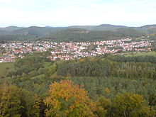
Busenberg lies at 245 m above sea level. NHN in the German part of the Wasgau , the southern part of the Palatinate Forest , in the Dahner Felsenland region , from which the association derives its name. Busenberg includes the hamlet of Bärenbrunnerhof , which is 4 kilometers northeast at the end of the Bärenbrunner Valley and can only be reached via the neighboring village of Schindhard , as well as the Bärenbrunnermühle and Weißensteiner Hof residential areas .
Neighboring communities are - clockwise - Erfweiler , Schwanheim , Oberschlettenbach , Vorderweidenthal - east, 6 kilometers -, Erlenbach (southeast, 5 km), Bundenthal , Bruchweiler-Bärenbach - southwest, 4 kilometers - and Schindhard - north, 1 km -. The closest town is Dahn ; this is located 4 km northwest of Busenberg. The border with the French department Bas-Rhin , alternatively known as "Lower Alsace", runs 8 kilometers to the southwest .
Surveys
The place is surrounded by mountains, which tower over it by about 200 m and whose rock layers consist of fine-grain sandstone. Dominant elevations are the Jüngstberg ( 491 m ) in the southwest and the Löffelsberg ( 445 m ) in the northeast , which is already beyond the boundary of the district . The 447.6 m high Puhlstein is located on the boundary of the Vorderweidenthal and Oberschlettenbach . The 420 m high Heidenkopf rises at the boundary of Erlenbach bei Dahn . The town center stretches in a hollow in between, smaller new development areas have meanwhile grown up on the slopes. In the extreme north of the district on the border to Schwanheim and Erfweiler lies the 476.7 m high Wolfshorn and southwest of it on the border to Erfweiler the Eichelberg .
Waters
The 2.2 km long Geiersteinbach flows west from Busenberg , drains an area of 6 km² and flows from the left into the Lauter , which is called Wieslauter here on the upper reaches . The Kuhbach , which passes the Bärenbrunnermühle and is also a left tributary of the Wieslauter, flows north of the core town in an east-west direction .
history
prehistory
The oldest trace of human settlement since 2018 is a 3.2 cm wide, 2.9 cm long and 0.8 cm thick leaf tip from the late Middle Paleolithic , which belongs to the time about 50,000 to 35,000 years ago. It consists of light gray rock quartzite , has a pointed oval cross-section and is completely retouched on both sides . At the same time, it is the most widely discovered leaf tip so far in the southwest, because leaf tip groups were particularly common in Central, Eastern and Southeastern Europe as far as Turkey, pieces are rarely found as far as England. In the absence of skeletal remains, it is so far unclear whether the carriers of this culture were late Neanderthals or anatomically modern humans.
Medieval village, owned by Dürckheim
The village probably already existed around the year 1200; it was first mentioned in documents in 1408. At an unknown point in time, possibly around 1490, Busenberg came into the possession of the Lords of Dürckheim . The sovereign property of this lower aristocratic family was initially probably organized as part of the Imperial Knighthood and the Upper Rhine District . When France took over sovereignty at the end of the 17th century, the Busenberg rule of Dürckheim, last exercised by Eckebrecht von Türkheim , became a French territory. The Dürckheim initially retained the lower court rights until the last privileges of the nobility were abolished in the wake of the French Revolution .
French rule (1798–1814), Austria and Bavaria (1815/16), Pirmasens (1818)
From 1798 to 1814, when the Palatinate was part of the French Republic (until 1804) and then part of the Napoleonic Empire , Busenberg was incorporated into the canton of Dahn . In 1815 the place Austria was added. Just one year later, Busenberg moved to the Kingdom of Bavaria . From 1818 the place was part of the Landkommissariat Pirmasens , which was converted into a district office in 1862.
French occupation after 1945, Rhineland-Palatinate, territorial reform (1972)
In 1928 the community had 821 residents who lived in 136 residential buildings. In 1939 it was incorporated into the Pirmasens district (from 1997 Südwestpfalz district ) . After the Second World War , the municipality within the French occupation zone became part of the then newly formed state of Rhineland-Palatinate. As part of the first Rhineland-Palatinate administrative reform , Busenberg was assigned to the newly created community of Dahner Felsenland in 1972 .
population
Population development
The population of Busenberg developed as follows, the values from 1871 to 1987 are based on censuses:
|
|
religion
- Christianity
At the end of 2012, 75.3 percent of the population were Catholic and 11.0 percent were Protestant. The rest belonged to another religion or were non-denominational. The Catholics belong to the diocese of Speyer and are subordinate to the deanery of Pirmasens , the Evangelicals to the Protestant regional church of the Palatinate . There is a Catholic church on site. This is called St. Jakobus and contains an organ made by Hugo Mayer Orgelbau from 1971.
- Judaism
The local Jewish community once owned a synagogue that no longer exists. In 1824, when the congregation reached its largest number of members, 127 citizens of the Jewish faith lived in Busenberg . There are no longer any Jewish residents on site. The last of them were deported by the National Socialists in 1940 and are either dead or missing. On November 21, 2007, the Cologne artist Gunter Demnig laid stumbling blocks in front of their previous homes , while the Palatinate dialect poet Albert H. Keil presented his own texts under the title “Culture against right-wing violence”.
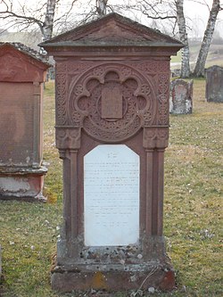
The listed Jewish cemetery has survived in the area around Busenberg . It was desecrated several times in the period after National Socialism and in some cases completely devastated.
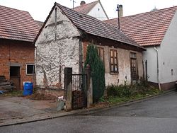
The former ritual Judenbad in Talstrasse was the only Mikweg building in the Palatinate that had been preserved. In 2017 it was demolished because the structural condition was poor and it was not a listed building .
politics
Municipal council
The municipal council in Busenberg consists of 16 council members, who were elected in a personalized proportional representation in the local elections on May 26, 2019 , and the honorary local mayor as chairman.
The distribution of seats in the municipal council:
| choice | SPD | CDU | FWG | total |
|---|---|---|---|---|
| 2019 | 4th | - | 12 | 16 seats |
| 2014 | 3 | - | 13 | 16 seats |
| 2009 | 3 | 3 | 10 | 16 seats |
| 2004 | - | 5 | 11 | 16 seats |
- FWG = Free Voting Community Busenberg e. V.
mayor
Christof Müller (FWG) became the local mayor of Busenberg on June 30, 2016. In the direct election on May 26, 2019, he was confirmed in office for another five years with a share of the vote of 76.91%. Müller's predecessor Klaus Klonig (FWG) resigned in March 2016.
coat of arms
|
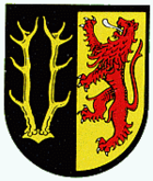
Blazon : "Split by black and gold, on the right a ten-pointed golden deer antler, on the left a blue-armored and tongued red lion."
It was approved by the Neustadt district government in 1972 . |
|
| Justification of the coat of arms: The Palatinate lion stands for the former local lords, the Wittelsbach dukes of Pfalz-Zweibrücken , and the deer antlers come from the coat of arms of the nobles von Drachenfels, who were initially ministerials and feudal men of the Bishop of Speyer . |
Culture and sights
Buildings
The Drachenfels Castle and the Jewish cemetery are a monument zones reported. The former is located just south of Busenberg at an altitude of 368 m with the conspicuous molar , as the rest of the keep is popularly called. It was destroyed in 1523 because part of the inheritance had belonged to the defeated and killed knight Franz von Sickingen . The last lords of the ruin were the lords of Dürkheim , who were expropriated after the French Revolution. Since then, the facility has been owned by the municipality. It was misused as a quarry for several centuries.
The Jewish cemetery with 286 graves is located on a small hill about 500 m southeast of the village in the direction of Bad Bergzabern . It was in use from 1824 until the Nazi era and, for three burials, between 1958 and 1979. Not only in 1938, but long after the end of the Third Reich - 1978, 1994 and 1997 - it was the target of desecration of cemeteries. In 1985 the complex was classified as a protected cultural asset under the Hague Convention .
There are also a total of eleven individual monuments, including the following objects:
Catholic Church - According to a document dated October 6, 1490, the Catholic parish church of St. James emerged from a medieval chapel. It was enlarged and expanded in the late baroque period between 1760 and 1767, and stones from the Drachenfels were also used.
Schlösschen - Baron Franz Christoph Eckbrecht von Dürkheim built a stately country house in 1778 with stones from the Drachenfels in the middle of Busenberg , which is now called "Schlösschen".
nature
Busenberg is located in the Palatinate Forest Nature Park , which in turn is part of the Palatinate Forest-Vosges du Nord Biosphere Reserve . There are a total of five natural monuments on the parish of the local community ; all five objects are rock formations like the Buchkammerfels . The community is also part of the Palatinate Forest climbing area .
folklore
According to a legend, there was once a silver skittles game at Drachenfels Castle
Economy and Infrastructure
economy
Due to the geographical conditions, forest and timber industries have dominated Busenberg for centuries. In the past, the profession of wooden shoemaker was widespread in the village . The community has no industry and is purely residential
traffic
The federal highway 427 runs through Busenberg and runs from northwest to southeast and connects Hinterweidenthal and Kandel for over 44.8 kilometers . In Hinterweidenthal the B 427 is connected to the B 10 , in Bad Bergzabern there is a connection to the federal roads 38 and 48 . In addition, the place is on Deutsche Schuhstrasse . The Bärenbrunnerhof is connected to the road network via Kreisstraße 41 , which leads via Schindhard to the Reichenbach district of the city of Dahn.
The local community is connected to the local transport network via bus line 545 of the Rhein-Neckar transport association , which leads to Bad Bergzabern and Dahn.
In 1911, the Busenberg-Schindhard station was built on the Wieslauterbahn . Although located in the Dahn district at the level of its Reichenbach district, it was designed as a common train station for Busenberg, Erfweiler and Schindhard. In 1966 and 1976, respectively, passenger traffic was discontinued, and in 1997 excursion traffic was reactivated.
The Wieslauterbahn currently runs in the summer months (May to October) on Wednesdays, Saturdays, Sundays and public holidays as well as every year on Shrove Sunday for the carnival parade and the Martini market in Dahn.
tourism
In the last quarter of the 20th century, Busenberg opened up increasingly to tourism . The advertising primarily refers to the location in the middle of the Palatinate Forest Nature Park and recommends hiking and cycling tours. The accommodation offered is mainly private guest rooms and holiday apartments .
In addition, the Drachenfelshütte has been a hiking hut since 1968, which is operated by the local section of the Palatinate Forest Association . By Busenberg extend with that of Kaiserslautern until after silence law Bach leading Pfälzerwald path a so-called trail predicate and the labeled with a yellow bar Fernwanderweg Pirmasens-Belfort . There is also a hiking trail marked with a yellow-red bar , which runs from the Wellbachtal over the northern part of the Busenberger district to Rülzheim .
The 24 km long Busenberger Holzschuhpfad is a circular hiking trail and was laid out to commemorate the craft of wooden shoemakers that used to be widespread in Busenberg and leads over seven mountain peaks and ten viewpoints around the town.
Personalities
Sons and daughters of the church
- Irma Reiss (1892–1942), victim of the Holocaust, a stumbling block was dedicated to her in Munich .
People who worked on site
- Franz Vogel (1850–1926), Catholic priest, was a chaplain on site at times.
- Paul Keller , winner of the Federal Cross of Merit, lives in Busenberg.
- Robert Breitsch , holder of the Order of Merit of the State of Rhineland-Palatinate since 2004 , lives on site
literature
- Otmar Weber: "Like a white lily in its first blossom ..." The Jewish cemetery in Busenberg. Verlag Geiger-Druck, Dahn 1998, ISBN 3-00-003507-9 .
Web links
- Tourist office of the municipality of Busenberg
- Busenberg on the website of the Dahner Felsenland community
- Literature about Busenberg in the Rhineland-Palatinate State Bibliography
Individual evidence
- ↑ State Statistical Office of Rhineland-Palatinate - population status 2019, districts, communities, association communities ( help on this ).
- ↑ Map service of the landscape information system of the Rhineland-Palatinate nature conservation administration (LANIS map) ( notes )
- ↑ State Statistical Office Rhineland-Palatinate (ed.): Official directory of the municipalities and parts of the municipality. Status: January 2018 [ Version 2020 is available. ] . S. 108 (PDF; 2.2 MB).
- ^ S. Gütermann: Blattspitze - first find far in the west . In: Archeology in Germany . January 2019, p. 60 f .
- ↑ daten.digitale-sammlungen.de: List of localities for the Free State of Bavaria . Retrieved July 18, 2018 .
- ↑ a b c busenberg.de: Ortschronik . ( Memento of the original from February 5, 2016 in the Internet Archive ) Info: The archive link was inserted automatically and has not yet been checked. Please check the original and archive link according to the instructions and then remove this notice.
- ↑ Historical map of the Palatinate in 1789. www.hoeckmann.de, accessed on September 6, 2017 .
- ↑ State Statistical Office of Rhineland-Palatinate. Regional data. Retrieved April 13, 2020 .
- ↑ KommWis. As of December 31, 2012. Accessed April 13, 2020 .
- ↑ a b Otmar Weber: 'Like a white lily in its first blossom ... 1998, p. 96 .
- ↑ stolpersteine.eu: Chronicle . Retrieved April 13, 2020 .
- ↑ Albert H. Keil: appearances "Culture against right-wing violence". Verlag PfalzMundArt, accessed on February 5, 2016 .
- ↑ Busenberg (VG Dahner Felsenland, district of Südwestpfalz) Jewish cemetery. alemannia-judaica.de, accessed on February 5, 2016 .
- ↑ ne / tre (author's abbreviation): Last mikveh house demolished . In: The Rheinpfalz , Südwestdeutsche Zeitung . No. 246 . Ludwigshafen October 23, 2017, p. 10 .
- ^ The Regional Returning Officer Rhineland-Palatinate: Local elections 2019, city and municipal council elections.
- ^ Local mayor: Christof Müller clearly elected. Die Rheinpfalz, June 28, 2016, accessed on April 7, 2020 .
- ^ The Regional Returning Officer of Rhineland-Palatinate: direct elections 2019. see Dahner Felsenland, Verbandsgemeinde, second line of results. Retrieved April 7, 2020 .
- ^ Karl Heinz Debus: The great book of arms of the Palatinate. Neustadt an der Weinstrasse 1988, ISBN 3-9801574-2-3 .
- ↑ dahner-felsenland.net: Busenberer Holzschuhpfad ( Memento from August 24, 2009 in the Internet Archive ) (PDF; 4.83 MB).


