Heidenberg (Wasgauer Felsenland)
| Heidenberg | ||
|---|---|---|
|
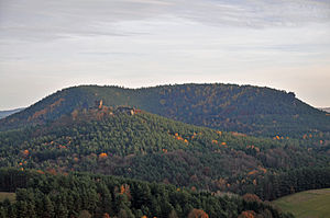
View from Sprinzel (Dickenberg pillar): In the foreground the Drachenfels ruins, behind it the northwest flank of the Heidenberg; The Buchkammerfels can be seen on the right edge of the picture. |
||
| height | 420 m above sea level NHN | |
| location | Rhineland-Palatinate , Germany | |
| Coordinates | 49 ° 6 '57 " N , 7 ° 50' 7" E | |
|
|
||
| particularities | Notoriety through football | |
The Heidenberg is a 420 meter high mountain in the southeastern Wasgau , as the southern part of the Palatinate Forest is also called together with the northern part of the Vosges . The north flank is on the district of Busenberg , the south flank on that of Erlenbach bei Dahn .
Is at its west slope with the book Rock chamber a striking rock formation, a putative Burg point is in the in a direction perpendicular sloping mountain nose consisting of inaccessible rock chambers ( book chambers o. Heide chambers called). The rock chambers are first documented in 1635, where they are described as prisons. This function is just as questionable as the thesis that they would have served the residents of Drachenfels Castle as an additional observation post.
Individual evidence
- ↑ Map services of the Federal Agency for Nature Conservation ( information )
- ^ A b Jürgen Keddigkeit : Heidenberg . In: Jürgen Keddigkeit, Alexander Thon, Rolf Übel (eds.): Palatinate Burgenlexikon. Vol. 2. F - H (= contributions to the history of the Palatinate ). tape 12.2 , 2002, ISBN 3-927754-48-X , ISSN 0936-7640 , p. 313-316 .


