
Althornbach
| coat of arms | Germany map | |
|---|---|---|

|
Coordinates: 49 ° 12 ' N , 7 ° 23' E |
|
| Basic data | ||
| State : | Rhineland-Palatinate | |
| County : | Southwest Palatinate | |
| Association municipality : | Zweibrücken-Land | |
| Height : | 250 m above sea level NHN | |
| Area : | 5.59 km 2 | |
| Residents: | 666 (Dec. 31, 2019) | |
| Population density : | 119 inhabitants per km 2 | |
| Postal code : | 66484 | |
| Area code : | 06338 | |
| License plate : | PS , ZW | |
| Community key : | 07 3 40 201 | |
| LOCODE : | DE 3AL | |
| Association administration address: | Landauer Strasse 18-20 66482 Zweibrücken |
|
| Website : | ||
| Local Mayor : | Bernd Kipp | |
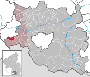
| Location of the local community Althornbach in the district of Südwestpfalz | ||
  |
||


Althornbach is a municipality in the Südwestpfalz district in Rhineland-Palatinate . It belongs to the community of Zweibrücken-Land .
geography
Althornbach is located in the Palatinate region , on the edge of the Zweibrücker hill country in the valley of the Hornbach , mainly to the right of the creek, to which the Althornbach flows through the town from the right . Althornbach also includes the Bödingerhof hamlet and the Buchholzbergerhof and Hübelhof residential areas .
Neighboring communities are - clockwise - Zweibrücken , Contwig , Mauschbach , Hornbach and Blieskastel .
history
Althornbach was first mentioned in 1272 as veteri Horbaco , the Bödingerhof in 1331 as Bedingheim . The places always followed Zweibrücken in terms of their territorial affiliation . Bödingen sank down to a courtyard in the 16th century, then lay deserted until 1670 and was later repopulated.
The village of Althornbach belonged to the Zweibrücken Oberamt Zweibrücken until the end of the 18th century and was the seat of a mayor's shop , to which in 1778 six villages with 207 families belonged.
In 1794 the left bank of the Rhine was occupied in the First Coalition War. From 1798 to 1814 Althornbach belonged to the canton of Neuhornbach in the Donnersberg department . In 1802 173 people lived in the village, including 161 Reformed , three Lutherans , five Mennonites and four Catholics .
Due to the agreements made at the Congress of Vienna , the area first came to Austria in June 1815 and was ceded to the Kingdom of Bavaria in 1816 on the basis of a state treaty . Under the Bavarian administration, Althornbach belonged to the Zweibrücken regional commissioner in the Rhine district from 1817, to the Zweibrücken district office from 1862 and to the Zweibrücken district from 1939 .
After the Second World War , the municipality of Althornbach within the French occupation zone became part of the Palatinate administrative district in the then newly formed state of Rhineland-Palatinate . After the district of Zweibrücken was dissolved (1972), Althornbach was incorporated into the district of Pirmasens (renamed in 1997 to the district of Südwestpfalz ).
- Population development
The development of the population of Althornbach, the values from 1871 to 1987 are based on censuses:
|
|
politics
Municipal council
The local council in Althornbach consists of twelve council members, who were elected in a personalized proportional representation in the local elections on May 26, 2019 , and the honorary local mayor as chairman.
The distribution of seats in the municipal council:
| choice | SPD | FDP | UWG | BL | total |
|---|---|---|---|---|---|
| 2019 | 5 | - | 7th | - | 12 seats |
| 2014 | 8th | - | 4th | - | 12 seats |
| 2009 | 7th | - | 1 | 4th | 12 seats |
| 2004 | 7th | 3 | 2 | - | 12 seats |
- UWG = Independent Voting Association Zweibrücken-Land e. V.
mayor
Bernd Kipp (UWG) became the local mayor of Althornbach on August 18, 2019. In the direct election on May 26, 2019, he was elected for five years with a share of the vote of 75.81%. Kipp's predecessor Ute Klein (SPD) did not run again after more than 20 years in office.
coat of arms
|
|
Blazon : "In gold on green ground next to each other on the right a green deciduous tree, on the left a red lion."
It was awarded in 1968 by the Rheinhessen-Pfalz district government . |
Economy and Infrastructure
traffic
Althornbach is on the B 424 . It is 5 km to the A 8 . The former Hornbachbahn has been closed, and a bike path runs along the route.
For Zweibrücken is 10 km away and Saarbrücken Airport 38 kilometers by car.
Sons and daughters of the church
- Willi Schmidt (* 1934), honorary mayor of Althornbach (1973–1997), member of the Rhineland-Palatinate state parliament (1979–1996 / SPD); Honorary citizen of Althornbach since 1997, author: "Dare to dare more justice" (2011)
- Hans Beckmann (* 1959), politician (SPD)
See also
Web links
- Literature about Althornbach in the Rhineland-Palatinate state bibliography
- Local community Althornbach on the website of the Zweibrücken-Land association
- Private homepage about Althornbach
Individual evidence
- ↑ a b State Statistical Office of Rhineland-Palatinate - population status 2019, districts, municipalities, association communities ( help on this ).
- ↑ State Statistical Office Rhineland-Palatinate (ed.): Official directory of the municipalities and parts of the municipality. Status: January 2018 [ Version 2020 is available. ] . S. 110 (PDF; 2.2 MB).
- ↑ a b Michael Frey : Attempt at a geographical-historical-statistical description of the king. bayer. Rheinkreises , Volume 4, F. C. Neidhard, 1837, p. 135 ( Google Books )
- ↑ Official municipality directory (= State Statistical Office of Rhineland-Palatinate [Hrsg.]: Statistical volumes . Volume 407 ). Bad Ems February 2016, p. 155 (PDF; 2.8 MB).
- ↑ State Statistical Office Rhineland-Palatinate - regional data
- ^ The Regional Returning Officer Rhineland-Palatinate: Municipal elections 2014, city and municipal council elections
- ↑ Norbert Schwarz: Local board entirely in UWG hand. Pfälzischer Merkur, August 18, 2019, accessed on March 22, 2020 .
- ^ The State Returning Officer Rhineland-Palatinate: direct elections 2019. see Zweibrücken-Land, Verbandsgemeinde, first line of results. Retrieved March 22, 2020 .
- ^ Norbert Schwarz: Ute Klein's last New Years reception. Pfälzischer Merkur, January 2, 2019, accessed on March 22, 2020 .

Cities: Dahn | Hornbach | Rodalben
Municipalities: Althornbach | Battweiler | Bechhofen | Biedershausen | Bobenthal | Bottenbach | Bruchweiler-Bärenbach | Bundenthal | Busenberg | Clausen | Contwig | Darstein | Dellfeld | Dietrichingen | Dimbach | Donsieders | Eppenbrunn | Erfweiler | Erlenbach near Dahn | Fischbach near Dahn | Geiselberg | Großbundenbach | Grosssteinhausen | Hauenstein | Heltersberg | Hermersberg | Herschberg | Hettenhausen | Hilst | Hinterweidenthal | Hirschthal | Höheinöd | Höheischweiler | Cave frogs | Horbach | Käshofen | Kleinbundenbach | Kleinsteinhausen | Knopp-Labach | Crows Mountain | Kröppen | Gluing | Lviv | Ludwigswinkel | Lug | Maßweiler | Mauschbach | Merzalben | Münchweiler an der Rodalb | Niederschlettenbach | Nothweiler | Nünschweiler | Obernheim-Kirchenarnbach | Upper sime | Petersberg | Reifenberg | Riedelberg | Rieschweiler-Mühlbach | Rose head | Rumbach | Ruppertsweiler | Saalstadt | Schauerberg | Schindhard | Schmalenberg | Schmitshausen | Schönau | Schwanheim | Schweix | Spirkelbach | Stone albums | Thaleischweiler frogs | Trulben | Vinningen | Waldfischbach castle albums | Wallhalben | Walshausen | Weselberg | Wiesbach | Wilgartswiesen | Winterbach