
Ludwigswinkel
| coat of arms | Germany map | |
|---|---|---|

|
Coordinates: 49 ° 5 ' N , 7 ° 40' E |
|
| Basic data | ||
| State : | Rhineland-Palatinate | |
| County : | Southwest Palatinate | |
| Association municipality : | Dahn rock country | |
| Height : | 240 m above sea level NHN | |
| Area : | 21.28 km 2 | |
| Residents: | 767 (Dec. 31, 2019) | |
| Population density : | 36 inhabitants per km 2 | |
| Postal code : | 66996 | |
| Area code : | 06393 | |
| License plate : | PS , ZW | |
| Community key : | 07 3 40 029 | |
| Association administration address: | Schulstrasse 29 66994 Dahn |
|
| Website : | ||
| Local Mayor : | Sebald Liesenfeld | |
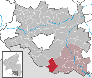
| Location of the local community Ludwigswinkel in the district of Südwestpfalz | ||
  |
||


Ludwigswinkel is a municipality in the district of Südwestpfalz in Rhineland-Palatinate . It belongs to the community of Dahner Felsenland , which has its administrative seat in the city of Dahn . Ludwigswinkel is one of the younger villages in the southwest Palatinate and borders on France.
geography
location
Ludwigswinkel is located in Wasgau , as the southern part of the Palatinate Forest and the adjoining northern part of the Vosges are also called, directly on the border with France . Most of the area belongs to the Dahner Felsenland , only the west is part of the south-western Palatinate Forest , alternatively called Bitscher Waldniederung . 86.7 percent of the district area is forested. To the northeast is Fischbach bei Dahn , to the east is Petersbächel and to the southwest within Lorraine Sturzelbronn . The next larger city is Pirmasens in the northwest. In the north of the village, the Schöntal district is somewhat isolated , the other part of the village has no middle name. Ludwigswinkel also includes the Reisslerhof and Sägemühle Saarbacherhammer residential areas . On site, the Woog valleys shape the landscape. Neighboring communities are - clockwise - Lemberg , Fischbach bei Dahn, Obersteinbach , Sturzelbronn and Eppenbrunn .
Surveys
In the north-west of the district rise the ( 440.4 m above sea level ) high Große Biesenberg , 451 m above sea level. NHN meter high Kleine Biesenberg , the ( 435 m above sea level ) meter high Goldgrübel and the Horbachkanzel . Immediately south of the settlement area the high Schwarzbuckel ( 262 m above sea level ) and southwest of this the Huckenbühl and the Blaufels . At the border with France are the ( 399.1 m above sea level ) meter high Adelsberg and the ( 382 m above sea level ) high Rösselsberg .
Waters
There are several bodies of water around the village. The Sauer , which receives several tributaries in the area of the municipality, runs north of the settlement area. From the right at the level of the Schöntal pond , the stream flows from the Reisslerhof . Further east comes the Große Horbach from the left and the Rösselsbach from the right . Not far from the district boundary to Fischbach, the Dielbach flows from the left . The stony brook in the west forms the border to Eppenbrunn. On the northeastern edge of the settlement there is also the Klößweiher and on the southern edge of the Sägmühlweiher . Further to the east are the Saarbacherhammer and the Mühlweiher .
history
The place was in 1783 by Landgrave Ludwig IX. founded by Hessen-Darmstadt as a place for soldiers to relax. Ludwigswinkel belonged to the Lemberg office and was part of the Obersteinbach official school building . In the course of the French Revolution , which in 1792 reached the region called Hackmesserseite and thus Ludwigswinkel as well, all areas on the left bank of the Rhine - and thus also the office of Lemberg and Ludwigswinkel - fell to France in 1794 (until 1804) and were then part of the Napoleonic Empire . Initially, the place was under the canton of Breidenbach . From 1801 Ludwigswinkel was incorporated into the canton of Bitche .
In 1814 the place moved to the canton of Pirmasens . In 1815 the place Austria was added. Just one year later, the community moved to the Kingdom of Bavaria and was part of the Rhine district there . In 1817 the community was reclassified to the canton of Dahn . From 1818 the place was part of the Landkommissariat Pirmasens , which was converted into a district office in 1862.
The Ludwigswinkel camp received its own church at the instigation of the French clergyman Paul Rémond , who at the time was chaplain general of the Rhine Army. In 1927, 16,000 soldiers were stationed in the “Ludwigswinkel Camp”, which to this day reflects the population of the entire Dahn Rock Country.
In 1939 Ludwigswinkel was incorporated into the district of Pirmasens (from 1997 district of Südwestpfalz ) . Since the place was in the Red Zone , the residents were temporarily evacuated with the beginning of World War II . After the war, the municipality within the French occupation zone became part of the then newly formed state of Rhineland-Palatinate. In the course of the first administrative reform in Rhineland-Palatinate , the municipality was assigned to the newly created community of Dahner Felsenland in 1972 .
In 2008 the village became the state winner in the competition Our village has a future . Among other things, it was recognized for exemplary ecological performance.
population
Population development
In 1802 the community had a total of 295 inhabitants.
religion

In 2012, 44.9 percent of the population were Protestant and 36.2 percent Roman Catholic . The rest belonged to another religion or were non-denominational. The Catholics belong to the Diocese of Speyer , the Evangelicals to the Protestant Church of the Palatinate .
politics
Municipal council
The municipal council in Ludwigswinkel consists of twelve council members, who were elected in the local elections on May 26, 2019 in a majority vote, and the honorary local mayor as chairman.
mayor
Sebald Liesenfeld became the local mayor of Ludwigswinkel in 2014. In the direct election on May 26, 2019, he was confirmed in his office for another five years with a share of the vote of 88.14 percent. His predecessors were Gerhard Ecker and Gerhard Andreas.
coat of arms
|
|
Blazon : "In blue on the right a golden angle, inside a red capital letter L, on the left a lion divided seven times by silver and red." |
| Founding of the coat of arms: It was approved by the Neustadt district government in 1968 and, with the Hessian lion, refers to the founding history of the place. |
Culture and sights
Cultural monuments

The Zollhof and Landgrafenstraße are designated as monument zones. There are also five individual objects that are listed , including the Reisslerhof .
nature
The municipality is located in the Palatinate Forest Nature Park , which in turn belongs to the Palatinate Forest-Vosges du Nord biosphere reserve , which is protected by UNESCO . The Rohrweiher, the Adelsberg and the Mümmelsköpf massif, which is partly within the boundaries of Ludwigswinkel , each form the core areas of the nature park. There are a total of four natural monuments on site . Nature reserves in the town district are the Klößweiher, pipe Weiher-Weiher Roessel , at Saar Bacher Mühlweiher and partially owned already Fischbach Faunertal .
Knight stones

There are a total of four knight stones on the municipality marker . The knight's stone with the number 192 bears the name Roesselsbrunner Hof ruin and refers to a lost courtyard. 197 The Reissler forester's house stood here, marking the site of a forester's house that was destroyed in World War II. 198 Saarbach-Ursprung is located at the source of the Sauer. 201 Faunerhof ruins mark a courtyard that was demolished in 1869 and existed since the twelfth century.
societies
The Gray Corps , which existed from 1930 to 1934, was founded in Ludwigswinkel. In addition, there is a local branch of the Palatinate Forest Association , which operated the Hohe List hiking home, which was already in the Eppenbrunn district, until 2016 .
Economy and Infrastructure
economy
For centuries, forestry was dominant in the municipality due to the geographical conditions; For example, the Reisslerhof once functioned as a forester's house. After the First World War , an infantry regiment and an artillery division of the French armed forces were stationed on site as reparations until 1930 , since the nearby Bitsch military training area alone did not meet their requirements.
Ludwigswinkel has been a state-approved climatic health resort since 2002 . The village has neither agricultural land nor a business park and, apart from a few small craft businesses, is dependent on tourism and gastronomy. Up until 1992 there was an American Forces Network soldier station on site . The Daniel Theysohn Foundation is also located in Ludwigswinkel .
traffic

From 1921 Ludwigswinkel was the terminus of the narrow-gauge Wasgauwaldbahn , which began at Bundenthal-Rumbach station on the Wieslauterbahn and initially served exclusively as an army field railway for the French troops; from 1924 onwards it also had passenger traffic in order to reduce the operating deficit. With Saarbachhammer , Ludwigswinkel Ort and the terminus Ludwigswinkel Lager there were three operating points in the municipality. With the abandonment of the military training area in 1930, the route was deprived of its livelihood, which is why it was closed in the same year. The former locomotive shed at the end of the line was retained.
State road 478 runs north of the settlement area ; it leads from the state border with Saarland near Hornbach to the German-French border near Sankt Germanshof . The state road 487 that branches off from it creates a connection to Hinterweidenthal . The district road 43 connects the place with Petersbächel and Schönau ; District road 47 branches off from here and ends a short time later at the entrance to the village.
tourism
The Hornbach-Fleckenstein-Radweg leads along the northern edge of the settlement from Bundenthal to Hornbach . A hiking trail that is marked with a green bar runs through the village . The Höcherbergweg , marked with a red and white bar , connects to Niederwürzbach and Böchingen and one that is marked with a “green and blue bar” leads through the north of the district . The Wasgau Lakes Tour is a circular route that leads through Fischbach and Ludwigswinkel. In addition, the Felsenland Sagenweg leads through the east of the district. In addition, the community was a station on the West Palatinate hiking trail .
In the leisure park Birkenfeld there is a mini golf course , tennis courts, football fields, a 1.6 km long barefoot path , a playground and a kiosk. Next to the amusement park there is also a 2.5 kilometer long sculpture path with 33 sculptures carved out of wood. There is also a youth camp on site.
Personalities
Honorary citizen

- Daniel Theysohn (1904–1980), entrepreneur
- Ruth Theysohn (1913–1997), first Palatinate wine queen
People who worked on site
- Karl Albrecht von Ritter (1836–1917), Bavarian forest clerk, government director and founding chairman of the Palatinate Forest Association, was a local forester at times
- Sturm Kegel (1892–1979), architect, town planner and construction clerk, worked from 1923 to 1926 at the Reich New Building Office in Ludwigswinkel
- Gerhard Franz (1902–1975), officer, fought on site in World War II from late 1944 onwards
literature
- Friedrich Knöpp: Territorial holdings of the County of Hanau-Lichtenberg in Hesse-Darmstadt . Ed .: Hessisches Staatsarchiv Darmstadt . Darmstadt 1962 (signature: N 282/6).
- Alfred Matt: Bailliages, prévôté et fiefs ayant fait partie de la Seigneurie de Lichtenberg, du Comté de Hanau-Lichtenberg, du Landgraviat de Hesse-Darmstadt . In: Société d'Histoire et d'Archaeologie de Saverne et Environs (ed.): Cinquième centenaire de la création du Comté de Hanau-Lichtenberg 1480 - 1980 = Pays d'Alsace 111/112 (2, 3/1980) . 1980, p. 7-9 .
Web links
- Website of the Ludwigswinkel community
- Literature about Ludwigswinkel in the Rhineland-Palatinate state bibliography
Individual evidence
- ↑ State Statistical Office of Rhineland-Palatinate - population status 2019, districts, communities, association communities ( help on this ).
- ↑ State Statistical Office Rhineland-Palatinate (ed.): Official directory of the municipalities and parts of the municipality. Status: January 2019 [ Version 2020 is available. ] . S. 171 (PDF; 3 MB).
- ↑ Knöpp, p. 10; Matt, p. 9.
- ↑ Directory of officials .
- ↑ local chronicle. In: ludwigswinkel.de. 2012, accessed April 9, 2019 .
- ↑ KommWis, as of December 31, 2012
- ^ The Regional Returning Officer Rhineland-Palatinate: Local elections 2019, city and municipal council elections
- ↑ Church with potential. Two questions - two answers: Sebald Liesenfeld. Die Rheinpfalz, December 7, 2018, accessed on April 8, 2020 .
- ^ The Regional Returning Officer for Rhineland-Palatinate: direct elections 2019. see Dahner Felsenland, Verbandsgemeinde, ninth line of results. Retrieved April 8, 2020 .
- ↑ local chronicle. Local community Ludwigswinkel, accessed on April 8, 2020 .
- ^ Karl Heinz Debus: The great book of arms of the Palatinate. Neustadt an der Weinstrasse 1988, ISBN 3-9801574-2-3 .
- ↑ State Statistical Office Rhineland-Palatinate - regional data

Cities: Dahn | Hornbach | Rodalben
Municipalities: Althornbach | Battweiler | Bechhofen | Biedershausen | Bobenthal | Bottenbach | Bruchweiler-Bärenbach | Bundenthal | Busenberg | Clausen | Contwig | Darstein | Dellfeld | Dietrichingen | Dimbach | Donsieders | Eppenbrunn | Erfweiler | Erlenbach near Dahn | Fischbach near Dahn | Geiselberg | Großbundenbach | Grosssteinhausen | Hauenstein | Heltersberg | Hermersberg | Herschberg | Hettenhausen | Hilst | Hinterweidenthal | Hirschthal | Höheinöd | Höheischweiler | Cave frogs | Horbach | Käshofen | Kleinbundenbach | Kleinsteinhausen | Knopp-Labach | Crows Mountain | Kröppen | Gluing | Lviv | Ludwigswinkel | Lug | Maßweiler | Mauschbach | Merzalben | Münchweiler an der Rodalb | Niederschlettenbach | Nothweiler | Nünschweiler | Obernheim-Kirchenarnbach | Upper sime | Petersberg | Reifenberg | Riedelberg | Rieschweiler-Mühlbach | Rose head | Rumbach | Ruppertsweiler | Saalstadt | Schauerberg | Schindhard | Schmalenberg | Schmitshausen | Schönau | Schwanheim | Schweix | Spirkelbach | Stone albums | Thaleischweiler frogs | Trulben | Vinningen | Waldfischbach castle albums | Wallhalben | Walshausen | Weselberg | Wiesbach | Wilgartswiesen | Winterbach