West Palatinate hiking trail
| Great West Palatinate Hiking Trail (dissolved) | |
|---|---|
 Forest and meadow landscapes characterize the West Palatinate hiking trail |
|
| map | |

|
|
| Data | |
| length | 409 km |
| location | West Palatinate |
| Markers |
|
| Type | Circular hiking trail |
| Level of difficulty | light |
| season | all year round |
| particularities | Alternative routes and cross paths exist (also marked with colored signposts W). |
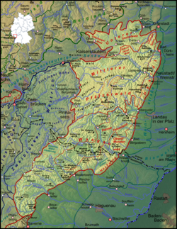
The West Palatinate Hiking Trail (actually: Great West Palatinate Hiking Trail ) was a hiking trail that led across the West Palatinate and is no longer maintained. The package tour concept of the hiking trail launched in 1980 by the Association for the Promotion of Tourism in the West Palatinate included a cooperation between the districts of the West Palatinate, the Palatinate Forest Association and the restaurateurs. In 2006 and 2007 the number of overnight stays fell to such an extent that the sponsoring association has not maintained any booking offers since 2009 and the Palatinate Forest Association only maintains the path markings in sub-areas. The dissolution of the sponsoring association is being considered.
course
The West Palatinate hiking trail began in the Kaiserslautern district of Hohenecken and led via Leimen (Pfalz) , Hauenstein , Rumbach , Ludwigswinkel , Eppenbrunn and back via Landstuhl , Wolfstein , Rockenhausen , Kirchheimbolanden , Eisenberg , Hochspeyer to Hohenecken.
In total, it was 409 kilometers long, making it the longest marked circular hiking system in Germany. The hiking trail had a crossbar between Kaiserslautern and Landstuhl , so that it was divided into a northern and a southern half.
The Great West Palatinate Hiking Trail was one of a total of 12 West Palatinate hiking trails that were created and maintained by the Association for the Promotion of Tourism in the West Palatinate .
The Palatinate Forest Association was responsible for marking the path. The waymarking of the main way was a stylized white or black W , side ways were given different colored markings.
Web links
- www.westpfalz-wanderweg.de ( Memento from February 23, 2008 in the Internet Archive ) Historical status from February 23, 2008, in the Internet Archive . The original website is no longer available, the site is operated by a different operator. (accessed on October 31, 2009)
Individual evidence
- ^ The Rheinpfalz , Südwestdeutsche Zeitung: Has the "W" run out? , April 3, 2009
- ↑ West Palatinate Hiking Trail ( Memento from September 30, 2008 in the Internet Archive ) on wanderportal-pfalz.de
- ↑ ( page no longer available , search in web archives: West Palatinate hiking trail ) on the website of the community of Göllheim