
Wolfstein
| coat of arms | Germany map | |
|---|---|---|

|
Coordinates: 49 ° 35 ' N , 7 ° 36' E |
|
| Basic data | ||
| State : | Rhineland-Palatinate | |
| County : | Kusel | |
| Association municipality : | Lauterecken-Wolfstein | |
| Height : | 189 m above sea level NHN | |
| Area : | 13.74 km 2 | |
| Residents: | 1903 (Dec. 31, 2019) | |
| Population density : | 139 inhabitants per km 2 | |
| Postal code : | 67752 | |
| Area code : | 06304 | |
| License plate : | KUS | |
| Community key : | 07 3 36 105 | |
| Association administration address: | Schulstrasse 6a 67742 Lauterecken |
|
| Website : | ||
| City Mayor : | Herwart Dilly | |
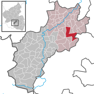
| Location of the city of Wolfstein in the Kusel district | ||
  |
||


Wolfstein is a town in the Kusel district in Rhineland-Palatinate . It belongs to the Verbandsgemeinde Lauterecken-Wolfstein , within which it is the second largest local community in terms of inhabitants. It is also the seventh largest in terms of population within the district and the smallest that has city rights. Wolfstein is a state-approved resort and designated as a basic center according to state planning . In terms of population, Wolfstein is also one of the smallest cities in Germany.
geography
location
Wolfstein is located in the north-western part of the Palatinate in the North Palatinate Bergland (so-called "King's Land") between Idar-Oberstein and Kaiserslautern in the north-east of the Kusel district. The minerals analcime , grossular and prehnite occur locally . The urban area covers 13.74 km². Neighboring communities are - clockwise - Heinzenhausen , Hohenöllen , Oberweiler-Tiefenbach , Einöllen , Relsberg , Niederkirchen , Kreimbach-Kaulbach , Rutsweiler an der Lauter , Essweiler , Aschbach , Offenbach-Hundheim and Lohnweiler .
City structure
Wolfstein is divided into the two districts Wolfstein with the districts Pfingstweide, Reckweilerhof and Schwanenhof and Roßbach with the districts Immetshausen , Mühle and Stahlhausen.
Elevations and waters
The Lauter flows through the city in a south-north direction; the Selbach flows into it from the left and the Roßbach and the Breitbach from the right . Pronounced mountains are the Königsberg ( 568 m above sea level ) in the southwest and the Eisenknopf ( 308.5 m above sea level ) in the north of the city.
climate
The annual precipitation is 729 mm. The precipitation is in the middle third of the values recorded in Germany. Lower values are registered at 46% of the German Weather Service's measuring stations . The driest month is April, with the most rainfall in June. In June there is 1.4 times more rainfall than in April. Precipitation varies only minimally and is extremely evenly distributed over the year. Lower seasonal fluctuations are recorded at just one percent of the measuring stations .
history
Wolfstein was founded in 1275 on the instructions of Rudolf I von Habsburg and immediately received city rights . Wolfstein went to the Count Palatinate (later Electoral Palatinate ) in 1357 under Emperor Charles IV . During this time, the city belonged to Palatinate-Lautern , which formed an independent territory within the Holy Roman Empire from 1559 to 1592 . Afterwards, Wolfstein was the seat of an Electoral Palatinate sub-office that belonged to the Lautern Upper Office until the end of the 18th century .
After 1792 French revolutionary troops occupied the region and annexed it after the Peace of Campo Formio (1797) . From 1798 to 1804 Wolfstein belonged to the First French Republic and then to the Napoleonic Empire . The city was part of the Donnersberg department and was the main town ( chef-lieu ) of the canton of the same name .
Due to the agreements made at the Congress of Vienna in 1815 and an exchange treaty with Austria , the region became part of the Kingdom of Bavaria in 1816 . From 1818 Wolfstein was assigned to the Kusel Land Commissioner in the Bavarian Rhine District before it was converted into a district office in 1862 . In the 19th century Wolfstein also developed into one of the centers of the West Palatinate touring musicians ; more than 200 musicians of this traveling trade came from the city. After the Palatinate uprising in 1848/49, many citizens emigrated to America. The Protestant church was built in 1866.
In 1915, in the middle of the First World War , Wolfstein acted as a local collection point for gifts of love for the immediate surrounding communities .
In 1939 the city was incorporated into the Kusel district. After the Second World War , Rechtenbach became part of the then newly formed state of Rhineland-Palatinate within the French occupation zone . In the course of the first administrative reform in Rhineland-Palatinate , the previously independent municipality of Roßbach was incorporated on June 7, 1969. Since 1971, the city has been the administrative seat of the Verbandsgemeinde of the same name , which merged with the Verbandsgemeinde Lauterecken in 2014 to form the new Verbandsgemeinde Lauterecken-Wolfstein based in Lauterecken.
Population development
Development of the population of Wolfstein in relation to today's urban area; the values from 1871 to 1987 are based on censuses:

|
|
politics
City council
The city council in Wolfstein consists of 16 council members, who were elected in the local elections on May 26, 2019 in a personalized proportional representation, and the honorary city mayor as chairman.
The distribution of seats in the city council:
| choice | SPD | CDU | FDP | FWG | total |
|---|---|---|---|---|---|
| 2019 | 5 | 4th | 1 | 6th | 16 seats |
| 2014 | 4th | 5 | 2 | 5 | 16 seats |
| 2009 | 4th | 3 | 3 | 6th | 16 seats |
| 2004 | 4th | 5 | 2 | 5 | 16 seats |
- FWG = Association for the promotion of local politics in the area of the Verbandsgemeinde Wolfstein e. V.
mayor
Herwart Dilly became mayor of Wolfstein in 2009. In the direct election on May 26, 2019, he was confirmed in office for a further five years with a share of the vote of 74.57%.
Gerhard Kirch (FWG), as Dilly's predecessor, held the office from 1984 to 2009.
Town twinning
Wolfstein has been twinned with Verdun-sur-le-Doubs in Burgundy (France) since 2000 .
coat of arms
|
|
|
| Justification of the coat of arms: The wolf and the three stones make it a so-called "speaking coat of arms". |
Buildings

The city center, the ruins of the castles Alt-Wolfstein , which was the nucleus of the city, and Neu-Wolfstein , the lime mine on Königsberg and the war memorial in the Roßbach district are designated as monument zones. In addition, there are a total of 14 individual objects that are listed .
Economy and Infrastructure
economy
The historical lime mine in Wolfstein is a testament to the industrial past. An expert guide takes the visitor into the lime mine on Königsberg , where limestone was broken underground until 1967 and processed on site. All facilities are available in the original. The lime mine on Königsberg is considered an industrial monument of special standing and is unique in Germany. In addition to the lime mine on Königsberg, there were numerous other pits on site . In the meantime, mining has come to a standstill. The most important employer and with a long history associated with Wolfstein is Karl Otto Braun GmbH & Co. KG , which has been part of the Hartmann Group since 2010 . The Sander family of instrument makers used to have a workshop in the city. Volksbank Lauterecken also has a branch in Wolfstein. The Kreissparkasse Wolfstein was in 1959 in the Kreissparkasse Kusel .
traffic


Wolfstein is also on the Lautertalbahn . There are three rail transport stops in the city, the most important being Wolfstein station with the highest number of passengers on the route. In the course of its emergence, conflicts arose because it was on the boundary of the then independent community of Roßbach; the disputes continued until 1906, when the Lautertal Railway had been in operation for more than 20 years. The station has had no freight traffic since 2000; at that time it was the last tariff point for goods along the railway line. In 2005, the platforms were made accessible to the disabled. In addition, the districts of Roßbach and Reckweilerhof each have rail transport stops. The iron button tunnel, the only tunnel on the railway line, is also located within the city limits . In 2000, the city became part of the newly founded West Palatinate Transport Association (WVV) before it was merged into the Rhein-Neckar Transport Association (VRN) in 2006, to which Wolfstein has belonged ever since.
The federal highway 270 runs through Wolfstein . The bypass road of the B 270 was opened to traffic on November 17, 2006 after almost five years of construction. District road 48 also runs through the Roßbach district . The city itself is connected to the local transport network via the bus routes 274 and 275 of the Rhein-Neckar transport association, both of which connect them to the district town of Kusel . The approximately 100-kilometer Palatinate High Trail has been leading from Winnweiler via Rockenhausen to Wolfstein since 2011 . In addition, the city was a station on the West Palatinate hiking trail .
Institutions
While it was part of France, the city was the seat of a peace court that was subordinate to the Tribunal of First Instance in Kaiserslautern . Since the buildings of the Kaiserslautern Regional Court fell victim to a bomb attack in 1944, it temporarily relocated its headquarters to Wolfstein until a new building was completed in Kaiserslautern. Until 1966, Wolfstein was also the seat of a local court .
There is also a regional school and a local and printing museum on site. From 1971 to 2014 Wolfstein was the seat of the community of the same name, since then the city has housed a second administrative office of the Lauterecken-Wolfstein community . There is also a youth hostel, which was built between 1978 and 1980, and a senior citizens' center.
Personalities
Honorary citizen
- Heinrich Rheinheimer, senior teacher
- Hans Braun, manufacturer
- Karl Hönes, City Mayor
- Franz Braun, manufacturer
- Kurt Dreger, City Mayor
- Pauline König (1868–1938), local poet
- Gerhard Kirch, mayor from 1984 to 2019
- Ernst Vogt
sons and daughters of the town
- Friedrich Jakob Sander (* 1809, † 1876 in Kaiserslautern), instrument maker
- Franz Schmitt (1816–1891), painter
- Ernst Krieger (1867–1943), chess composer
- Alfred Lehmann (1867–1919), member of the Bavarian state parliament and winegrower
- Pauline König (1868–1938), local poet
- Karl Groß (1883–1949), politician (FDP)
- Fritz Zolnhofer (1896–1965), painter
- Friedrich Jossé (1897–1994), painter and graphic artist
- Erich Koch (1924–2014), sculptor
- Ernst-Rainer Hönes (* 1942), monument conservator and lawyer
People who have worked in the city
- Heinrich II. Von Sponheim-Starkenburg (1292 / 95–1323), nobleman, died in Wolfstein.
- Loretta von Sponheim (1300–1346), Countess, had her residence in Wolfstein from 1323 on.
- Georg Philipp Schmitt (1808–1873), grew up in Wolfstein.
- Hippolyt August Schaufert (1834–1872), worked for a time at the Wolfstein notary's office.
- Philipp Hammer (1837–1901), priest, was pastor in Wolfstein from 1865.
- Rudolf Sander (1866–1942), instrument maker, died in Wolfstein.
literature
- Literature about Wolfstein in the Rhineland-Palatinate State Bibliography
Web links
- Internet presence of the city of Wolfstein
- Local community Wolfstein on the website of the Verbandsgemeinde Lauterecken-Wolfstein
- Wolfstein at regionalgeschichte.net
Individual evidence
- ↑ State Statistical Office of Rhineland-Palatinate - population status 2019, districts, communities, association communities ( help on this ).
- ↑ a b State Statistical Office Rhineland-Palatinate - regional data
- ↑ State Statistical Office Rhineland-Palatinate (ed.): Official directory of the municipalities and parts of the municipality. Status: January 2019 [ Version 2020 is available. ] . S. 155 (PDF; 3 MB).
- ↑ Official municipality directory (= State Statistical Office of Rhineland-Palatinate [Hrsg.]: Statistical volumes . Volume 407 ). Bad Ems February 2016, p. 183 (PDF; 2.8 MB).
- ^ The Regional Returning Officer Rhineland-Palatinate: Local elections 2019, city and municipal council elections
- ^ The State Returning Officer Rhineland-Palatinate: direct elections 2019. see Lauterecken-Wolfstein, Verbandsgemeinde, last line of results. Retrieved May 3, 2020 .
- ↑ Friends from Wolfstein have two castles. Neumarkter Nachrichten, May 13, 2017, accessed on May 3, 2020 .
- ↑ Eric Sayer: Certificates for two veterans. Die Rheinpfalz, January 29, 2019, accessed on May 3, 2020 .

Adenbach | Albessen | Altenglan | Altenkirchen | Aschbach | Bedesbach | Blaubach | Börsborn | Bosenbach | Breitenbach | Bridges (Palatinate) | Buborn | Cronenberg | Deimberg | Dennweiler-Frohnbach | Dittweiler | Dunzweiler | Ehweiler | Oiling | Elzweiler | Erdesbach | Eßweiler | Etschberg | Föckelberg | Frohnhofen | Ginsweiler | Glan-Münchweiler | Glan bridges | Semolina | Grumbach | Haschbach am Remigiusberg | Hausweiler | Hefersweiler | Heinzenhausen | Henschtal | Herchweiler | Herren-Sulzbach | Herschweiler-Pettersheim | Hinzweiler | Hohenöllen | Homberg | Hoppstädten | Horschbach | Hüffler | Jettenbach | Kappeln | Kirrweiler | Konken | Körborn | Kreimbach-Kaulbach | Krottelbach | Kusel | Langenbach | Boring | Lauterecken | Lohnweiler | Matzenbach | Medard | Merzweiler | Nanzdietschweiler | Nerzweiler | Neunkirchen am Potzberg | Lower albums | Niederstaufenbach | Nussbach | Top albums | Oberstaufenbach | Oberweiler im Tal | Oberweiler-Tiefenbach | Odenbach | Offenbach-Hundheim | Ohmbach | Pfeffelbach | Quirnbach / Palatinate | Rammelsbach | Rathsweiler | Rehweiler | Reichweiler | Reipoltskirchen | Relsberg | Rothselberg | Ruthweiler | Rutsweiler am Glan | Rutsweiler an der Lauter | Saint Julian | Schellweiler | Schönenberg-Kübelberg | Selchenbach | Steinbach am Glan | Thallichtenberg | Theisbergstegen | Ulmet | Unterjeckenbach | Delusional | Forest black | Welchweiler | Wiesweiler | Wolfstein