Theisbergstegen
| coat of arms | Germany map | |
|---|---|---|

|
Coordinates: 49 ° 31 ' N , 7 ° 27' E |
|
| Basic data | ||
| State : | Rhineland-Palatinate | |
| County : | Kusel | |
| Association municipality : | Kusel-Altenglan | |
| Height : | 244 m above sea level NHN | |
| Area : | 5 km 2 | |
| Residents: | 700 (Dec. 31, 2019) | |
| Population density : | 140 inhabitants per km 2 | |
| Postal code : | 66871 | |
| Area code : | 06381 | |
| License plate : | KUS | |
| Community key : | 07 3 36 098 | |
| LOCODE : | DE TIB | |
| Association administration address: | Marktplatz 1 66869 Kusel |
|
| Website : | ||
| Local Mayor : | Stefan Klein | |
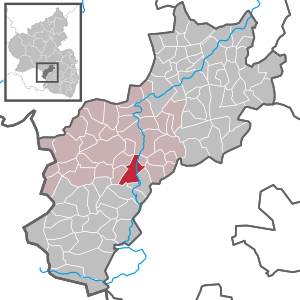
| Location of the local community Theisbergstegen in the Kusel district | ||
Theisbergstegen is a municipality in the Kusel district in Rhineland-Palatinate . It belongs to the Kusel-Altenglan community and lies on both sides of the Glan .
geography
location
The community is located in the so-called Musikantenland , a part of the North Palatinate Bergland . In the south of the municipality there is also the district of Godelhausen . Neighboring communities are - clockwise - Altenglan , Rutsweiler am Glan , Matzenbach , Rehweiler , Etschberg , Haschbach am Remigiusberg and Rammelsbach .
Elevations and waters
Theisbergstegen is traversed by the Glan. On site, the Rödelsbach flows into this from the left , which previously absorbs the Haschbach from the left before reaching the settlement area . The suburb of Theisberg is located on the right side of the Glans and Stegen to the left of it. The Remigiusberg extends in the northwest of the municipality , whose catchment area - including Theisbergstegen - is often referred to as Remigiusland .
history
Deinsberge or Theisberg , east of the Glan, was first mentioned in a document in 992. On July 10, 1715, it was united with the village of Stegen. During the first half of the 18th century, the community fell to the Electoral Palatinate .
From 1798 to 1814, when the Palatinate was part of the French Republic (until 1804) and then part of the Napoleonic Empire , the municipality was incorporated into the canton of Kusel in the Saar department . In 1815 the place Austria was added. Just one year later, the place changed to the Kingdom of Bavaria and was part of the Rhine district there . From 1818 to 1862, Theisberg-Steegen was part of the Landkommissariat Kusel , which was then converted into a district office. In 1840 the place had 29 houses and 204 inhabitants. It was called a Protestant parish village.
In 1939 the place was incorporated into the Kusel district. After the Second World War , Godelhausen became part of the then newly formed state of Rhineland-Palatinate within the French occupation zone . As part of the first administrative reform in Rhineland-Palatinate , the neighboring town of Godelhausen was incorporated into Theisbergstegen on June 7, 1969. Two years later, the community also became part of the Kusel Association . Theisbergstegen has been part of the Kusel-Altenglan community since 2018 .
Population development
The development of the population of Theisbergstegen in relation to today's municipal area; the values from 1871 to 1987 are based on censuses:
|
|
politics
Municipal council
The council in Theisbergstegen consists of twelve council members, who in the local elections on May 26, 2019 in a majority vote were elected, and the honorary mayor as chairman.
mayor
Stefan Klein became the local mayor of Theisbergstegen in 2014. In the direct election on May 26, 2019, he was confirmed in his office for another five years with a share of 91.95% of the votes.
Klein's predecessor Dieter Dick did not run again in 2014.
coat of arms
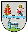
| Blazon : “Divided in silver by a blue wavy bar, top right a gold-coated red miter, top left growing an undressed Aquarius in natural colors with golden hair, pouring blue water from a red jug, below on a green three-mountain a blue church with gold windows and a golden cross. " | |
Culture
There are a total of eight objects on site that are listed . In addition, Deinsberg Castle was once located on the parish of the municipality .
Economy and Infrastructure
economy
From the end of the 18th century, several mercury mines were once located in the municipality: the Altenkopfer mine , the Jakobsburg mine and the Wildenburg mine . Furthermore, small to medium-sized companies have settled here, such as excavator and rubble transports, a car workshop, a hairdresser, a gas station, a tanning salon and a racing company.
Institutions
There is a kindergarten, a primary school and a multi-purpose hall in the village.
traffic
Theisbergstegen is connected to the national road network via the federal road 423 ( Mandelbachtal - Altenglan ). In addition, the bus line 276 operated by Saar-Pfalz-Bus runs through the community and connects it to Kusel, among others. The place has a train station on the opened and since the late 1980s single-track railway line Landstuhl – Kusel , which runs in this area along the Glantal; from 1904 the line in this area was also part of the Glantalbahn, which was gradually shut down from 1961 . The trains connect Kaiserslautern and Kusel with each other. It was also used to transport the porphyry gravel broken from the Remigiusberg before the operation of local freight traffic was given up in 2004.
Theisbergstegen is also on the Glan-Blies cycle path .
Personalities
Sons and daughters of the church
- Paul Tremmel (* 1929), Palatinate dialect poet
- Lothar Emrich (1943–2012), artist
People who worked on site
- Georg Heinrich Vogt (1809–1889), politician and clergyman, was the local pastor from 1839 to 1847
literature
- Literature about Theisbergstegen in the Rhineland-Palatinate state bibliography
Web links
- Site of the local community Theisbergstegen
- Local community Theisbergstegen on the website of the association community Kusel-Altenglan
- Theisbergstegen at www.regionalgeschichte.net
- Godelhausen at www.regionalgeschichte.net
Individual evidence
- ↑ a b State Statistical Office of Rhineland-Palatinate - population status 2019, districts, municipalities, association communities ( help on this ).
- ^ Max Siebert: The Kingdom of Bavaria topographically and statistically in lexicographical and tabular form , Verlag Georg Franz, Munich 1840. S. 189 ( Google Books )
- ↑ Official municipality directory 2006 ( Memento from December 22, 2017 in the Internet Archive ) (= State Statistical Office Rhineland-Palatinate [Hrsg.]: Statistical volumes . Volume 393 ). Bad Ems March 2006, p. 197 (PDF; 2.6 MB). Info: An up-to-date directory ( 2016 ) is available, but in the section "Territorial changes - Territorial administrative reform" it does not give any population figures.
- ↑ State Statistical Office Rhineland-Palatinate - regional data
- ^ The Regional Returning Officer Rhineland-Palatinate: Local elections 2019, city and municipal council elections
- ↑ New clock in place. Die Rheinpfalz, October 4, 2014, accessed on May 17, 2020 .
- ^ The Regional Returning Officer Rhineland-Palatinate: direct elections 2019. see Kusel-Altenglan, Verbandsgemeinde, 36th line of results. Retrieved May 17, 2020 .
- ↑ Stefan Klein makes the choice. Die Rheinpfalz, February 20, 2014, accessed on May 17, 2020 .


