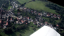
Rutsweiler on the Lauter
| coat of arms | Germany map | |
|---|---|---|

|
Coordinates: 49 ° 34 ' N , 7 ° 37' E |
|
| Basic data | ||
| State : | Rhineland-Palatinate | |
| County : | Kusel | |
| Association municipality : | Lauterecken-Wolfstein | |
| Height : | 200 m above sea level NHN | |
| Area : | 4.32 km 2 | |
| Residents: | 356 (Dec. 31, 2019) | |
| Population density : | 82 inhabitants per km 2 | |
| Postal code : | 67752 | |
| Area code : | 06304 | |
| License plate : | KUS | |
| Community key : | 07 3 36 090 | |
| Association administration address: | Schulstrasse 6a 67742 Lauterecken |
|
| Website : | ||
| Local Mayor : | Dirk Landfried ( SPD ) | |
| Location of the local community Rutsweiler an der Lauter in the district of Kusel | ||
Rutsweiler an der Lauter is a municipality in the Kusel district in Rhineland-Palatinate . It belongs to the Lauterecken-Wolfstein community .
geography
location
Rutsweiler is located in the North Palatinate Uplands . The Selbachmühle residential area also belongs to the community. Neighboring communities are - clockwise - Wolfstein , Kreimbach-Kaulbach , Rothselberg , Eßweiler and Aschbach .
Elevations and waters
The 545.1 meter high Selberg stretches out directly on the border with Rothselberg .
The Lauter forms the eastern boundary of the district. From the left this takes up the Lammelbach in the southern municipality area , within the settlement area also the Selbach from the left .
history
Rutsweiler was first mentioned in a document in 1257 and is one of the oldest settlements in the Lautertal. In the district there used to be a place called Allweiler, which went under in around 1275.
From 1798 to 1814, when the Palatinate was part of the French Republic (until 1804) and then the Napoleonic Empire , the place was incorporated into the canton of Wolfstein . In 1815 the community first belonged to Austria . After the Congress of Vienna , it was added to Bavaria a year later . From 1818 to 1862, "Rutzweiler an der Lauter" - as it was spelled at the time - continued to belong to the Wolfstein canton and was part of the Kusel Land Commissioner , which was then converted into a district office.
In 1939 the place was incorporated into the district of Kusel . After the Second World War , Rutsweiler became part of the then newly formed state of Rhineland-Palatinate within the French occupation zone . In the course of the first Rhineland-Palatinate administrative reform , the community became part of the Wolfstein Association in 1972 . The place has belonged to the Lauterecken-Wolfstein community since 2014.
politics
Municipal council
The municipal council in Rutsweiler consists of eight council members, who were elected by a majority vote in the local elections on May 26, 2019 , and the honorary local mayor as chairman.
mayor
Dirk Landfried became the local mayor of Rutsweiler in 2014. In the direct election on May 26, 2019, he was confirmed in his office for another five years with a share of 72.51% of the votes.
Culture
Cultural monument
The only cultural monument is the historical two-church .
societies
In the community there is a church choir, a rural women’s association, a local branch of the Palatinate Forest Association and a carnival association.
Economy and Infrastructure
traffic
The federal highway 270 runs through Rutsweiler . The state road 370 establishes a connection with Jettenbach and the district road 48 with Immetshausen. The community is connected to the local transport network via the bus route 275 of the Rhein-Neckar transport association , which connects the place with Kusel and Wolfstein .
The Stahlhausen-Rutsweiler stop was located on the Lautertalbahn, which opened in 1883, in Stahlhausen, which belongs to Wolfstein . This served exclusively for passenger traffic and was accordingly run as station type 1 during the time of the Bavarian State Railways. From 1911 the stop was only called Stahlhausen. Three years later it was closed for lack of profitability.
tourism
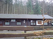
The PWV hut in front of Selberg, owned by the Palatinate Forest Association, has existed in the west of the district since 1985 . The Palatinate High Trail runs through the north-west of the district .
Web links
- Local community Rutsweiler an der Lauter on the website of the Verbandsgemeinde Lauterecken-Wolfstein
- Literature about Rutsweiler an der Lauter in the Rhineland-Palatinate state bibliography
- Rutsweiler an der Lauter at regionalgeschichte.net
Individual evidence
- ↑ State Statistical Office of Rhineland-Palatinate - population status 2019, districts, communities, association communities ( help on this ).
- ↑ State Statistical Office Rhineland-Palatinate (ed.): Official directory of the municipalities and parts of the municipality. Status: January 2019 [ Version 2020 is available. ] . S. 155 (PDF; 3 MB).
- ^ The Regional Returning Officer Rhineland-Palatinate: Local elections 2019, city and municipal council elections
- ↑ Marius Lauer: Rutsweiler / Lauter: Municipal council is about to get to work. Die Rheinpfalz, July 23, 2019, accessed on May 3, 2020 .
- ^ The Regional Returning Officer of Rhineland-Palatinate: direct elections 2019. see Lauterecken-Wolfstein, Verbandsgemeinde, 37th line of results. Retrieved May 3, 2020 .


