
Palatinate High Trail
| Palatinate High Trail | |
|---|---|
 Path marking on Donnersberg |
|
| Data | |
| length | ≈ 112 km |
| location | North Palatinate Uplands |
| Markers | blue-white wave |
| Starting point |
Winnweiler 49 ° 34 ′ 13 ″ N , 7 ° 51 ′ 21.3 ″ E |
| Target point |
Wolfstein 49 ° 35 ′ 3.1 ″ N , 7 ° 36 ′ 21.8 ″ E |
| Type | Prädikatswanderweg |
| Height difference | 539 m |
| The highest point | 687 |
| Lowest point | 148 |
The Palatine Höhenweg in Nordpfälzer mountains is 112 kilometers in length and seven reported daily stages of the third longest predicate trail - after Palatine Weinsteig and the Pfälzerwald path - in the Pfalz ( Rheinland-Pfalz ). The long-distance hiking trail was opened in autumn 2010. One year later, in September 2011, it received its award as a predicate hiking trail .
course
The Palatinate High Trail leads in a semicircle first north around the Donnersberg , the highest mountain in the North Palatinate Highlands and the entire Palatinate , then through the stream valleys northwest of the mountain range. The starting point in the east is Winnweiler , the end point in the west is Wolfstein train station . The hiking route, opened in spring 2011, runs entirely within the North Palatinate Uplands . Its sign / logo, like that of the other two paths, is a mountain slope indicated in a square field with the special features of blue / white and a stylized cloud and an inscribed path name.
Characteristic
With its uphill and downhill stretches, the hiking trail opens up one of the main tourist attractions of the Palatinate, the large, wooded low mountain range of the North Palatinate Uplands . So there are 3300 vertical meters uphill and 3200 downhill; the lowest point is 148 meters in the small town of Meisenheim and the highest is 687 meters on the summit of the Donnersberg. Then, the trail runs partly through the valleys of Alsenz , Moschel , Glan and Lauter that the system of the Rhein inflow Near belong.
Stations and selected sights
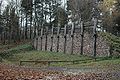
Celtic wall on the Donnersberg
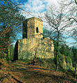
Falkenstein Castle on Donnersberg

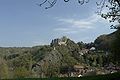
"Moschellandsburg" in the 17th century

Meisenheim's historic old town
Alt-Wolfstein Castle near Wolfstein


Stations and sights are sometimes dealt with in more detail by various interest groups.
- Dannenfels
- Bastion house
- Donnersberg summit
- Keltenwall , Ludwigsturm and transmitter Donnersberg
- Castle ring around the mountain range with Falkenstein and Tannenfels , Wildenstein , Hohenfels and Ruppertsecken
- historic old town
- Alt-Wolfstein and Neu-Wolfstein castles
literature
- Hiking start with a distinction . In: Die Rheinpfalz , LEO season "Spring" . Ludwigshafen April 2011, p. 8-11 .
- Palatinate long-distance hiking trails: Palatinate Weinsteig - Palatinate Forest Trail - Palatinate High Trail (= Roth hiking guide ). 2nd Edition. Bergverlag Rother, Oberhaching 2016, ISBN 978-3-7633-4401-7 .
Web links
Individual evidence
- ↑ Pfälzer Höhenweg hiking trail is opened ( page can no longer be accessed , search in web archives ) Info: The link was automatically marked as defective. Please check the link according to the instructions and then remove this notice. . In: RuhrNachrichten, September 23, 2010. Accessed November 6, 2013.
- ↑ Pfälzer Höhenweg: Figures, data, facts . Rhineland-Palatinate Tourism website. Retrieved November 6, 2013.
- ↑ Pfalz-Touristik: Sport and Fitness. Retrieved on April 8, 2011 (menu item).
- ↑ Hiking portal Pfalz: Hiking. Retrieved on April 8, 2011 (menu item).