Bosenbach
| coat of arms | Germany map | |
|---|---|---|

|
Coordinates: 49 ° 32 ' N , 7 ° 32' E |
|
| Basic data | ||
| State : | Rhineland-Palatinate | |
| County : | Kusel | |
| Association municipality : | Kusel-Altenglan | |
| Height : | 252 m above sea level NHN | |
| Area : | 8.15 km 2 | |
| Residents: | 653 (Dec. 31, 2019) | |
| Population density : | 80 inhabitants per km 2 | |
| Postal code : | 66887 | |
| Area code : | 06385 | |
| License plate : | KUS | |
| Community key : | 07 3 36 009 | |
| LOCODE : | DE B48 | |
| Community structure: | 2 districts | |
| Association administration address: | Marktplatz 1 66869 Kusel |
|
| Website : | ||
| Local Mayor : | Martin full | |
| Location of the local community of Bosenbach in the Kusel district | ||
Bosenbach is a municipality in the Kusel district in Rhineland-Palatinate . It belongs to the community of Kusel-Altenglan .
geography
location
The place is in the North Palatinate Uplands in the so-called Musikantenland in the West Palatinate . The core town is in the east and the Friedelhausen district in the west of the municipality. To the east is Jettenbach , south Niederstaufenbach and west is Altenglan .
Waters
In the west of the municipal area the Reichenbach flows , which takes the Bosenbach from the right . The latter flows through the middle of the settlement area; the Lanzenbach also flows into it from the right .
history
Bosenbach was first mentioned in a document in 945.
From 1798 to 1814, when the Palatinate was part of the French Republic (until 1804) and then part of the Napoleonic Empire , the place was incorporated into the canton of Wolfstein . In 1815 the Bosenbach belonged to Austria . After the Congress of Vienna , it was added to Bavaria a year later . From 1818 to 1862 the community continued to belong to the canton of Wolfstein and was part of the Kusel Land Commissioner , which was then converted into a district office.
In 1939 the place was incorporated into the Kusel district. After the Second World War , Bosenbach became part of the then newly formed state of Rhineland-Palatinate within the French occupation zone . In the course of the first administrative reform in Rhineland-Palatinate , Friedelhausen was incorporated into Bosenbach on January 1, 1971. In 1972 the community became part of the Altenglan Association . The place has belonged to the Kusel-Altenglan community since 2018 .
religion
The Jews living in the village were buried in Hinzweiler .
politics
Municipal council
The council in Bosenbach consists of twelve council members, who in the local elections on May 26, 2019 in a majority vote were elected, and the honorary mayor as chairman.
mayor
Martin Volles became mayor of Bosenbach on June 17, 2019. In the direct election on May 26, 2019, he was elected for five years with 92.15% of the vote.
The predecessor of Volles was Bernd Wagner.
coat of arms
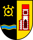
| Reasons for the coat of arms: The church tower is modeled on that of the famous Wolf Church near Bosenbach. The Uranus symbol is reminiscent of the limestone mining in the two communities of Bosenbach and Friedelhausen up to 1971 and, as in the coat of arms, is also located at the tunnel entrance. The wave bar is symbolic of the Bosenbach and at the same time alludes to the place name. The color scheme refers to the former sovereignty in Bosenbach, the red and gold colors stand for the Wildgrafen , the black and gold colors for the Electoral Palatinate . |
Culture and sights
Cultural monuments
Are located on site a total of five properties under conservation are, including the tower of the former Wolf church at the cemetery. The latter is one of the most important cultural monuments in the Palatinate. The wall paintings from the 14th century only exist once more of this type in Italy.
nature
There are three natural monuments in Bosenbach .
Economy and Infrastructure
economy
Bosenbach once belonged to the catchment area of the West Palatinate hiking musicians .
traffic
State road 367 , which leads from Altenglan to Kaiserslautern, runs through the Friedelhausen district . State road 370 , which runs through the town center to Kreimbach-Kaulbach , flows into this . The district road 56 also establishes a connection with Niederstaufnebach. In the southwest is the A 62 .
Bosenbach is connected to the local transport network via the bus route 275 of the Rhein-Neckar transport association , which connects the place with Kusel and Wolfstein. In Altenglan there is a train station on the Landstuhl – Kusel railway line .
Facilities
There is a kindergarten and an outdoor pool in Bosenbach.
tourism
The hut on Sauling , which is operated by the local branch of the Palatinate Forest Association , is located in the municipality .
literature
- Literature about Bosenbach in the Rhineland-Palatinate State Bibliography
Web links
- Internet presence of the local community Bosenbach
- Local community Bosenbach on the website of the association community Kusel-Altenglan
Individual evidence
- ↑ State Statistical Office of Rhineland-Palatinate - population status 2019, districts, communities, association communities ( help on this ).
- ↑ Official municipality directory 2006 ( Memento from December 22, 2017 in the Internet Archive ) (= State Statistical Office Rhineland-Palatinate [Hrsg.]: Statistical volumes . Volume 393 ). Bad Ems March 2006, p. 172 (PDF; 2.6 MB). Info: An up-to-date directory ( 2016 ) is available, but in the section "Territorial changes - Territorial administrative reform" it does not give any population figures.
- ^ The Regional Returning Officer Rhineland-Palatinate: Local elections 2019, city and municipal council elections
- ↑ a b Eric Sayer: Bosenbach: Lot decides on the second alderman. Die Rheinpfalz, June 18, 2019, accessed on May 10, 2020 .
- ^ The Regional Returning Officer Rhineland-Palatinate: direct elections 2019. see Kusel-Altenglan, Verbandsgemeinde, sixth result line. Retrieved May 10, 2020 .
- ↑ Description of the coat of arms on the website of the former municipality of Altenglan ( Memento from August 1, 2012 in the Internet Archive ), accessed on October 1, 2012.


