
Langweiler (near Lauterecken)
| coat of arms | Germany map | |
|---|---|---|

|
Coordinates: 49 ° 40 ' N , 7 ° 32' E |
|
| Basic data | ||
| State : | Rhineland-Palatinate | |
| County : | Kusel | |
| Association municipality : | Lauterecken-Wolfstein | |
| Height : | 288 m above sea level NHN | |
| Area : | 4.16 km 2 | |
| Residents: | 237 (Dec. 31, 2019) | |
| Population density : | 57 inhabitants per km 2 | |
| Postal code : | 67746 | |
| Area code : | 06788 | |
| License plate : | KUS | |
| Community key : | 07 3 36 057 | |
| Association administration address: | Schulstrasse 6a 67742 Lauterecken |
|
| Website : | ||
| Local Mayor : | Roland Edinger | |
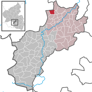
| Location of the local community Langweiler in the district of Kusel | ||
  |
||

Langweiler is a municipality in the Kusel district in Rhineland-Palatinate . It belongs to the Lauterecken-Wolfstein association.
geography
Langweiler is located on the Jeckenbach in the West Palatinate between the Palatinate Forest and the Hunsrück . Around 50 percent of the municipal area is forested. To the north is Sien , east Merzweiler , south Homberg and east is Unterjeckenbach . Langweiler also includes the Ölmühle, Hof vor Fläsling and Tiefentaler Mühle residential areas .
history
The place was first mentioned in a document in 1276. In the Middle Ages the village was called "Landweiler", probably after a Franconian named Lando. In the 16th century it was renamed and reinterpreted as "Langweiler". During the Thirty Years War , the village was completely destroyed by Croatian mercenaries and remained uninhabited for 12 years.
In 1816 Langweiler came to the Principality of Lichtenberg , a newly created exclave of the Duchy of Saxe-Coburg-Saalfeld and, from 1826, the Duchy of Saxe-Coburg and Gotha . With this it fell to Prussia in 1834 , which created the St. Wendel district from this area . After the main part was separated from the newly created Saar area , the remaining district of Sankt Wendel-Baumholder was created in 1920 , to which the place belonged until 1937, when it was incorporated into the Birkenfeld district.
The former school now serves as a community center.
On October 13, 1939, a British military plane crashed near Langweiler. The pilot survived and was taken to a hospital by the locals. Thirty years later, Colonel Day returned to visit the site of his crash and rescue.
politics
Municipal council
The council in Langweiler consists of six council members, who in the local elections on May 26, 2019 in a majority vote were elected, and the honorary mayor as chairman.
mayor
Roland Edinger became the local mayor of Langweiler on July 2, 2019. In the direct election on May 26, 2019, he was elected for five years with 69.23% of the vote. His long-term predecessor Berthold Janß did not run again in 2019.
traffic
Federal highway 270 runs to the west . In Lauterecken there is a station of the Lautertalbahn .
See also
Web links
- Local community Langweiler on the website of the Verbandsgemeinde Lauterecken-Wolfstein
- Boring at regionalgeschichte.net
- Literature about bores in the Rhineland-Palatinate state bibliography
Individual evidence
- ↑ State Statistical Office of Rhineland-Palatinate - population status 2019, districts, communities, association communities ( help on this ).
- ↑ State Statistical Office Rhineland-Palatinate (ed.): Official directory of the municipalities and parts of the municipality. Status: January 2019 [ Version 2020 is available. ] . S. 154 (PDF; 3 MB).
- ^ The Regional Returning Officer Rhineland-Palatinate: Local elections 2019, city and municipal council elections.
- ↑ a b Rundschau für das Glan and Lautertal: From the local council meeting on July 2nd, 2019. Linus Wittich Medien GmbH, Official Gazette, Edition 33/2019, accessed on May 1, 2020 .
- ^ The Regional Returning Officer Rhineland-Palatinate: direct elections 2019. see Lauterecken-Wolfstein, Verbandsgemeinde, 23rd line of results. Retrieved May 1, 2020 .
- ^ Sabrina Schreiner: Portrait: Roland Edinger, the new local mayor of Langweiler. August 6, 2019, accessed May 1, 2020 .

Adenbach | Albessen | Altenglan | Altenkirchen | Aschbach | Bedesbach | Blaubach | Börsborn | Bosenbach | Breitenbach | Bridges (Palatinate) | Buborn | Cronenberg | Deimberg | Dennweiler-Frohnbach | Dittweiler | Dunzweiler | Ehweiler | Oiling | Elzweiler | Erdesbach | Eßweiler | Etschberg | Föckelberg | Frohnhofen | Ginsweiler | Glan-Münchweiler | Glan bridges | Semolina | Grumbach | Haschbach am Remigiusberg | Hausweiler | Hefersweiler | Heinzenhausen | Henschtal | Herchweiler | Herren-Sulzbach | Herschweiler-Pettersheim | Hinzweiler | Hohenöllen | Homberg | Hoppstädten | Horschbach | Hüffler | Jettenbach | Kappeln | Kirrweiler | Konken | Körborn | Kreimbach-Kaulbach | Krottelbach | Kusel | Langenbach | Boring | Lauterecken | Lohnweiler | Matzenbach | Medard | Merzweiler | Nanzdietschweiler | Nerzweiler | Neunkirchen am Potzberg | Lower albums | Niederstaufenbach | Nussbach | Top albums | Oberstaufenbach | Oberweiler im Tal | Oberweiler-Tiefenbach | Odenbach | Offenbach-Hundheim | Ohmbach | Pfeffelbach | Quirnbach / Palatinate | Rammelsbach | Rathsweiler | Rehweiler | Reichweiler | Reipoltskirchen | Relsberg | Rothselberg | Ruthweiler | Rutsweiler am Glan | Rutsweiler an der Lauter | Saint Julian | Schellweiler | Schönenberg-Kübelberg | Selchenbach | Steinbach am Glan | Thallichtenberg | Theisbergstegen | Ulmet | Unterjeckenbach | Delusional | Forest black | Welchweiler | Wiesweiler | Wolfstein