Nanzdietschweiler
| coat of arms | Germany map | |
|---|---|---|

|
Coordinates: 49 ° 27 ' N , 7 ° 26' E |
|
| Basic data | ||
| State : | Rhineland-Palatinate | |
| County : | Kusel | |
| Association municipality : | Upper Glantal | |
| Height : | 237 m above sea level NHN | |
| Area : | 9.82 km 2 | |
| Residents: | 1141 (Dec. 31, 2019) | |
| Population density : | 116 inhabitants per km 2 | |
| Postal code : | 66909 | |
| Area code : | 06383 | |
| License plate : | KUS | |
| Community key : | 07 3 36 064 | |
| Community structure: | 3 districts | |
| Association administration address: | Rathausstrasse 8 66901 Schönenberg-Kübelberg |
|
| Website : | ||
| Local Mayor : | Annette Filipiak-Bender ( CDU ) | |
| Location of the local community Nanzdietschweiler in the Kusel district | ||
Nanzdietschweiler is a municipality in the Kusel district in Rhineland-Palatinate . It was created in 1969 when the towns of Nanzweiler , Dietschweiler and Nanzdiezweiler were amalgamated to form this new municipality as part of the Rhineland-Palatinate administrative reform . In the following period, Nanzdietschweiler developed primarily into a residential community. Nanzdietschweiler has been part of the Oberes Glantal community since 2017 , and before that it was part of the Glan-Münchweiler community .
geography
Nanzdietschweiler is located in the upper Glan Valley at the transition from the Landstuhler Bruch to the North Palatinate Bergland . The place is between 220 m and 250 m above sea level. NHN . The highest elevations in the district reach 384 m above sea level. NHN . The place is characterized by forests, meadows and the species-rich Glan that are inviting for hiking and flow through the bird and nature reserve "Heimerbrühl", which is interesting for ornithologists.
The community used to be divided into three parts: Nanzweiler, Dietschweiler and Nanzdiezweiler. In addition there was a cross, which is counted to Dietschweiler. The border ran with the Glan (Nanzweiler / Nanzdiezweiler) and at the level of today's sports field (Nanzweiler / Dietschweiler). The district of Kreuz with the old grain mill, the Dietschweiler Mühle , is an exception. Although it is on the right side of the Glans (Nanzdiezweiler), it belongs to Dietschweiler.
182 hectares of the district are forested and 26 hectares are populated.
history
Nanzweiler was first mentioned in 1350 as Nantzwilre , Dietschweiler in 1436 as Dyetzwiller . The settlement area of both places extended on both sides of the Glans. The side to the left of the Glans was subordinate to the Hornbach monastery and from the 16th century to the lords and later counts of the Leyen . The side to the right of the Glans was an imperial estate and was under the Electoral Palatinate from the 15th century . To the right of the Glans, two further communities Nanzweiler and Diezweiler developed, which were merged into Nanzdiezweiler in 1816.
From 1798 to 1814, when the Palatinate was part of the First French Republic (until 1804) and then part of the First French Empire , the places on the right of the Glans were in the canton of Landstuhl in the Donnersberg department and the places on the left of the Glans in the canton of Waldmohr in Saardepartement incorporated. In 1816 they came to the Kingdom of Bavaria . The division into the two cantons remained in place until the middle of the 19th century, but from 1818 on both cantons belonged together to the Homburg Land Commissioner .
In the course of the Rhineland-Palatinate administrative reform, the new local community Nanzdietschweiler was formed on June 7, 1969 from the three previously independent communities of Dietschweiler, Nanzdiezweiler and Nanzweiler. The name of the new municipality is made up of elements from all three districts.
- Population development
The development of the number of inhabitants in relation to what is today the municipality of Nanzdietschweiler; the values from 1871 to 1987 are based on censuses:
|
|
politics
Municipal council
The local council in Nanzdietschweiler consists of 16 council members, who were elected in the local elections on May 26, 2019 , and the honorary local mayor as chairman.
The distribution of seats in the municipal council:
| choice | SPD | CDU | WGR | total |
|---|---|---|---|---|
| 2019 | 4th | 8th | 4th | 16 seats |
| 2014 | 6th | 10 | - | 16 seats |
| 2009 | 6th | 10 | - | 16 seats |
| 2004 | 7th | 9 | - | 16 seats |
- WGR = Voting Group Reiss
mayor
Annette Filipiak-Bender (CDU) became the local mayor of Nanzdietschweiler on August 16, 2019. In the direct election on May 26, 2019, she was elected for five years with a share of 62.70% of the vote.
Martin Holzhauser (CDU) had held the office as the predecessor of Annette Filipiak-Bender for 15 years, but did not start again in 2019.
coat of arms
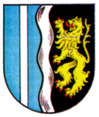
| Blazon : "Split by a silver wave pole of blue and black, on the right a silver pole, on the left a red armored and tongued golden lion." | |
| Foundation for the coat of arms: It was awarded in 1980 by the Neustadt district government . The lion comes from the coat of arms of the Electoral Palatinate , which formerly ruled Nanzdiezweiler. The silver post refers to the Counts von der Leyen , who owned Dietschweiler and Nanzweiler. The wave pole symbolizes the glan that connects the previously independent places. |
The flag is split blue-white-blue in a ratio of 2: 5: 2.
Parish partnership
Nanzdietschweiler has since 1985 a local partnership with the community Butten in the Bas-Rhin in Alsace / France.
Culture
Kerwe is celebrated on the second weekend in September in Dietschweiler and on the third weekend in Nanzweiler .
Nanzdietschweiler has a primary school that is run by the Verbandsgemeinde and is located in the Dietschweiler district and has four classes. The schools in Nanzweiler and Nanzdiezweiler have since been closed. There is also a kindergarten in the community. There are various attractions in this place, such as B. the Dietschweiler mill. Not far from there you can see the historic washing facility, which is located in the immediate vicinity of the old railway line, the current Glan-Blies-Weg .
societies
- music Society
- FCK fan club "Trafo"
- Volunteer firefighter
- Wild boar club
- Sports club
- "Freischütz" shooting club
- Palatinate Forest Association
- Fruit and horticultural association
- Choral societies
- Dietschweiler Kerwe eV
traffic
Street
State road 358 , which runs from Glan-Münchweiler to Bruchmühlbach, runs through Nanzweiler and Dietschweiler . District road 10 coming from Börsborn ends in Dietschweiler, district roads 54 , 58 and 59 also run through Nanzweiler .
rail
The places that belong to the municipality today were connected to the railway network in 1904 with the opening of the Glantalbahn . The station in question was initially called Dietschweiler-Nanzweiler before it was renamed Dietschweiler in 1912 . At the beginning of the 1960s, the Nanzweiler stop was opened one kilometer north , which should revitalize the said railway line in the southern section Homburg - Glan-Münchweiler . It was closed again in the late 1970s. Passenger traffic was stopped in 1981; since the freight traffic between Schönenberg-Kübelberg and Glan-Münchweiler had already been discontinued, it was henceforth without regular traffic. The tracks were dismantled at the end of the 1980s. In 2002, the Glan-Blies-Weg , which was completed in 2006 in full, was opened on the route .
See also
literature
- Literature about Nanzdietschweiler in the Rhineland-Palatinate state bibliography
Web links
- Internet presence of the local community Nanzdietschweiler
- Local community Nanzdietschweiler on the website of the Upper Glantal community
- Information on the Dietschweiler district
- Sights in and around Nanzdietschweiler
Individual evidence
- ↑ State Statistical Office of Rhineland-Palatinate - population status 2019, districts, communities, association communities ( help on this ).
- ↑ a b c d e f g Nanzdietschweiler. In: regionalgeschichte.net. Retrieved March 21, 2013 .
- ↑ Martin Dolch, Albrecht Greule: Historisches Siedlungsnamesbuch der Pfalz . Speyer, Publishing House of the Palatinate Society for the Advancement of Science 1991, p. 327
- ↑ Martin Dolch, Albrecht Greule: Historisches Siedlungsnamesbuch der Pfalz . Speyer, Publishing House of the Palatinate Society for the Advancement of Science 1991, p. 104
- ↑ Official municipality directory 2006 ( Memento from December 22, 2017 in the Internet Archive ) (= State Statistical Office Rhineland-Palatinate [Hrsg.]: Statistical volumes . Volume 393 ). Bad Ems March 2006, p. 188 (PDF; 2.6 MB). Info: An up-to-date directory ( 2016 ) is available, but in the section "Territorial changes - Territorial administrative reform" it does not give any population figures.
- ↑ State Statistical Office Rhineland-Palatinate - regional data
- ^ The Regional Returning Officer for Rhineland-Palatinate: City Council Election 2019 Nanzdietschweiler. Retrieved May 7, 2020 .
- ^ The Regional Returning Officer Rhineland-Palatinate: Municipal elections 2014, city and municipal council elections
- ↑ Constituent meeting on August 16, 2019. Nanzdietschweiler community, accessed on May 7, 2020 .
- ^ The Regional Returning Officer Rhineland-Palatinate: direct elections 2019. see Oberes Glantal, Verbandsgemeinde, 15th row of results. Retrieved May 7, 2020 .
- ^ Reinhard Schmidt: Nanzdietschweiler: Forsteinrichtungswerk relies on so-called forest refuges. Last local council meeting before local elections. Die Rheinpfalz, May 22, 2019, accessed on May 7, 2020 .


