Eßweiler
| coat of arms | Germany map | |
|---|---|---|

|
Coordinates: 49 ° 34 ' N , 7 ° 34' E |
|
| Basic data | ||
| State : | Rhineland-Palatinate | |
| County : | Kusel | |
| Association municipality : | Lauterecken-Wolfstein | |
| Height : | 272 m above sea level NHN | |
| Area : | 8.09 km 2 | |
| Residents: | 380 (Dec. 31, 2019) | |
| Population density : | 47 inhabitants per km 2 | |
| Postal code : | 67754 | |
| Area code : | 06304 | |
| License plate : | KUS | |
| Community key : | 07 3 36 023 | |
| Association administration address: | Schulstrasse 6a 67742 Lauterecken |
|
| Website : | ||
| Local Mayor : | Peter Gilcher | |
| Location of the local community Eßweiler in the Kusel district | ||
Eßweiler [ ˈɛsvaɪlɐ ] is a municipality in the Kusel district in Rhineland-Palatinate and belongs to the Lauterecken-Wolfstein association.
Eßweiler was first mentioned in a document in 1296 and gave its name to the medieval administrative complex Eßweiler Tal . The Sprengelburg was built around 1300, the ruin of which has been a listed building since 1983. In the 19th century Eßweiler was one of the main places of the West Palatinate touring musicians , around 300 musicians came from the place. Today Eßweiler is a pure residential community, a majority of the around 400 residents work in the surrounding cities. The Luftsportverein Eßweiler operates a glider airfield here.
geography
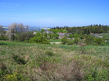
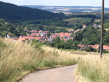
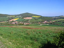
Eßweiler has an area of 8.1 square kilometers. 39.5% of the district are used for agriculture, 13.9% are settlement and traffic areas, 46.1% are forest and 0.5% are water areas. The place is about 25 kilometers north of Kaiserslautern , about 15 kilometers east of Kusel and about four kilometers west of Wolfstein at the foot of the Königsberg . In the center of the village, the Breitenbach and the Jettenbach merge to form the Talbach , which flows into the Glan in Offenbach-Hundheim . Around Eßweiler are some of the highest mountains in the Kusel district : the Königsberg (568 m), the Selberg (546 m), the Potschberg (498 m), the Bornberg (520 m) and the Herrmannsberg (536 m).
The Königsbergerhof, Oberste Mühle and Schneeweiderhof residential areas also belong to Eßweiler .
history
The origin of the name is said to be a " hamlet of Ezzo (or Azzo)". Originally the place on Königsberg was in today's Gewanne Kirchwiese, in earlier times the remains of the wall were also found there. The first known mention of Eßweiler at the present time is a document from the Counts of Zweibrücken from 1296, in which the place is mentioned as Esewilr . But the area was already settled:
Until Roman times
Several Stone Age finds were made in the districts of Eßweiler and Rothselberg . Later Celts and Romans settled here . In 1904 a silver spoon decorated with doves, grapes and vine leaves and the inscription "Lucilianae vivas" was found. The origin is Roman, around the 4th century. The spoon is now in the Palatinate History Museum in Speyer . In 2002/2003 employees of the Office for Archaeological Monument Preservation carried out excavations on Trautmannsberg to inspect and secure a Roman estate. Immediately next to it ceramic finds and storage pits from pre-Celtic times (around 800 BC) were uncovered. The remains of a Roman mountain sanctuary were found on the Potschberg at the beginning of the 20th century.
middle Ages
In the Middle Ages and early modern times, Eßweiler belonged to the Eßweiler Tal complex , a unit to which the villages of Eßweiler, Oberweiler im Tal , Hinzweiler , Nerzweiler , Hundheim , Aschbach , Horschbach , Elzweiler and Hachenbach belonged. A cleared area that covered most of the Eßweiler valley was given to the Prüm abbey in the Eifel between 868 and 870 . Later, the entire valley was administered by the County of Veldenz , which split off from the Wildgrafen . The seat of the administration was initially Nerzweiler, between 1443 and 1477 the official seat was moved to Hundheim. The Sprengelburg (Springeburg) was built around 1300 between Eßweiler and Oberweiler in the valley . However, it did not last long and was soon destroyed again. The lords of the castle at that time were the knights of Mülenstein, feudal men of the wild counts . Over the years, however, the political unity of the Eßweiler valley fell apart , so that in the 16th century 14 feudal lords ruled the villages. The highest landlords and feudal lords at that time were the Junkers von Scharfenstein. They were feudal men of the wild counts and provided for a common administration and jurisdiction. In 1595 the entire Eßweiler valley came to the Duchy of Pfalz-Zweibrücken . Eßweiler stayed there until the conquest of the left bank of the Rhine by French revolutionary troops after 1792, while some of the villages fell back to the Wildgraves in 1755 .
Early modern age
The wars of the 17th and 18th centuries caused great devastation and loss of the population. In the Thirty Years' War there was no major fighting here, but the area was crossed, plundered and devastated several times by various armies, including a mill in Eßweiler (it was rebuilt in 1661). Between 1635 and 1638 the plague also raged , which had also occurred sporadically before. In the following disputes, the region was also a passage area for various troops, in the Franco-Dutch War and the Palatinate War of Succession , the region was occupied by French troops, and there were repeated looting and devastation. In 1768 only 141 families lived in the "Eßweiler Tal". In the years that followed, many residents emigrated to North and South America and Eastern Europe.
Construction of a church began in Eßweiler in 1733. In 1745 there were again two mills in the village (both buildings are still there, the mill in Mühlgasse was in operation until the 1970s). In 1750 a fire caused great damage to the place.
19th century
The outbreak of the French Revolution brought with it again armed conflicts. After the annexation of the left bank of the Rhine , Eßweiler belonged to France since 1798 and was assigned to the canton Wolfstein in the Département du Mont-Tonnerre (Donnersberg). From 1816 until the end of the First World War , Eßweiler belonged to the Kingdom of Bavaria , from 1918 to 1946 then to the Free State of Bavaria.
In the 19th century the population increased sharply, in 1803 there were 464 inhabitants, then in 1836 614 (28 Catholics, 525 Protestants and 61 Jews) and in 1867 716 inhabitants (14 Catholics, 617 Protestants and 85 Jews). However, economic hardship and repeated famines led to several waves of emigration in the 18th and 19th centuries , which lasted into the 1920s. Several branches of the Gilcher family emigrated from Eßweiler to Brazil and the USA.
The origin of the West Palatinate touring musicians dates back to the 1830s, its heyday was between 1850 and the First World War. Eßweiler was one of the main places in the Musikantenland , around 300 musicians moved from here all over the world from the middle of the 19th century. In contrast to the permanent emigration, most of the traveling musicians returned here again and again, although their travels could sometimes take several years. Well-known musicians from Eßweiler are:
- Michael Gilcher (1822–1899), trumpeter, traveled to England and the USA, later was mayor of Eßweiler.
- Hubertus Kilian (1827–1899), trombonist, traveling a. a. to Australia, China and the USA.
- Rudolph Schmitt (1900-1993), clarinetist. Rudolph Schmitt stayed in the USA and became a sought-after clarinetist in several symphony orchestras.
Since 1900
In 1907 the first water pipe was laid. The water came from a spring on the Trautmannsberg. It was in operation until the 1980s, then Eßweiler, and in the 1990s also the Schneeweiderhof, was connected to a supra-regional water supply via pipelines. It was connected to the power grid from 1924.
The inscriptions on the memorial show 13 fallen and 2 missing soldiers for the First World War, nothing is known about the destruction in the place or losses in the civilian population. After the end of the First World War, Eßweiler belonged to the Free State of Bavaria until 1946 . The houses of the last two Jewish families were devastated during the Reichspogromnacht , and shortly afterwards the three remaining Jewish community members were deported (see also below ). The place survived the Second World War relatively unscathed, only one building was damaged by an American tank. However, according to the memorial inscriptions, 51 men died as soldiers. And in February 1945 a serious accident occurred when children used left-behind ammunition parts to play with. Five children died in the explosion and several others were injured, some seriously.
Eßweiler has been part of the state of Rhineland-Palatinate since 1946 . With the establishment of the Wolfstein community on January 1, 1972, the mayor's office of Eßweiler, which was also responsible for the neighboring community of Oberweiler im Tal, was dissolved. Since July 1, 2014, the community has been part of the newly established Lauterecken-Wolfstein association.
religion
Christianity
The silver spoon from Roman times found in 1904 was taken as evidence of an early Christianization of the population at that time , because the doves pecking at grapes, with which it is decorated, were referred to as a typical Christian emblem in the description of the find. At least it shows that contacts with Christianity already existed at that time . Until the Reformation , Eßweiler belonged to a common parish like all other villages in the Eßweiler valley . The parish church was the Hirsau church near Hundheim , built in the 12th century . In 1544 the places Eßweiler, Oberweiler im Tal and Hinzweiler were combined to form the parish of Hinzweiler, the church there became a parish church and the pastor also lived there . This coincided with the conversion of the gentlemen of the time to the Lutheran faith . In 1595 the valley became the property of Pfalz-Zweibrücken . With that one had to switch to the reformed faith . In 1601 Eßweiler came to the parish of Bosenbach . It was united with the parish of Hinzweiler at the end of the Thirty Years War. The community members were looked after again from Hinzweiler. The Lutheran faith had not completely disappeared, however, in 1709 a separate Lutheran parish was founded for the villages of the Essweiler Valley . 1746 Eßweiler came back to the parish of Bosenbach. This was not changed again until 1971, Eßweiler came to the parish of Rothselberg, to which it still belongs to this day along with the places Rothselberg and Kreimbach-Kaulbach .
In 1733 the construction of its own church began in Eßweiler. At that time, a separate cemetery was set up after there was originally only one cemetery for all places in the Eßweiler Valley near the Hirsau Church in Hundheim.
The Jewish community
In 1688 four Jewish families lived in Eßweiler. Their number has increased steadily over the years. In the 1860s, Eßweiler had one of the largest Jewish communities in the Kusel district ; in 1867, 85 Jews lived here . (Population figures from). The number decreased in the following years just as continuously, many residents moved to the larger cities. On January 24, 1906, the Israelite religious community in Eßweiler was dissolved and the remaining Jewish citizens, the two families of Isidor and his brother Sigmund Rothschild, joined the Jewish community of Kusel.
During the Reichspogromnacht in 1938, members of the SA from Altenglan and Theisbergstegen , reinforced by some supporters of the NSDAP from Jettenbach, as well as SA members from Kusel , who were traveling in the district and destroying Jewish property, broke into their houses and devastated them. Shortly afterwards, the remaining family members, the widower Isidor and his brother Sigmund Rothschild with his wife Blondine, were deported. The couple probably died in Theresienstadt . Two of her four daughters were also murdered in the concentration camps . The other two daughters and sons of Isidor Rothschild escaped and later lived in the USA .
There was a synagogue in town, popularly called the Jewish School . It was mentioned as early as 1789. The street in which it was located is still called Judengasse by the population today . The synagogue was leased for residential purposes in 1902 and auctioned off in 1907. The building is still standing, but it is used as a residential building and no longer contains any evidence of its original use. The remnants of a mikveh were found in the neighboring building during renovation work in the 1960s .
The dead were buried in the Jewish cemeteries in Hinzweiler, later in Kaiserslautern. In 1904 the cemetery in Hinzweiler became the property of the Jewish community of Eßweiler.
Religious affiliation numbers
As of May 31, 2009, the 431 residents with their main residence in Eßweiler belonged to the following denominations:
| Denomination | number | percent |
| evangelical | 330 | 76.57% |
| Roman Catholic | 38 | 8.82% |
| Free religious parish of the Palatinate | 2 | 0.46% |
| other | 3 | 0.70% |
| no | 48 | 11.14% |
| without specification | 10 | 2.32% |
politics and society
Municipal council
The council in Eßweiler consists of eight council members, who in the local elections on May 26, 2019 in a majority vote were elected, and the honorary mayor as chairman.
Local mayor
Peter Gilcher was again mayor of Eßweiler in July 2019 . In the direct election on May 26, 2019, he was elected for five years with 58.45% of the vote. Gilcher had previously held the office from July 2004 until his resignation at the end of 2016. From 2017 to 2019 Monika Riesinger was elected mayor.
coat of arms
The coat of arms was approved on October 13, 1982 by the district government of Rheinhessen-Pfalz . The background is gold in color. A division is made by a broad, blue wavy line running from top left to bottom right. In the upper field there is a red castle with a tower; in the lower field two crossed stone hammers can be seen. The coat of arms symbolizes the Talbach, the Sprengelburg and the quarries in the Schneeweiderhof district.
Population figures
Population numbers
On December 31, 2018, 397 people had their main residence in Eßweiler, 199 (50.13%) were male and 198 (49.87%) were female. The proportion of foreigners was 5.04%.
| year | 1609 | 1803 | 1836 | 1867 | 1893 | 1905 | 1938 | 1969 | 1974 | 1977 | 1980 | 2007 | 2009 | 2011 | 2018 |
|---|---|---|---|---|---|---|---|---|---|---|---|---|---|---|---|
| Residents | 144 | 464 | 614 | 716 | 682 | 644 | 672 | 666 | 612 | 599 | 602 | 453 | 431 | 418 | 397 |
The population figures of the 19th century include a high proportion of Jewish citizens, 61 Jews lived here in 1836 and then 85 in 1867. The first half of the 20th century saw immigration mainly to the Schneeweiderhof through the quarries there. Since the middle of the 20th century, the population has been falling continuously.
age structure
Based on the population figures as of May 9, 2011 (last census), Eßweiler shows the following age structure:
| Age in years | 0-9 | 10-19 | 20-29 | 30-39 | 40-49 | 50-59 | 60-69 | 70-79 | from 80 |
|---|---|---|---|---|---|---|---|---|---|
| Share 2009 | 6.70% | 12.68% | 7.66% | 10.05% | 16.27% | 18.42% | 10.76% | 13.40% | 4.31% |
Sights and culture
Buildings
The Sprengelburg ruins
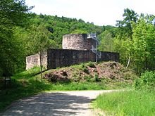
The Sprengelburg (or Springeburg) is located between Eßweiler and Oberweiler in the valley on a foothill of the Königsberg directly on the state road 372 . It was, to judge from the existing Bauresten, built around 1300 and soon again in a feud destroyed because the lords, the knights Mülenstein as robber barons were fought. Until the 1970s, only the name of the place, by the old castle , indicated the castle, all building remains were hidden under a mound of earth overgrown with trees. The current appearance of the ruin is the result of restoration measures that were initiated by the State Office for the Preservation of Monuments in Rhineland-Palatinate in Speyer and carried out from 1976 to the mid-1980s. The ruin has been a listed building since 1983 .
The colony
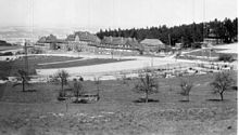
Up to the middle of the 20th century, up to 500 people were employed in the quarries on the Schneeweiderhof . They came from the surrounding villages and made the way up the mountain, sometimes five to six kilometers, on foot. Between 1922 and 1924 a workers' settlement was built on the Schneeweiderhof by the owner of the quarries, Basalt AG, Linz am Rhein, from the basalt stones found there. It is popularly called the colony . The complex consists of a three-storey main building and two wing buildings that are a little closer to the street. The courtyards behind the complex can be reached through arched passageways. There were stables for goats and chickens. The exterior of the building complex has largely been preserved in its original form. Many apartments are no longer inhabited.
Protestant church
The Evangelical Church is in the center of the village . The nave , which was built in 1733, is still there today; in 1865 the dilapidated roof turret was replaced by an attached tower . Inside there is an organ that was delivered by EF Walcker, Ludwigsburg , in 1869 and has been preserved unchanged.
education and parenting
In 1936 a new school building was built on the outskirts of Oberweiler im Tal, previously the pupils of the Eßweiler elementary school were housed in a building in the center of the village and also in the town hall. This new schoolhouse was used until 2002 after several renovations. Between 1952 and 1965 there was a school on the Schneeweiderhof. Since the beginning of the 2002 school year, a new, modern school building in Jettenbach has been available for the pupils of the Königsland elementary school from Eßweiler, Rothselberg, Jettenbach , Oberweiler im Tal and Hinzweiler. It replaced the old school houses in Eßweiler, Jettenbach and Rothselberg. Secondary schools in the area are the Realschule plus Lauterecken-Wolfstein, the Realschule plus Kusel, the grammar schools in Kusel and Lauterecken as well as the school center in Kusel on the Roßberg with a secondary school, vocational school and business high school . The closest universities are the Kaiserslautern University of Applied Sciences and the Kaiserslautern University of Technology . Together with the neighboring community of Rothselberg, the Spatzennest kindergarten has been operated in Rothselberg since 1997 .
societies
The oldest club in Eßweiler is the Gesangverein 1888 Eßweiler e. V. According to an inventory of the German Choir Association from 1942, it was founded in 1888 as a men's choir. In the beginning, conductors were usually the local school teachers. In 1925, a second men's choir was founded with the Arbeiter Gesang- undützungsverein , the original club was therefore popularly called a civil choir . After the National Socialists came to power in 1933, the two associations were merged in the course of the Gleichschaltung . The new club was still active until 1942. In 1946 the association was re-established, which was not easy because the French military administration and the like. a. demanded a French translation of the association's statutes. From the mid-1960s, it became increasingly difficult to find young singers. Therefore, a women's choir was founded in 1967 and the men's choir was converted into a mixed choir. However, this only solved the problem for a short time, so that in the 1990s a choir partnership with the Horschbach Choral Society was formed. Oswald Henn, who was a conductor from 1925, at that time at the Arbeitergesangverein, until 1981, is of great importance to the association. From 1902 until the end of the 1960s, the choral society also organized theater performances. This tradition continued in 1998 with the formation of the theater company .
In 1924 the civil sports club Eßweiler was founded in Eßweiler . In 1928 a gymnastics department and a girls' team were added and today's name Turn- und Sportverein Eßweiler was created. After the Second World War, the club was re-established as a football club, but first, due to a lack of players, they had to enter into a syndicate with Rothselberg and Kreimbach-Kaulbach. From 1949 there were enough players again for a team of their own. In 1957 the team was promoted to the B-Class Kusel. In the 1960s, a lack of young talent became noticeable, the team was relegated and since 1968 there has been a syndicate with the Rothselberg sports club. Since 1988, the SG Eßweiler-Rothselberg has been back in the B-Class and Kusel district league. In 2015 there was another merger to form SG Jettenbach-Eßweiler-Rothselberg.
The rural women's association has been active in the community since 1962 . At the beginning of the 1970s, the Heimat- und Verkehrsverein was founded, which runs the Landscheidhütte and to which the theater group also belongs. To support the volunteer fire brigade , the fire brigade support association “St. Florian “Eßweiler founded. The tradition of Eßweiler as a musicians' village is continued by the music association Die Talbachmusikanten , which was founded in 1988 and to which the Eßweiler / Jettenbach youth orchestra also belongs. Other associations are the geriatric and nursing care association , the local SPD association and the air sports association Eßweiler (formerly Landstuhl) e. V. .
Glider airfield
Above the village is the glider airfield Eßweiler , which is operated by the air sports club Eßweiler . The course was built in 1963 and is approved for gliders, motor gliders and UL. Piston-powered aircraft with a take-off weight of up to two tons are only permitted with a glider tow coupling.
Economy and Infrastructure
Jobs
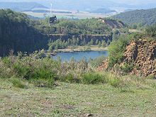
Until the 20th century, agriculture was the livelihood of the population of Eßweiler. In 1833 the following areas were cultivated: 1,365 acres of arable land, 210 acres of potato cultivation, 7 acres of garden land, 133 acres of fodder herbs and 314 acres of vegetables. Nothing is known about the size of the pastures. From around 1830, traveling musicians became increasingly important in the West Palatinate and Eßweiler became one of the main places in the musicians' country (see above ). In the 18th and 19th centuries, several mines were built around Eßweiler, especially in Königsberg, in which they dug for mercury , barite , iron ore and coal . The hard stone deposits on the Schneeweiderhof were of greater importance for Eßweiler . From 1870 the first quarries were built there by Eßweiler citizens , in which mainly paving stones were made. In 1914 the quarries that z. B. Rübezahl , Hindenburg or Bismarck were called, bought by Basalt AG, Linz am Rhein. The transport problem , the stones had to be brought to the train stations in Kreimbach or Altenglan by carts until then , was solved in 1919 with the construction of a five kilometer long cable car to Altenglan. At times, up to 500 people from the surrounding villages were employed on the Schneeweiderhof. The company was shut down in 1970.
The end of traveling musicians after the First World War brought the first sensitive cut in job opportunities. After the Second World War, the formerly typical farms were converted into part-time businesses or disappeared completely. In 2007 there were still eight farms that used a total of 84 hectares. Of this, 34.8% was arable land and 65.2% was permanent grassland.
Most of the inhabitants of Eßweiler now work in the surrounding communities and cities such as Wolfstein, Kusel or Kaiserslautern. Several small businesses are located in Eßweiler, including two bus companies, several craft businesses, the district waste dump of the Kusel district on the Schneeweiderhof, which was put into operation in 1988, and the Christian youth village Wolfstein.
traffic
The state road 372 runs through Eßweiler. It is called Hauptstrasse in the local area and leads from Rothselberg to Offenbach-Hundheim. Landesstraße 369, called Krämelstraße in the local area, joins Hauptstraße in the center of the village. It leads to Jettenbach. District road 31 branches off from Krämelstrasse to the Schneeweiderhof. It was built in 1959. It is 25 kilometers to the federal autobahn 6 in the direction of Saarbrücken or Mannheim, junction Kaiserslautern West . For Autobahn 62 toward Trier, junction Kusel , is 20 kilometers away and the Federal Highway 63 towards Mainz, junction Sembach , there are also about 20 kilometers. The federal highway 270 (near Kreimbach-Kaulbach, about six kilometers), the federal highway 420 and federal highway 423 (in Altenglan, about ten kilometers) are in the immediate vicinity. Eßweiler belongs to the Rhein-Neckar transport association . It is connected by bus lines 140, 272, 274 and 275. The nearest train station is in Kreimbach-Kaulbach and is about seven kilometers away. From there you can get to the main train station in Kaiserslautern.
Retail and catering
In earlier times it was still possible to cover all of the daily needs in the village. There were several butchers and bakeries. During the heyday of traveling musicians, the musician Adolph Schwarz ran a music business. Until the mid-1970s there were still three grocery stores, two butchers and a bakery in Eßweiler. There is currently a grocery store and a bakery branch.
Up to the beginning of the 1970s there were four restaurants in Eßweiler, and another on the Schneeweiderhof. Today there is only one restaurant in Eßweiler and one on the Schneeweiderhof, as well as a hut belonging to the Heimatverein, which is open in the afternoon.
Other facilities
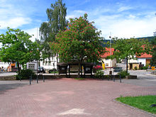
The town hall was built between 1967 and 1969. Today it houses a youth room and the “Buch-Treff”, a library, and is used by local associations or groups for smaller events. The fire station was built right next to it in 1988. After the municipality bought an agricultural property and demolished the buildings, the village square in the center of the village was completed in 1987.
The "Eßweiler" weather station of Meteomedia has been located on the site of the circular waste dump on the Schneeweiderhof since 2005 . In addition, a solar park with an output of 1.5 MW was put into operation in November 2008 on an area of four hectares. The operator is "Neue Energie Pfälzer Bergland GmbH", a joint venture between Pfalzwerke AG and the Kusel district. The 151 meter high Bornberg telecommunications tower is also located on the Schneeweiderhof .
Eßweiler community center
Since there was no longer any space for larger events in Eßweiler (the previously existing dance halls in the restaurants were gradually converted into apartments), planning for the construction of a village community center began in the early 1990s. Originally, it was to be built as a new building on the outskirts towards Jettenbach. An agricultural property in the center of the village, consisting of a house, courtyard and barn with stables, was offered for sale in the planning phase. The community acquired the property and the planning was directed in a new direction.
The foundation stone was laid on June 2, 1995. For the most part, the residents of Eßweiler contributed to their own efforts. The buildings were converted into a village community center. The old structure was preserved and integrated: The former residential building now houses the toilet facility, several smaller event rooms, the meeting room of the municipal council and, in the old vaulted cellar, the bar. The barn was gutted and contains the actual event room. A new building was erected in between. It contains the entrance area, an anteroom and the utility wing with kitchen, bar and storage rooms.
Personalities
Sons and daughters of the church
- Rudolph Schmitt (1900-1993), clarinetist
People who worked on site
- Hubertus Kilian (1827–1899), hiking musician, born in Jettenbach , died in Eßweiler.
- Alexander Ulrich (* 1971), member of the Bundestag, grew up in Eßweiler.
Web links
- Website of the local parish of Eßweiler
- Local community Eßweiler on the website of the Lauterecken-Wolfstein community
- Eßweiler at regionalgeschichte.net
- Brief portrait of Eßweiler ( memento from February 12, 2013 in the web archive archive.today ) on Hierzuland , SWR television
- Literature about Eßweiler in the Rhineland-Palatinate state bibliography
Individual evidence
- ↑ State Statistical Office of Rhineland-Palatinate - population status 2019, districts, communities, association communities ( help on this ).
- ^ A b State Statistical Office Rhineland-Palatinate: My village, my city. Retrieved December 24, 2019 .
- ↑ State Statistical Office Rhineland-Palatinate (ed.): Official directory of the municipalities and parts of the municipality. Status: January 2019 [ Version 2020 is available. ] . S. 153 (PDF; 3 MB).
- ^ E. Christmann: The settlement names of the Palatinate. Part 1, 2nd edition, Speyer 1968, p. 150
- ^ Regest of the Counts of Zweibrücken, adapted from Carl Pöhlmann by Anton Doll, Speyer 1962, p. 121
- ↑ a b L. Grünenwald: Documents and finds on the early history of the Palatinate. Palatina, born 1926, p. 212
- ↑ Rudi Lanzer: The remains of a Roman villa uncovered during excavations. The Rhine Palatinate, January 11, 2003
- ↑ Rothenberger / Scherer / Stab / Keddigkeit: Palatinate History Part 1, Institute for Palatinate. History and Folklore, Kaiserslautern, 2001, pp. 114/115
- ↑ M. Dolch: Hundheim am Glan. Background of a name change in the high Middle Ages. Westricher Heimatblätter, Vol. 20 (1989), p. 79
- ^ A b Daniel Hinkelmann: The knights Mülenstein von Grumbach (1318-1451) and their Springeburg castle (according to knowledge until April 1978) . Westrich Calendar 1979
- ↑ Johann Hofmann: Thorough and truthful description of the Eßweiler valley, like the same with its districts and boundaries inside and out in the same way with mountains, forests, red boars, stern, valleys, wells, weyers, brooks, rivers and also with old and new inhabited places and villages. Made in the correct geometric manner by Johann Hofmann, of the time Kellern zu Lichtenberg in 1595
- ↑ a b c d Rudi Emrich: On the history of the village of Eßweiler from the beginnings to the 20th century . In: Festschrift for the 100th anniversary of the Eßweiler Choral Society . 1990
- ^ FW Weber: Bauernmühlen on the tributaries of the Glan. Westrichkalender, 1986, p. 82
- ↑ A. Zink: Chronicle of the city of Lauterecken. 1968
- ↑ a b c d Christian Schüler-Beigang (edit.): Kreis Kusel (= cultural monuments in Rhineland-Palatinate. Monument topography Federal Republic of Germany . Volume 16 ). Wernersche Verlagsgesellschaft, Worms 1999, ISBN 3-88462-163-7 .
- ^ Emigration of the Gilcher family to North and South America by Friedrich Hüttenberger on the Internet
- ^ Michael Cappel: Forays through three church visits in the Eßweiler valley. Westrichkalender, Kusel 1989, pp. 94-99
- ^ H. Matzenbacher: Parish and school history of the city of Wolfstein . Wolfstein 1966
- ↑ a b c d e W. Schlegel, A. Zink: 150 years of the Kusel district. Otterbach / Kaiserslautern 1968
- ↑ a b "... carried away on trucks": the Jewish citizens in the city of Kusel . Alliance against right-wing extremism, Kusel 2008, DNB 991427025 .
- ↑ Commemorative Book - Victims of the Persecution of Jews under the National Socialist Tyranny in Germany 1933–1945, Federal Archives, Koblenz 1986 (email from Wiliam Gicher with excerpt)
- ↑ Joods Monument. In: Digital Monument to the Jewish Community in the Netherlands. Retrieved December 24, 2019 (Dutch).
- ^ H. Arnold: From the Jews in the Palatinate. Speyer 1967
- ↑ a b Bernhard Kukatzi: The Jewish cemetery in Hinzweiler. Landau 2008
- ↑ a b c Municipal statistics from the national system EWOISneu , via http://www.rlpdirekt.de/
- ^ The Regional Returning Officer Rhineland-Palatinate: Local elections 2019, city and municipal council elections. Retrieved December 24, 2019 .
- ^ A b Dennis Bachmann: Eßweiler municipal council meets for the first time. Die Rheinpfalz, July 9, 2019, accessed on April 29, 2020 .
- ^ The Regional Returning Officer of Rhineland-Palatinate: direct elections 2019. see Lauterecken-Wolfstein, Verbandsgemeinde, seventh line of results. Retrieved April 29, 2020 .
- ↑ Dietmar Fligg: Eßweiler: Peter Gilcher stops as local mayor at the end of the year. Die Rheinpfalz, December 20, 2016, accessed on April 29, 2020 .
- ^ A b State Statistical Office Rhineland-Palatinate: Eßweiler. Population. In: My village, my city. December 31, 2018, accessed May 23, 2020 .
- ↑ Bayr. Yearbook, calendar for Bureau, Comptoir and Haus, Munich 1893
- ↑ a b c d Westrichkalender Kusel, respective year, published by the district of Kusel
- ^ A b State Statistical Office Rhineland-Palatinate: Eßweiler. In: Census 2011. May 9, 2011, accessed May 23, 2020 .
- ^ SG Jettenbach / Eßweiler / Rothselberg. Retrieved March 25, 2019 .
- ↑ Michael Cappel: 100 years of rock mining - history and significance for the region. Westrich calendar, 2005
- ^ Rudi Lanzer: Eßweiler quarry. Westrich calendar, 1963


