Höcherbergweg
| Höcherbergweg | |
|---|---|
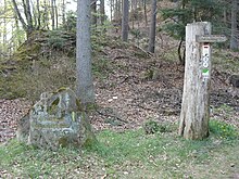
 Trail marking of the Höcherbergweg |
|
| map | |

|
|
| Data | |
| location | Saarland , Rhineland-Palatinate |
| Markers |
|
| Starting point |
Niederwürzbach 49 ° 14 '41.6 " N , 7 ° 12' 3.4" E |
| Target point |
Böchingen 49 ° 14 '19 " N , 8 ° 5' 32" E |
The Höcherbergweg is a hiking trail that runs through the east of the Saarland and the south of Rhineland-Palatinate . It is named after the Höcherberg and runs from Niederwürzbach to the Palatinate town of Zweibrücken .
Labelling
The waymarks are two horizontal bars, the lower one is white and the upper one is red.
course
The path leads from Niederwürzbach to Kirkel through the Sankt Ingbert-Kirkeler forest area . Via the Kohlhof district of Neunkirchen , the route near Niederbexbach reaches the urban area of Bexbach . Running a short distance through Bexbach, the Höcherbergweg climbs following the Feilbach valley and leads to Höchen . From here the path reaches the eponymous mountain, on which there is a hiking home of the Palatinate Forest Association. From the Höcherberg, the path continues to Waldmohr in Rhineland-Palatinate. He then crossed the state border with Saarland two more times; First it leads to the Königsbruch near the Bruchhof district of Homburg , runs below the Kehrberg, passes the Kehrberghütte hiking home and leads past the ruins of Karlsberg Castle to Kirrberg and on to Zweibrücken.
Worth seeing
The path leads past the silver sand spring shortly after Kirkel. The Saarland Mining Museum is located in Bexbach and shows, among other things, the mining history of the Höcherberg area, which you will also encounter further along the way. In Zweibrücken, the park of Europe's rose garden is worth seeing.
Continuation of the marking "red and white double line"
The marking "red-white double line" is continued as a hiking trail of the Palatinate Forest Association via the Hahnberghütte and Contwig along the southern edge of the Sickinger Höhe via the Pirmasens airfield and Maßweiler to Thaleischweiler-Fröschen . The path now leads south and enters the Palatinate Forest and its southern part Wasgau along the Blümelsbach and Felsalb . The Hohe List hiking home is passed through the hamlet of Kettrichhof , which belongs to Lemberg . It continues over the southern flank of the Great Samsberg to Fischbach bei Dahn and then over the valleys of Fischbach and Roßbach along the Great Eyberg to Dahn . The path then touches the northern edge of Erfweiler , follows the Langebach , passes Hauenstein and runs between Mischberg and Neding towards Wilgartswiesen .
There he takes a course north and enters the Frankenweide , passes the Katzenkopf and the Staufelkopf before he reaches the Hermersbergerhof . A few kilometers to the east it runs through the valley of the Kaltenbach , after which the federal road 48 crosses within the Wellbach valley . It touches the northern flank of the Almersberg , runs along the Dürrentalbach on the northern slope of the Prestenberg . Via Eusserthal and its monastery of the same name and Dernbach , he passes the Dernbacher Haus hiking inn and the Landauer Hütte . Along the Hainbach and not far from the Walddusche , the Höcherbergweg, which then exits the Palatinate Forest, first reaches Gleisweiler and finally the end point Böchingen .
From Dahn to Erfweiler and from Hauenstein to Hermersbergerhof, the marking runs together with the Pfälzer Waldpfad hiking trail .
source
- Saarland hiking map from the Saarwald Association. RV Verlag, Stuttgart, ISBN 3-575-11159-6
