
Neding
| Neding | ||
|---|---|---|
 Hauenstein with the Neding (center) |
||
| height | 336.3 m above sea level NHN | |
| location | near Hauenstein and Wilgartswiesen ; District of Südwestpfalz , Rhineland-Palatinate ( Germany ) | |
| Mountains | Wasgau ( Palatinate Forest ) | |
| Coordinates | 49 ° 11 '55 " N , 7 ° 51' 26" E | |
|
||
| Type | Back mountain | |
| rock | Buntsandstein and Zechstein rock units | |
| Age of the rock | 251–243 million years (red sandstone) , 256–251 million years (Zechstein) |
|
| particularities | Bizarre rock formations; Nedingfelsen: panoramic view, rock gate | |

The Neding near Hauenstein in the Rhineland-Palatinate district of Südwestpfalz is 336.3 m above sea level. NHN high mountain in the northern Wasgau in the Palatinate Forest . On the ridge mountain there are numerous rock formations of the Buntsandstein , such as the Nedingfelsen with a rock gate.
Geographical location
The Neding is located in the Palatinate Forest Nature Park in the northern part of the Dahner Felsenland and Wasgauer Felsenland. A part of the district boundary of the municipalities of Hauenstein, which lies directly south of the mountain, and Wilgartswiesen, which is around 1.5 km (as the crow flies ) northeast of its summit, runs over the mountain and its summit . The Neding runs for about 1250 m from the eastern Queich valley to the mountain saddle to the western Mischberg ( 324 m ).
Rocks and views
In the summit region of the Neding there is a band of rocks with distinct individual formations. The so-called rock gate is particularly well-known . On the west side is the free-standing Nedingfelsen , designated as a natural monument and a maximum of 12 m high . There is a summit cross on it . From the rock plateau you have an excellent view to the south of Hauenstein and the southern Wasgau, in particular to the nearby mountains Weimersberg ( 376.1 m ), Hoher Kopf ( 442.6 m ), Benz ( 369.9 m ) and Winterberg ( 460 , 8 m ) with the imposing rock formations such as the Burgenhalderfelsen and Kreuzelfelsen, as well as the source valley of the Queich and the Gillenbach valley. In the north you can see the Schloßberg ( 336.9 m ) with the Falkenburg ruins and mountains of the Middle Palatinate Forest or the Frankenweide - such as the Great and Small Breitenberg (455.6 and 457 m ). To the west you can see the area of the south-western Palatinate Forest . A view to the east is not possible because of the Neding forest.
gallery

Nedingfelsen
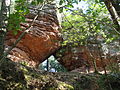
Rock gate


Traffic and walking
North past the Neding between the Hauenstein train station and Wilgartswiesen, the federal road 10 , from which the state road 495, which runs south of the mountain through Hauenstein, branches off to the west . From this in turn the district road 38 branches off in the village , which runs east past the Neding to the B 10; so you can bypass the mountain. North past the Neding, the Landau – Rohrbach railway runs parallel to the B 10, with the Hauenstein Mitte stopping point directly west-northwest of the mountain . For example, starting at these traffic axes or in Hauenstein or Wilgartswiesen, the mountain can ultimately be hiked on (marked) forest paths and paths. It is crossed by the “Hauensteiner Schusterpfad” circular hiking trail , which was certified as a premium trail by the German Hiking Institute and inaugurated in 2013.
Web links
Individual evidence
- ↑ a b LANIS: Neding. Retrieved March 9, 2017 (topographic map).
- ↑ Palatinate hiking menu: Hauensteiner Schusterpfad , accessed on October 10, 2017