Crows Mountain
| coat of arms | Germany map | |
|---|---|---|

|
Coordinates: 49 ° 20 ' N , 7 ° 28' E |
|
| Basic data | ||
| State : | Rhineland-Palatinate | |
| County : | Southwest Palatinate | |
| Association municipality : | Thaleischweiler-Wallhalben | |
| Height : | 365 m above sea level NHN | |
| Area : | 4.4 km 2 | |
| Residents: | 177 (Dec. 31, 2019) | |
| Population density : | 40 inhabitants per km 2 | |
| Postal code : | 66894 | |
| Area code : | 06337 | |
| License plate : | PS , ZW | |
| Community key : | 07 3 40 216 | |
| Association administration address: | Hauptstrasse 52 66987 Thaleischweiler-Fröschen |
|
| Website : | ||
| Local Mayor : | Thomas Martin | |
| Location of the local community Krähenberg in the district of Südwestpfalz | ||
Krähenberg is a municipality in the Südwestpfalz district in Rhineland-Palatinate . It belongs to the Thaleischweiler-Wallhalben community .
geography
Krähenberg is located on the Sickinger Höhe in the southwest of the Palatinate .
history
| Political affiliation with Krähenberg since 1648 | ||
| Country | Administrative unit | Affiliation |
|
|
Pfalz-Zweibrücken | 1648-1797 |
|
|
Department of Mont-Tonnerre | 1797-1804 |
|
|
Department of Mont-Tonnerre | 1804-1816 |
|
|
Palatinate (Bavaria) | 1816-1837 |
| Palatinate | 1837-1871 | |
|
|
Palatinate to Kingdom of Bavaria | 1871-1918 |
|
|
Palatinate to the Free State of Bavaria | 1918-1933 |
|
|
Palatinate to Bavaria | 1933-1945 |
|
|
||
| French zone of occupation | 1945-1946 | |
| Rhineland-Palatinate | 1946-1949 | |
|
|
Rhineland-Palatinate | since 1949 |
Krähenberg was created through resettlement when residents of Wiesbach moved to the heights. The place was first mentioned in 1564 under the name Newen Wiesbach am Creenborn . In 1635, Krähenberg was depopulated. From 1700 onwards settlers followed, who moved up from the damp valleys. There are several parallels to this at Sickinger Höhe. The Krähenberger district was formed around 1800. Until then, the place still belonged to Wiesbach.
On May 5, 1869, the name Krähenberg became widely known after the Krähenberger meteorite fell here . The noise of the impact was perceived as far as the Rhine plain. The meteorite is now in the Palatinate Museum for Natural History in Bad Dürkheim .
In 1920, the congregation moved from the district office Homburg for district office two bridges .
Population development
The development of the population of Krähenberg, the values from 1871 to 1987 are based on censuses:
|
|
Religions
At the end of 2014, 63.5 percent of the population were Protestant and 22.3 percent Catholic. The rest belonged to another religion or were non-denominational.
politics
Municipal council
The council in Krahenberg consists of six council members, who in the local elections on May 26, 2019 in a majority vote were elected, and the honorary mayor as chairman.
mayor
Thomas Martin is the local mayor of Krähenberg. In the direct election on May 26, 2019, he was confirmed in his office for a further five years with a share of the vote of 65.09%.
coat of arms
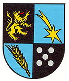
The description of the coat of arms reads: "Squared by black and blue, top right a left-facing, red-armored and tongued golden lion, top left a falling golden comet, bottom right a slanted golden spike and bottom left five silver balls 2: 1: 2."
It was approved by the Neustadt district government in 1979 .
When the coat of arms was created, there was obviously a confusion between meteorite and comet, in that the tracer of the meteorite was depicted as a comet's tail .
Sights and culture
Krähenberg has several courtyards from the Wilhelminian era and a war memorial to commemorate those who fell in the two world wars.
Economy and Infrastructure
In the past, when most households were still storing potatoes , the Krähenberg farmers were known throughout the West Palatinate for their quality products. They drove from house to house with their loaded tugs.
The L 467 runs through the village . The A 6 runs about 10 km to the north, and the A 62 at the same distance to the east .
Web links
- The local community Krähenberg on the website of the Thaleischweiler-Wallhalben community
- Literature about Krähenberg in the Rhineland-Palatinate State Bibliography
Individual evidence
- ↑ a b State Statistical Office of Rhineland-Palatinate - population status 2019, districts, municipalities, association communities ( help on this ).
- ↑ State Statistical Office Rhineland-Palatinate - regional data
- ↑ Municipal statistics KommWis, as of December 31, 2014
- ^ The Regional Returning Officer Rhineland-Palatinate: Local elections 2019, city and municipal council elections.
- ^ The Regional Returning Officer of Rhineland-Palatinate: direct elections 2019. see Thaleischweiler-Fröschen-Wallhalben, Verbandsgemeinde, 13th line of results. Retrieved March 28, 2020 .
- ^ Karl Heinz Debus: The great book of arms of the Palatinate . Neustadt an der Weinstrasse 1988, ISBN 3-9801574-2-3 .


