Knopp-Labach
| coat of arms | Germany map | |
|---|---|---|

|
Coordinates: 49 ° 20 ' N , 7 ° 30' E |
|
| Basic data | ||
| State : | Rhineland-Palatinate | |
| County : | Southwest Palatinate | |
| Association municipality : | Thaleischweiler-Wallhalben | |
| Height : | 385 m above sea level NHN | |
| Area : | 5.95 km 2 | |
| Residents: | 406 (Dec. 31, 2019) | |
| Population density : | 68 inhabitants per km 2 | |
| Postal code : | 66917 | |
| Area code : | 06375 | |
| License plate : | PS , ZW | |
| Community key : | 07 3 40 215 | |
| Community structure: | 2 districts | |
| Association administration address: | Hauptstrasse 52 66987 Thaleischweiler-Fröschen |
|
| Website : | ||
| Local Mayor : | Ralph Schneider | |
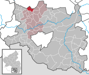
| Location of the local community Knopp-Labach in the district of Südwestpfalz | ||
Knopp-Labach is a municipality in the Südwestpfalz district in Rhineland-Palatinate . It belongs to the Thaleischweiler-Wallhalben community .
geography
Knopp-Labach is on the Sickinger Höhe . It consists of the districts Knopp and Labach (about 180 inhabitants). Knopp is a high town and Labach is idyllically situated in the valley. The districts are three kilometers apart. The difference in altitude is about 120 m.
Knopp-Labach also includes the Knoppermühle, Kreuzhof, Labachermühle and Wieselbornerhof residential areas and the Labach holiday home.
history
The place name Labach was first mentioned in a document in 1264. The place Knopp emerged later. The place was formerly part of the Landstuhl rule .
Population development
The development of the population of Knopp-Labach, the values from 1871 to 1987 are based on censuses:
|
|
Religions
At the end of 2014, 79.5 percent of the population were Catholic and 12.0 percent Protestant. The rest belonged to another religion or were non-denominational.
politics
Municipal council
The local council in Knopp-Labach consists of eight council members, who were elected by a majority vote in the local elections on May 26, 2019 , and the honorary local mayor as chairman.
mayor
Ralph Schneider became the local mayor of Knopp-Labach on July 17, 2014. Since there was no candidate in the direct election on May 26, 2019, he was re-elected by the local council on July 25, 2019. Schneider's predecessor was his uncle Emil Schneider, who held the office for 20 years.
coat of arms
|
Blazon : "In silver on a black three-mountain, in it five silver balls 2: 1: 2, on the right a green scythe and a green shepherd, crossed, on the left a rooted green tree."
It was approved by the Neustadt district government in 1973 . |
|
| Foundation of the coat of arms: The five Bollen remind of the former local lords, the Lords of Sickingen . |
Culture and sights
The district of Labach is known nationwide for its catholic parish church of the Assumption from the middle of the 14th century and the cemetery with a Gothic gatehouse from the same period.
Cemetery wall, renovated in 2015 with the support of the German Foundation for Monument Protection and the Daniel Theysohn Foundation
See also: List of cultural monuments in Knopp-Labach
Economy and Infrastructure
Knopp is shaped by agriculture. There are still two full-time businesses and several part-time businesses. Six wind turbines have been standing on Knopper Hübel, but also on the Krähenberger district, for several years. Most of the people of Labach do their work as commuters. There are still four part-time farmers who raise sheep, fallow deer and poultry.
Web links
- The local community Knopp-Labach on the website of the Verbandsgemeinde Thaleischweiler-Wallhalben
- Knopp-Labach in the show here in Germany
- Literature about Knopp-Labach in the Rhineland-Palatinate State Bibliography
Individual evidence
- ↑ State Statistical Office of Rhineland-Palatinate - population status 2019, districts, communities, association communities ( help on this ).
- ↑ State Statistical Office Rhineland-Palatinate (ed.): Official directory of the municipalities and parts of the municipality. Status: January 2018 [ Version 2020 is available. ] . S. 111 (PDF; 2.2 MB).
- ↑ State Statistical Office Rhineland-Palatinate - regional data
- ↑ Municipal statistics KommWis, as of December 31, 2014
- ^ The Regional Returning Officer Rhineland-Palatinate: Local elections 2019, city and municipal council elections
- ↑ Schneider follows Schneider. Pfälzischer Merkur, July 18, 2014, accessed on March 28, 2020 .
- ↑ The Regional Returning Officer Rhineland-Palatinate: direct elections 2019. see Thaleischweiler-Fröschen-Wallhalben, Verbandsgemeinde, twelfth line of results. Retrieved March 28, 2020 .
- ↑ Minutes of the constituent meeting of the local council of the local community Knopp-Labach. Verbandsgemeinde Thaleischweiler-Wallhalben, July 25, 2014, accessed on March 28, 2020 .
- ^ Karl Heinz Debus: The great book of arms of the Palatinate. Neustadt an der Weinstrasse 1988, ISBN 3-9801574-2-3 .
- ↑ Ludwig Petry (ed.): Handbook of the historical sites of Germany . Volume 5: Rhineland-Palatinate and Saarland (= Kröner's pocket edition . Volume 275). 3rd revised edition. Kröner, Stuttgart 1988, ISBN 3-520-27503-1 , p. 190.


