
Dorenbach
| Dorenbach | ||
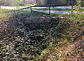
 The Dorenbach near the former Allschwiler Weiher shooting range |
||
| Data | ||
| Water code | CH : 12638 | |
| location | Canton of Basel-Country , Canton of Basel-Stadt ; Switzerland | |
| River system | Rhine | |
| Drain over | Birsig → Rhine → North Sea | |
| source | in the Allschwil forest between Oberwil , Biel-Benken and Allschwil 47 ° 31 ′ 54 ″ N , 7 ° 32 ′ 31 ″ E |
|
| Source height | approx. 337 m | |
| muzzle | near Binningen in the Birsig coordinates: 47 ° 32 '38 " N , 7 ° 34' 40" E ; CH1903: 610 482 / 265 916 47 ° 32 '38 " N , 7 ° 34' 40" O |
|
| Mouth height | approx. 266 m | |
| Height difference | approx. 71 m | |
| Bottom slope | approx. 20 ‰ | |
| length | approx. 3.6 km | |
| Catchment area | approx. 7.5 km² | |
The Dorenbach is an approximately 3.6 kilometers long tributary of the Birsig , which rises in a loess area in the Allschwil Forest between Oberwil , Biel-Benken and Allschwil, a few kilometers southwest of Basel . For the most part, it forms the cantonal border between Basel-Stadt and Basel-Landschaft , but leaves it when crossing Basel Zoo just before it flows into the Birsig. The name is said to come from the thorn bushes on the river bank.
geography
The Dorenbach rises at 337 m above sea level. M. in the Hinteren Allmend , the southernmost part of the Allschwiler Forest. After a few hundred meters it takes the Chuegrabenbach (from Oberwil ) and a little further down the Weierbach (from Binningen). At the Allschwiler Weiher the naturally flowing water leads into an artificially constructed canal from which it flows into the Birsig just before the Margarethenhügel . Its current catchment area is about 7.5 square kilometers.
- photos
Source of the Dorenbach on the connecting road between Allschwil and Oberwil

The Dorenbach at Dorenbachstrasse in the Neubad district. Border between the canton of Basel-Landschaft (right) and the canton of Basel-Stadt (left)

The Dorenbach flows into the Birsig above the Dorenbach Viaduct


History of the course of the river
The natural course of the Dorenbach originally led northwards via Allschwil to Basel. Around today's Felix-Platter-Spital it took up the creek ditch , flowed to the state border near Bourgfelden and from there to the east directly into the Rhine . Rock deposits at Steinbühl (today's Steinbühlplatz in Allschwil) and at Lysbüchel ( Basel-St. Johann ) suggest that the river regularly seeped away from its mouth during dry periods.
The Augustinian Canons' Monastery of St. Leonhard , founded in 1135, had spring water from the Dorenbach fed into the fortified city by means of dykes at the earliest since 1265 ; from this line the first Basler well works and the Schützenmattweiher (first used in 1295) was filled. In 1428 the canons had the Herrengraben built, into which the water at the outlet from the Allschwil Forest was partially diverted along the dyke line. At the latest with the construction of the Allschwiler Weiher in 1674 and the construction of an overflow ditch to the Birsig in 1677, the old course of the river was finally drained.
Around 1800 the name Dorenbach became established for the overflow canal previously known as Holeegraben (and thus for the entire new course of the river). With the construction of pipelines beginning in 1824, the Herrengraben was gradually leveled after 1864. In 1899 and 1940 the Dorenbach was extensively renovated; An extensive renaturation followed from 1991 to 1995 .
Others
Located just off the mouth of the Dorenbachs in Birsig is located Dorenbachviadukt .
Dorenbach is also the name of a patrician country estate in Lucerne, where, towards the end of the Second World War, important negotiations took place that led to the armistice in northern Italy, Operation Sunrise .
literature
- Hansjörg Huck: Dorenbach . In: Before the then Steinin-Crüz-Thor. Basel 2006.
- André Salvisberg : The Basel street names. Christoph Merian Verlag, Basel 1999.
Individual evidence
- ↑ a b c d Geoserver of the Swiss Federal Administration ( information )