Ban (Palatinate)
| coat of arms | Germany map | |
|---|---|---|

|
Coordinates: 49 ° 23 ' N , 7 ° 37' E |
|
| Basic data | ||
| State : | Rhineland-Palatinate | |
| County : | Kaiserslautern | |
| Association municipality : | Landstuhl | |
| Height : | 362 m above sea level NHN | |
| Area : | 12.94 km 2 | |
| Residents: | 2233 (Dec. 31, 2019) | |
| Population density : | 173 inhabitants per km 2 | |
| Postal code : | 66851 | |
| Area code : | 06371 | |
| License plate : | KL | |
| Community key : | 07 3 35 002 | |
| Association administration address: | Kaiserstraße 49 66849 Landstuhl |
|
| Website : | ||
| Local Mayor : | Stephan Mees ( CDU ) | |
| Location of the local community Bann in the district of Kaiserslautern | ||
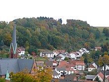
Bann is a municipality in the Kaiserslautern district in Rhineland-Palatinate . It belongs to the Landstuhl Association , within which it is the fourth largest in terms of area and the fifth largest in terms of population.
geography
location
Bann is located on the western edge of the Palatinate Forest , which merges into the Sickinger Höhe in this area , 13 kilometers southwest of Kaiserslautern in the Steinalbtal. The north of the district is part of the Sickinger stage natural area . The community also includes the Forsthaus Steigerhof residential area . In the east of the municipality is the Walkmühltal and directly on the eastern boundary of the municipality is the Kolbental . Neighboring communities are - clockwise - Kindsbach , Kaiserslautern, Queidersbach , Obernheim-Kirchenarnbach , Oberarnbach and Landstuhl .
Surveys
In the east of the district, the 471 m above sea level extends . NHN high large local mountain . The high Kahlenberg ( 461 m above sea level ) with its eastern rise, Ziegelsteige, extends to the north-east of the 375 m above sea level on the border with Landstuhl and Oberarnbach . NHN high small mountain .
Waters
A small stream, the Queidersbach , popularly known as the Steinalb , flows through Bann . It rises on the Ziegelsteige on the Sickinger Höhe, but is initially run underground and only comes to the surface in the Banner settlement area. In the east of the district the Hoheneckermühlbach rises , which in places forms the boundary to Queidersbach. Both waters belong to the river system of the moss ointment .
history
Bann was first mentioned in a document in 1182.
Until the end of the 18th century, the village of Bann belonged to the so-called Grand Court of the Landstuhl Lordship , which was owned by the Barons von Sickingen of the Hohenburg line.
In 1794 the left bank of the Rhine was occupied in the First Coalition War. From 1798 to 1814, when the Palatinate was part of the French Republic (until 1804) and then part of the Napoleonic Empire , Bann was incorporated into the canton of Landstuhl in the Donnersberg department and was subordinate to the Mairie Landstuhl .
Due to the agreements made at the Congress of Vienna , the area first came to Austria in June 1815 and was ceded to the Kingdom of Bavaria in 1816 on the basis of a state treaty . Under the Bavarian administration, Bann belonged to the Land Commissioner Homburg in the Rhine District from 1817 , and from 1862 to the Homburg District Office. Since part of the district office - including Homburg itself - was added to the newly created Saar area in 1920 , the place moved to the district office of Kaiserslautern and was administered by a district office branch located in Landstuhl until 1938.
The community has been part of the Kaiserslautern district since 1939 . After the Second World War , Bann became part of the then newly formed state of Rhineland-Palatinate and the administrative district of Palatinate within the French occupation zone . In the course of the first Rhineland-Palatinate administrative reform , the place was incorporated into the newly created community of Landstuhl in 1972 .
population
Population development
The development of the population of the municipality of Bann, the values from 1871 to 1987 are based on censuses:
|
|
religion
The Catholics belong to the Diocese of Speyer and are subordinate to the Dean's Office in Kaiserslautern , the Evangelicals to the Protestant Church of the Palatinate . The place is mainly Catholic.
politics
Municipal council
The municipal council in Bann consists of 16 council members, who were elected in the local elections on May 26, 2019 in a personalized proportional representation, and the honorary local mayor as chairman.
The distribution of seats in the municipal council:
| choice | SPD | CDU | FWG | total |
|---|---|---|---|---|
| 2019 | - | 10 | 6th | 16 seats |
| 2014 | - | 11 | 5 | 16 seats |
| 2009 | 4th | 10 | 2 | 16 seats |
| 2004 | 3 | 10 | 3 | 16 seats |
| 1999 | 4th | 9 | 3 | 16 seats |
- FWG = Free Voting Group Bann e. V.
mayor
Local mayor of Bann is Stephan Mees from the CDU. In the direct election on May 26, 2019, he was re-elected with 85.75 percent of the vote. His predecessor was his party colleague Arnold Germann, who held office until 2014.
coat of arms
| Blazon : "Split by red and black, on the right a blue-armored and tongued silver lion turned to the left, on the left five silver balls 2: 1: 2." | |
| Explanation of the coat of arms: The Bollen refer to the former membership of the Barons of Sickingen . |
Parish partnership
A partnership with the French Migné-Auxances has existed since 1989 .
Culture and sights
Cultural monuments
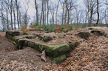
There are a total of nine objects on site that are under monument protection , including the ruin of Perlenberg Castle in the east of the district and a menhir .
nature
The nature reserve valleys and siltation zone on the Gelterswoog is partly in the area of Bann. The part of the municipal park east of the Queidersbach is part of the Palatinate Forest Nature Park , which in turn belongs to the Palatinate Forest-Vosges du Nord Biosphere Reserve . The grass flower apple variety originally comes from the Bann area, among others. In the north-east of the municipality, the Perlenberg is a natural forest reserve that was designated in 1994 and covers twelve hectares. There is also another menhir in the municipality .
Sports
The chess club SC Bann played in the first Bundesliga chess league in the 2006/07 season . The Bännjer Schützenverein, St. Hubertus Bann, is known far beyond the local borders. Almost every year the club is represented at the German Shooting Championships. The SV Bann offers football.
Events
On the fourth weekend in September, the annual church consecration and the traditional Worschtzippelfest, which is carried out by the local associations and forms the village festival, take place in Bann.
Economy and Infrastructure
economy
Due to the geographic conditions, the forest and timber industry dominated the area for centuries. The local forest areas are subordinate to the Kaiserslautern Forestry Office , as is the Steigerhof forest house in the northeastern municipality .
traffic
Bann is on Landesstraße 363, which runs from Landstuhl to Steinalben in a north-south direction . On site, the district road 61 branches off from this to Oberarnbach. The community is connected to the motorway network by the A 62 in the form of the Bann junction; south of the latter, however, it is only expanded to two lanes and thus in fact only a motor road.
The public transport is in the since 2006 transport association Rhein-Neckar integrated (VRN), before that was the community since 2000 part of the West Palatinate Transport Association (WVV). There is also the N4 night bus operated by SWK Stadtwerke Kaiserslautern Verkehrs-AG , which also leads to Queidersbach and Hohenecken .
tourism
Bann is on the north route of the Palatinate Way of St. James . The Sickinger Mühlenradweg , which connects to Thaleischweiler-Fröschen and Ramstein-Miesenbach , runs right through the settlement area . The Franconian-Hesse-Kurpfalz long-distance hiking trail, marked with a red cross, runs through the north and east of the district and the path that is part of the so-called Saar-Rhine hiking trails is marked with a black point on a white bar . The Schweinstal Sculpture Trail runs through the south of the municipality and forms part of the Rhineland-Palatinate Sculpture Trail ; along his route is the sculpture Schleierwerk by Daniel Stern, which he created in 2013.
education
The so-called Don Bosco primary school exists on site.
Personalities
Sons and daughters of the church
- Elmar Wolf (1939–2006), musician, composer, orchestra leader, music publisher and producer
- Leo Spielberger (* 1961), soccer player
People who worked on site
- Jakob Knauber (1869–1950), priest of the Diocese of Speyer, prelate, study professor and local writer, was pastor in the parish from 1907 to 1913
- Jean Zimmer (* 1993), played football at SV Bann in his youth until 2004
Web links
- Official website of Bann
- Unofficial website about spell
- Local community ban on the Landstuhl Association website
- Literature about ban in the Rhineland-Palatinate state bibliography
Individual evidence
- ↑ State Statistical Office of Rhineland-Palatinate - population status 2019, districts, communities, association communities ( help on this ).
- ↑ State Statistical Office Rhineland-Palatinate (ed.): Official directory of the municipalities and parts of the municipality. Status: January 2019 [ Version 2020 is available. ] . S. 150 (PDF; 3 MB).
- ↑ State Statistical Office Rhineland-Palatinate: Regional data.
- ↑ The Regional Returning Officer Rhineland-Palatinate: Municipal council election 2019 ban. Retrieved November 1, 2019 .
- ^ The Regional Returning Officer Rhineland-Palatinate: Municipal council election 2014 ban. Retrieved November 1, 2019 .
- ^ The State Returning Officer Rhineland-Palatinate: direct elections 2019. see Landstuhl, Verbandsgemeinde, second line of results. Retrieved November 1, 2019 .


