
Floßbach (Eckbach)
|
Floßbach Oberlauf: (Grünstädter / Grünstadter) Landgraben |
||
 2009 immediately after the renaturation: |
||
| Data | ||
| Water code | DE : 239166 | |
| location | Germany | |
| River system | Rhine | |
| Drain over | Eckbach → Rhine → North Sea | |
| confluence | from Stadtbach to Landgraben in the east of Grünstadt 49 ° 33 ′ 52 ″ N , 8 ° 10 ′ 8 ″ E |
|
| Source height | 164 m above sea level NHN at the confluence | |
| muzzle | in Dirmstein from the left in den Eckbach coordinates: 49 ° 33 '44 " N , 8 ° 15' 46" E 49 ° 33 '44 " N , 8 ° 15' 46" E |
|
| Mouth height | 100 m above sea level NHN | |
| Height difference | 64 m | |
| Bottom slope | 7.9 ‰ | |
| length | from the confluence 8.1 km | |
| Catchment area | 18.764 km² | |
| Left tributaries | Brook from a hill near the German Wine Route | |
| Right tributaries | Sausenheimer Graben | |
| Reservoirs flowed through | three retention basins on the lower reaches for heavy rainfall | |
| Small towns | Grünstadt | |
| Communities | Obersülzen , Dirmstein | |
| Residents in the catchment area | 16,800 | |
The Floßbach , on the upper reaches Landgraben there to distinguish them from waters that name sometimes green city dwellers or Grünstadter Landgraben called, is a 8.1 km long stream and a left tributary of the Eckbachs in the northern Vorderpfalz ( Rheinland-Pfalz ). The brook runs entirely on the boundaries of the city of Grünstadt and the two local communities Obersülzen and Dirmstein, which are part of the Leiningerland community .
Surname
The name of the body of water indicates that in the past it was used for the drift of logs , which were transported from the north-eastern Palatinate Forest to the poorly forested Rhine plain for heating purposes. In the region there are three other streams of the same name: also in the Vorderpfalz the Floßbach , a tributary of the Speyerbach within the urban area of Neustadt on the Wine Route , and Floßbach that from Rehbach is derived and the Isenach flows, and in the West Palatinate the Floßbach , which flows into the Mohrbach .
geography
course
The Floßbach does not arise from a single source , but flows east of the train station in Grünstadt from several source brooks, all of which arise on the slopes of the upper urban area and are called ditches . One of them is above all the watercourse running above ground from Luitpoldplatz to the train station, which is popularly known as Jägergraben or Jägerbächel . Most of the other upper courses, on the other hand, are underground in the inner city or have fallen dry; they are no longer recorded in the current official cartography. However, their names can be found in field names or street names such as Auf dem Bleichgraben or Am Wassergraben .
The water of the trenches collects east of the residential buildings in Grünstadt and the railway line in the area of the sewage treatment plant and flows together at a height of 164 m to form the Landgraben . The city's treated wastewater is also discharged into these before the stream flows east to the municipality of Obersülzen. From the street village flows from the right water only periodically leading Sausenheimer trench , then left a further temporarily dry falling stream, the north west of Obersülzen at a vine hill of the lower Haardt in about 150 m springs height.
- Floßbach north of Dirmstein

Sometimes deeply cut ...

... sometimes sluggish and peaceful ...

... and sometimes foaming white


The now called Floßbach flows along the southern slope of an elongated, low ridge that protrudes from the west into the Rhine plain and to which the Wörschberg ( 165 m ) and the Schneckenberg ( 143 m ) belong. The ridge is part of the watershed between the catchment areas of the Eckbach in the south and the Eisbach in the north. After 4 km the Floßbach reaches the Dirmstein district. Its brook bed falls on this route by about 40 m to the Rhine plain. In the course of time it has sometimes buried itself several meters deep in the local loess layers . Along the southern slope of the Stahlberg ( 134 m ), which also belongs to the local watershed, the Floßbach runs in a wide right-hand curve around Dirmstein to the south and crosses under Landesstraße 453 (Grünstadt– Frankenthal ). Below the former Niedermühle and southeast of the development area overnight Gardens opens it to 100 m height from the left in the Eckbach.
Tributaries
- Sausenheimer Graben ( right ), 4.1 km, 6.9 km²
nature and environment
Renaturation
Upper course
In the years from 2006 to 2008 the brook was renatured first on the Grünstadt and Obersülzer districts over a distance of 3.1 km . The old brook profile was preserved at 650 m; 1100 m were widened and changed on one side, and a completely new water bed was created at 1350 m. Flat marginal strips up to 30 m wide were created on both sides of the water. As a result, the flow speed decreased, oxbow lakes, meanders and islands formed. The renaturation of this section was officially completed on August 14, 2008 by the then Environment Minister of Rhineland-Palatinate, Margit Conrad .
Lower course

The building area north of Heuchelheimer Strasse in the northeast of Dirmstein , located in a depression on the lower reaches, suffered even more intensely than the area on the upper reaches from large-scale flooding; for the first time at the end of June 1994, four cellars were under water up to the top. After many years of discussion, during which there were further, albeit smaller, floods, various plan variants for renaturing the stream and creating flood plains were presented in 2006. In 2008, the council of the then Verbandsgemeinde Grünstadt-Land decided to renaturalize the water over a distance of over 1 km. The measure, which was classified as ecologically valuable, was subsidized by the state of Rhineland-Palatinate as part of the Blue Campaign with 90% of the costs, 10% had to be borne by the municipality.
During the work, which began in October 2008, former arable land was first removed along the stream, which had become the property of the municipality during the previous land consolidation ; this made it possible to flatten the previously steep banks. Then three new ponds were created as reservoirs , into which the water can spread laterally in the event of future heavy rainfall. The two upper ones hold 3500 m³ and 5500 m³ of water. Because their respective drains have different cross-sections (at the upper reservoir 80, at the lower 90 cm), they act as real retention basins that can release more water downwards than flows in from above. The first pond is in a so-called " millennium rain out of hand" on the adjacent farmland, for so enlarged lake in turn serves a specially defined higher Wirtschaftsweg as dam . The third pond shortly before crossing under the state road 453 is able to achieve an even better functionality if the drainage provided with a kink under the state road is straightened.
- Floßbach in winter

Floßbach below the middle retention basin

Middle retention basin from the southwest

Middle retention basin from the north

Floßbach in Dirmstein above the lower retention basin


In order to reduce the flow speed of the raft stream, meanders were created and the straight water flow was blocked with large stones. In particular, however, two almost right-angled bends in the run were eliminated by creating a wide curved arch at the first point and the top of the three retention basins at the second. After planting trees and shrubs typical of the site, the renaturation was completed in spring 2009. On May 26th of the same year, the newly designed section of the stream was inaugurated by Sabine Röhl , the then district administrator of the Bad Dürkheim district ; in a heavy rain the week before, the change had already proven its worth.
biology

"Insect villa " made by the Alte Sandkaut environmental association
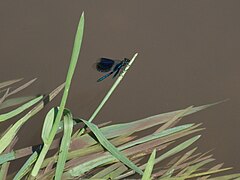
Banded demoiselle (Calopteryx splendens) at the raft stream


fauna
Mallards , gray herons and a pair of marsh harriers were the first larger birds to accept the renovation work on the lower reaches in 2009. During the following summer also increasingly typical aquatic insects such as were Great Emperor Dragonfly , the banded demoiselle , the diving beetle and the Big Piston water beetles and various types of frogs and tailed amphibians found. The frogs were grass and Teichfrosch be safely identified in tailed amphibians, the common newt . 2012 brooded first time a dipper under the Floßbach bridges. Eurasian jays and long-eared owls have also been observed since 2013 . The dipper was reported again in 2014.
flora
In the past, the lower reaches of the three retention basins were lined with poplar , birch , willow , sloes and cherry plums ; such trees continue to thrive. Even some oleanders that "escaped" from gardens were able to settle and, thanks to the favorable microclimate , which offers balanced temperatures and sufficient moisture due to the watercourse, have reached a height of 6 m. Of the poplars that came from the mid-20th century, only one was left in 2019. Alders , wild cherries , crab apples as well as various dogwood and snowball species have now been added through planting or seedlings .
history
Burial ground
In Dirmstein there was a burial ground to the right of the Floßbach and north of its mouth - today this is the area of the entrance to the town from Heuchelheim - in Franconian times (6th century) a burial ground that was archaeologically examined in the 1980s . The recovered artifacts were to Speyer to the Historical Museum of the Palatinate spent. Some of the experts dealing with the finds even hold the opinion that the tombs were at least partially in use as early as the Alemannic period (5th century).
Lindesheim
On the Raftbach between Obersülzen and Dirmstein on the southeast slope of the Wörschberg was the small village of Lindesheim , which was abandoned by its residents in the Middle Ages around 1350; There are no more traces of the desert , at least above ground. The saga of the history of the Dirmsteiner bells deals with the submerged village that Lindesheimer Straße on the north-western edge of Dirmstein is reminiscent of .
Straightening
In the second half of the 20th century, the Floßbach was straightened to the Dirmstein district . In order to obtain rectangular arable land, two sharp bends were built into the lower reaches. As a result of the straightening, the already high flow velocity increased even further. This because even flooding space was lost, in some places the rose on the running flood risk during heavy rainfalls.
literature
- Walter Lampert: 1100 years of Grünstadt . A home book. City administration Grünstadt, Grünstadt 1975.
Web links
- Course of the Floßbach on: OpenStreetMap
- Middle retention basin ( 104 m ) at the Floßbach-Unterlauf on: Map service of the landscape information system of the Rhineland-Palatinate nature conservation administration (LANIS map) ( notes )
Individual evidence
- ↑ Topographic map No. 6414, 1: 25,000.
- ↑ Topographic map No. 6415, 1: 25,000.
- ↑ a b Rhineland-Palatinate Water Management Authority .
- ↑ Landgraben - renaturation near Dirmstein. State Office for the Environment, Water Management and Trade Inspection Rhineland-Palatinate, May 26, 2009, accessed on July 7, 2015 .
- ↑ Solution found for flood in Lokalbahnstraße . In: The Rheinpfalz , Frankenthaler Zeitung . Ludwigshafen April 26, 2008.
- ↑ "Playground" for flood protection . In: The Rheinpfalz , Frankenthaler Zeitung . Ludwigshafen May 26, 2009.
- ↑ a b c Several telephone calls from a resident to user C47 as well as uploaded photos of the resident (e.g. banded demoiselle ).
- ^ Klaus Petermann: Dipper . In: Umweltverein Alte Sandkaut Dirmstein e. V. (Ed.): Rundmail . Dirmstein May 29, 2012 (photos by Lothar Kern).
- ^ Albert H. Keil: State of the "old sand chew" . E-mail to several recipients, including the local community of Dirmstein, various nature and environmental conservationists and C47 . Dirmstein September 23, 2014.
- ↑ a b Joachim Kauppert, Melanie Lebschy: The Merovingian cemetery of Dirmstein from an anthropological point of view . In: Michael Martin (ed.): Dirmstein - nobility, farmers and citizens . Chronicle of the Dirmstein community. Self-published by the Foundation for the Promotion of Palatinate Historical Research , Neustadt an der Weinstrasse 2005, ISBN 3-9808304-6-2 , p. 25-35 .
- ↑ Oskar Bischoff and others: How Susann came to the Dirmsteiner church tower . In: Pfälzischer Verkehrsverband e. V. (Ed.): The great Palatinate Book . Pfälzische Verlagsanstalt, Neustadt an der Weinstrasse 1959, p. 243 .
- ↑ a b The right-angled kinks removed in 2008/2009 (at 106.2 m and 105.5 m high) are still shown in 2020.