
Helmbach (Speyerbach)
| Helmbach | ||
 The Helmbach between Helmbachweiher and the sawmill on the L 499 |
||
| Data | ||
| Water code | DE : 23782 | |
| location |
Palatinate Forest
|
|
| River system | Rhine | |
| Drain over | Speyerbach → Rhine → North Sea | |
| source | of the Teufelsbach near the Taubensuhl forest house 49 ° 17 ′ 40 ″ N , 7 ° 54 ′ 4 ″ E |
|
| Source height | approx. 381 m above sea level NHN | |
| muzzle | at the hamlet of Helmbach from the right in the Speyerbach Coordinates: 49 ° 20 '36 " N , 7 ° 59' 9" E 49 ° 20 '36 " N , 7 ° 59' 9" E |
|
| Mouth height | approx. 201 m above sea level NHN | |
| Height difference | approx. 180 m | |
| Bottom slope | approx. 16 ‰ | |
| length | 11.1 km | |
| Catchment area | 53.569 km² | |
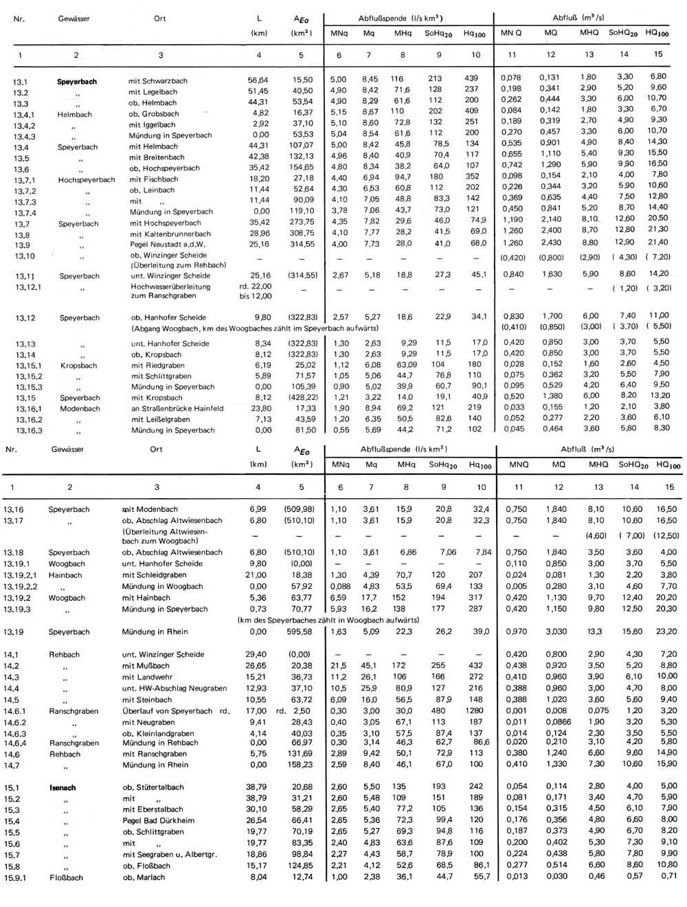
| Outflow A Eo : 53.57 km² at the mouth |
MNQ MQ Mq MHQ |
270 l / s 457 l / s 8.5 l / (s km²) 3.3 m³ / s |
| Left tributaries | Blattbach , Iggelbach | |
| Right tributaries | Grobsbach , Kohlbach | |
| Medium-sized cities | Forest demarcation of Landau in the Palatinate | |
| Communities | Districts of Elmstein , Kirrweiler forest area | |
The Helmbach is a nearly 7 and together with its main source Teufelsbach a good 11 km long brook in the Palatinate Forest ( Rhineland-Palatinate ) and a right tributary of the Speyerbach .
geography
Spring streams
The Helmbach arises from the confluence of the Teufelsbach and Blattbach near Geiswies west of the Hofberg ( 371.2 m above sea level )
Teufelsbach
The Teufelsbach , also called Geisbach on the Unterlauf , is the 4.2 km long southwest and right source brook, which rises in the forest area of the city of Landau . Some also regard it as the upper reaches of the Helmbach.
It rises at a height of 381 m a good 1 km northwest of the Taubensuhl forest house ( ⊙ ) in a mixed forest in the Teufelstal district of the Landau city forest .
The Teufelsbach initially flows almost to the west and is fed by a forest stream almost 100 m downstream on its left side. The Teufelsbach turns to the northwest and squeezes through a narrow valley. After about 350 m the stream from the Kesselbrunnenteich flows towards it from the same side . The Teufelsbach now runs in a north-northeast direction at the eastern foot of the Jägerhügel ( 497.8 m , also known as Jägerhübel ), which is overgrown with oaks and beeches , through the narrow Teufelstal . After about 1 km, the dry pond stream flows towards it again from the west and to the left .
The Teufelsbach then runs about 2.5 km northeast through a Kerbtal overgrown with mixed forest between the 479.5 m high Miederberg on its left and the Erdbirnkopf ( 506 m ) and then the Geiskopf ( 467.3 m ) on the right.
At the Geiswies and the camping site Biosphärenerlebniscamp Geiswiese to the left of the Teufelsbach, a short side arm branches off to the right, which feeds a bathing lake about 70 × 20 m in size. 120 m below, the Teufelsbach joins at a height of 270 m with the Blattbach flowing from the west-northwest to form the Helmbach .
Tributaries
- Waldbächel ( left ), 0.3 km, 1.54 km²
- (Bach vom) Kesselbrunnenteich ( left ), 0.7 km, 1.11 km²
- Dry pond stream ( left ), 1.5 km, 2.28 km²
- Muldenbach ( left ), 0.2 km, 0.27 km²
Blattbach
The Blattbach is the 3.1 km long west-northwest and left source creek. Some also consider it to be the tributary of the Heimbach.
The Blattbach rises on the northern slope of the 551 m high Blattberg and finally unites with the Teufelsbach coming from the southwest to form the Helmbach.
course
The Helmbach, which is part of the municipality of Elmstein ( Bad Dürkheim district ), moves in an east-northeast direction. After 2 km he passes the Waldhotel Hornesselwiese . This burnt down in November 2002 and - after reconstruction in 2010 - was reopened as a forest tavern in January 2011. There the Grobsbach flows from the right , 2.5 km further from the left the Iggelbach . After a total of 10 km, the Helmbach reaches the forester's house Helmbach . The Kohlbach flows here from the right , the damming of which just before the mouth was called the “ Helmbachweiher ”.
The Helmbach itself flows into the Speyerbach from the right at the hamlet of the same name . There is a stop of the Kuckucksbähnel museum railway . The estuary lies on the Kirrweiler forest area and thus in the Southern Wine Route district .
Tributaries
- Blattbach ( left source stream ), 3.1 km, 7.15 km²
- Teufelsbach ( right source stream ), 4.2 km, 9.67 km²
- Grobsbach ( right ), 4.3 km, 7.51 km²
- Hunzelbach ( right ), 1.5 km, 0.88 km²
- Frechenbach ( right ), 0.6 km, 2.56 km²
- Iggelbach ( left ), 5.1 km, 5.83 km²
- Kohlbach ( right ), 5.0 km, 14.34 km²
Characteristic
The morphologically clearly delimited catchment area of the Helmbach includes around a dozen tributaries that drain part of the Palatinate Forest via the Helmbach. A ring of ridges stretches around the catchment area: in the east the back of the Haardt with the Steigerkopf , in the south a ridge at 450 to 500 m high, which extends from the Forsthaus Heldenstein to the Forsthaus Taubensuhl. From there on the western edge a plateau extends to the 609 m high Eschkopf , while in the north a ridge with the 571 m high Schindhübel forms the watershed to the Speyerbach catchment area.
Characteristic for this part of the Palatinate Forest are deeply cut valley valleys , dense forests and the lack of settlements; The only place in the entire catchment area is the Elmstein district of Iggelbach on the upper reaches of the stream of the same name. The southern tributaries of the Helmbach mainly drain districts that politically belong to communities in the Rhine valley or on the Weinstrasse . So z. B. the upper reaches of the Helmbach itself up to the Geisweise on the forest area of the city of Landau .
Sections of the Helmbach were straightened and expanded as early as the 18th century in order to make them usable for the wood drift .
The Helmbach is one of the fine-material, silicate low mountain range brooks. The water structure quality is predominantly changed with moderate to strong, the water quality is indicated as unpolluted.
Individual evidence
- ↑ a b Topographic map 1: 25,000.
- ↑ a b c Rhineland Water Management Administration.
- ↑ Discharge values of the Helmbach.
- ^ Confluence of Teufelsbach and Blattbach .
- ↑ New beginning after almost nine years. Allgemeine Hotel- und Gastronomie-Zeitung, 2011/08 edition, February 19, 2011, p. 26 , accessed on April 11, 2011 .