
Porto Covo
| Porto Covo | ||||||
|---|---|---|---|---|---|---|
|
||||||
| Basic data | ||||||
| Region : | Alentejo | |||||
| Sub-region : | Alentejo Littoral | |||||
| District : | Setubal | |||||
| Concelho : | Sines | |||||
| Coordinates : | 37 ° 51 ′ N , 8 ° 48 ′ W | |||||
| Residents: | 1038 (as of June 30, 2011) | |||||
| Surface: | 50.72 km² (as of January 1, 2010) | |||||
| Population density : | 20 inhabitants per km² | |||||


Porto Covo is a municipality in the Sines district in the Alentejo Littoral in Portugal . 1038 inhabitants live on an area of 50.7 km² (as of June 30, 2011), which corresponds to a population density of 20.5 inhabitants / km². The place is in the Parque Natural do Sudoeste Alentejano e Costa Vicentina , a nature reserve that stretches along the entire southwestern Portuguese coast.
Porto Covo still has an old village center, which is animated by holidaymakers during the main holiday season. New buildings for overnight stays and private summer houses have been built around the site. Porto Covo has a tiny port for local fishing.
There are various small beaches that can be reached by stairs and are very popular with bathers in summer. In front of Porto Covo is the Ilha do Pessegueiro with an old fort.
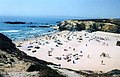
Beach in Porto Covo

Porto Covo

Surf at Porto Covo

The fort on the island


Individual evidence
- ↑ www.ine.pt - indicator resident population by place of residence and sex; Decennial in the database of the Instituto Nacional de Estatística
- ↑ Overview of code assignments from Freguesias on epp.eurostat.ec.europa.eu
Web links
- Map of the Freguesia Porto Covo at the Instituto Geográfico do Exército
