Teufelskopf (Black Forest High Forest)
| Devil head | ||
|---|---|---|
|
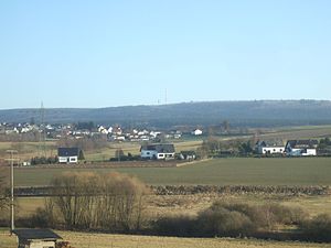
View from the northwest from the Ruwer-Hochwald-Radweg |
||
| height | 695 m above sea level NHN | |
| location | at Waldweiler ; District of Trier-Saarburg , Rhineland-Palatinate ( Germany ) | |
| Mountains | Black Forest high forest | |
| Coordinates | 49 ° 35 '53 " N , 6 ° 49' 31" E | |
|
|
||
| particularities | Teufelskopf transmitter (closed) | |
The Teufelskopf is 695 m above sea level. NHN high elevation in the wilderness, part of the Black Forest high forest ( Hunsrück ) near Waldweiler near the border between Rhineland-Palatinate and Saarland . The disused Teufelskopf transmitter is located on the elevation .
geography
location
The Teufelskopf rises in the Saar-Hunsrück Nature Park between Waldweiler in the northwest, Wadrill in the east-southeast and Steinberg in the southeast. Its summit, located in the Rhineland-Palatinate area in the Waldweiler district, is 1.7 km northeast of the Schimmelkopf ( 694.8 m ) on the border with Saarland , and 1.4 km southwest of the Mückenbornberg ( 692.6 m ). The Prims tributary Wahnbach rises on the eastern flank of the elevation . On the northwest flank lies the source of the Ruwer tributary Burkelsbach and that of its small tributary Aalbach.
Natural allocation
The Teufelskopf belongs to the natural spatial main unit group Hunsrück (No. 24), in the main unit Hoch- and Idarwald (242) and in the subunit Black Forest high forest (242.0) to the natural area Greimerather Hochwald (242.00).
Mountain height
The devil is head according to a on topographic maps recorded trigonometric point in the range of the transmitter Teufelskopf at least 695 m high. A few meters southwest of the summit is a 694.3 m high point. In the southwest of the summit region, on such maps, a 695 m contour line can be found in an oval shape with no further height information, so that it is possible that the elevation inside this oval is slightly higher than 695 m . A little east-northeast of the summit is a forest path crossing at an altitude of 685 m .
Protected areas
Parts of the nature reserve (NSG) Keller Mulde with Leh- and Rothbachtal, with Laberg and Grammert ( CDDA No. 318638; 1999 designated; 2.7168 km² ) extend to the lower areas of the northern flank of the Teufelskopf . Those of the NSG Oberes Wahnbachtal (CDDA no. 318896; 2002; 46.45 ha ), the forest landscape protection area from Saarschleife via Mettlach to Steinberg (CDDA no. 390144; 1952; 37.2597 km²) and des Fauna-flora-habitat- area Bremerkopf near Steinberg (FFH-Nr. 6407-306; 5.64 km²).
Devil's head transmitter
The disused Teufelskopf transmitter is located on the Teufelskopf . Its 120 m high and guyed transmission mast , built in 1962, has two platforms with directional antennae . The television station was switched off in 2008. Almost 100 m east-southeast of the transmission tower is a lower transmission tower that is used by Vodafone . The entire facility is fenced and cannot be entered by the public.
hike
A good way to hike the Teufelskopf is the signposted path from the direction of Weiskirchen . There is a small chapel on a hiking trail. All paths in the area are signposted and suitable for hikers and mountain bikers. Information is available from the Weiskirchen tourist information office .
Individual evidence
- ↑ a b c d Map services of the Federal Agency for Nature Conservation ( information )
- ↑ a b c Map service of the landscape information system of the Rhineland-Palatinate nature conservation administration (LANIS map) ( notes )
- ↑ Teufelskopf… , from April 15, 2016, accessed on September 23, 2016, on amateurfunk-blog.de

