
Maifeld cycle path
| Maifeld cycle path | |||
|---|---|---|---|
|
|
|||
| overall length | approx. 28 km | ||
| location |
|
||
| map | |||
| Link on map ( Memento from June 22, 2013 in the Internet Archive ) | |||
| Starting point | Mayen | ||
| Target point | A: Ochtendung , B: Münstermaifeld |
||
| Places along the way |
Hausen , Nettesürsch , Polch / A: Kerben , Ochtendung B: Mertloch , Naunheim , Münstermaifeld |
||
| Flooring | asphalted | ||
| Height difference | Mayen 280 m , Polch 220 m , Ochtendung 220 m , Münstermaifeld 210 m Mayen-Münstermaifeld: approx. 250 m up / approx. 225 m down |
||
| difficulty | almost level railway cycle path. | ||
| Traffic volume | exclusively bike path | ||
| Connection to | Vulkanpark-Radweg , Rhein-Mosel-Eifel-Radweg | ||
| Website URL | eifel.info | ||
The Maifeld Cycle Path is a cycle path over former railway lines in the so-called Eifler Maifeld . The highlights are two (in the future three) viaducts and two tunnels as well as numerous sculptures along the way. Starting in Mayen, the route forks after eight kilometers at Polch station. It then leads on the one hand towards Ochtendung train station (10 km) and on the other hand towards Münstermaifeld (11 km), where there is an approx. 9 km long connection path to Hatzenport on the Moselle . The flat, continuously paved bike path is also indicated as being particularly suitable for families with children.
Route Mayen - Ochtendung / Münstermaifeld
Characteristic
The Maifeld cycle path uses former railway lines and therefore has only slight inclines (maximum 40 m over approx. Two kilometers). The entire route is paved consistently in good quality and is therefore suitable for all types of bikes and skaters. It is also recommended as particularly suitable for families with children. The path is officially designated as a cycling and hiking trail. Rest areas are available along the entire route.
Mayen - Polch
The eight-kilometer section starts at the east train station in Mayen, which can be reached by regional train. It lies on the route of the Eifelquerbahn . This runs every hour between Andernach on the left Rhine route and Kaisersesch . The route then leads in the district of Hausen with a slight incline into the Nette valley, which is bridged with the help of an approximately 40 meter high natural stone viaduct. The route runs on the former railway line Koblenz-Lützel - Mayen Ost . Behind the viaduct over the Nette valley, it goes through the 252 m long Hausen-2 tunnel, which is followed by the Lehnener viaduct. With a length of 82 m, this only has a height of 8 m. Immediately afterwards follows the Hausen-1 tunnel with a length of 500 m. Both tunnels are illuminated. The route climbs slightly from the Nette valley and passes the village of Nettesürsch. Afterwards, the A48 motorway is crossed with a slight gradient before the cycle path junction at the former Polch train station is reached.
Polch - Bassenheim
In the direction of Ochtendung, the route follows the former Koblenz-Lützel - Mayen Ost railway for ten kilometers. After about four kilometers, the former station of Kerben is reached. In Kerben, the route connects to the Rhine-Main-Mosel cycle path. Then it goes up slightly (approx. 40 m for two kilometers) over the A48 and then with a slight downward gradient to the former train station in Ochtendung. Here a cycle sign indicates the connection to the Vulkanpark cycle path in the direction of Andernach. In June 2019, the bike path was expanded so that you can now drive as far as Bassenheim.
Polch - Münstermaifeld
In this direction the route follows the route of the former branch line Polch - Münstermaifeld for eleven kilometers . The almost flat route leads with a slight incline over the towns of Mertloch and Naunheim to the medieval town of Münstermaifeld. The city is visibly dominated by the mighty defensive towers of its minster, from which the city on the Maifeld owes its name. From here a connecting cycle path leads into the Moselle valley through the Schrumpfbach valley to Hatzenport , where it meets the Moselle cycle path after approx. 9 km .
Further planning
The railway line to Koblenz that follows in Ochtendung is listed in the overview of the large-scale cycle path network of the state of Rhineland-Palatinate (update 2003) as a planned national cycle path. For the 6 km long section Ochtendung - Bassenheim these plans could soon become reality. In mid-December 2010, the sale of this section was sealed by Deutsche Bahn . In 2014, the railway site was also released for other uses. Since then, the tracks have been removed at some level crossings (in Koblenz-Metternich and Koblenz-Rübenach). In June 2018 it was reported that construction of the extension would begin soon. The extension to Bassenheim was opened in summer 2019.
Sights, landscape and culture

Medieval city fortifications in Mayen

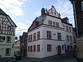
Old Town Hall Mayen

St. Clemens Mayen Catholic Church

Chapel of St. George in Polch
Münstermaifeld town hall

Holy grave sculpture in the Maifeldmünster


The Maifeld region is a hilly landscape at around 400 m above sea level. NN west of Koblenz , which is roughly bounded by the rivers Nette , Rhein, Mosel and Elz . The Maifeld is used almost exclusively for large-scale grain cultivation. Only a few large farms, which are often hidden between the rolling fields, cultivate this region. There are many well-known castles on the Maifeld, such as Burg Eltz , Burg Pyrmont , Burg Bischofstein and Burg Wernerseck .
In recent years the path has developed into a sculpture path that presents art that you can touch. The works of art represent an open-air museum in the landscape and would like to give the viewer an insight into the design possibilities of modern art. Information boards explain the individual sculptures. Many of the sculptures were created as part of the "Lapidea" symposium, which takes place regularly at Mayen. Above all, the volcanic rocks in the area such as basalt or tuff were used to give tangible expression to the imagination. Sometimes massive like the "Stier" or the "Bockspringer", sometimes playful like the "Schwingenden Pipes"
-
Mayen is located on the western edge of the Maifeld, north and southwest of the city, the Vordereifel rises in a stepped terrain. Therefore Mayen is often referred to as the "gateway to the Eifel". The river Nette flows through the city from the Eifel in the direction of Weißenthurm on the Rhine. Mayen was an important business location as early as Roman times. From the end of the 3rd century to the Middle Ages, potteries were located here, and their products were spread throughout Central Europe. Mayer's attractions include:
- The old town hall on the market square.
- The Genovevaburg from the 13th century. It houses the Eifel Museum with the German Slate Mine.
- The parish church of St. Clemens with a twisted tower. The city's landmark was rebuilt in 1947–1953 after its destruction in World War II.
- The parish church Herz-Jesu (built 1911/12).
- Parts of the city fortifications built in the 14th to 16th centuries, which enclosed the city almost in a circle with a length of 1,660 m, 4 gates and 16 wall towers.
- Reconstruction of the late Roman fortifications on the Katzenberg.
- Polch : The town was first mentioned in a document in 1052 and emerged from a former imperial estate . In the Middle Ages, Polch was protected by defensive walls and moats, but only street names are evidence of this. The Georgskapelle in the cemetery on the southern outskirts is one of the oldest churches in the Eifel. It is located away from the historical buildings of Polch on the walled cemetery with its ancient chestnut avenue. The first verifiable documentation about a church in Polch comes from a document from the year 1052.
- Ochtendung is located in a former volcanic area. The nearby extinct volcanoes Karmelenberg and Tönchesberg are evidence of volcanic activity in different periods of time. A little north of Ochtendung, Wernerseck Castle is locatedabove the valley of the Nette.
- Münstermaifeld is not far from the Moselle in the center of the front Maifeld. It is dominated by the mighty defensive towers of its minster, the former St. Martin and St. Severus . Old buildings, including the historic town hall and romantic half-timbered houses, as well as remains of the old city fortifications bear witness to the historical past. The scenic location of Münstermaifeld allows a good view of the Nürburg , the Hohe Acht , the massif on the Laacher See and far out into the Eifel and the Moselle and Hunsrück heights .

Network of cycle paths in the Maifeld
The Maifeld has a cycle path network of over 100 kilometers in length. From Polch and Münstermaifeld, but also within the route, there are numerous side routes for cycling. In Mayen, for example, the Maifeld cycle path meets the Vulkanpark cycle path . Other connections or branch lines are:
- Mayen - Monreal - Bermel
- Mayen - Maria Laach Abbey on the Laacher See
- Kerben - Braubach ( Rhine-Mosel-Eifel Cycle Route )
- Münstermaifeld - Eltz Castle
- Münstermaifeld - Pyrmont Castle - Treis-Karden (Mosel) and the Moselle cycle path
- Münstermaifeld - Hatzenport (Mosel)
see also:
Train and bus connections
The east train station in Mayen is on the Eifelquerbahn route . This runs every hour between Andernach on the left Rhine route and Kaisersesch . The RegioRadler bus route 330 (Hatzenport - Treis-Karden) runs via Münstermaifeld. The “ RegioRadler ” bus line runs daily from April 1 to October 31 and has space for 4 bicycles. Alternatively, the arrival or departure on the wheel connecting to Hatzenport (about 9 km) and from there by train on the Mosel route Koblenz - Trier possible.
literature
- ADFC regional map Eifel / Mosel , 1: 75,000. Bielefelder Verlag, 1st edition. 2006, ISBN 3-87073-391-8 .
- Bike Atlas Bike Atlas "South Eifel" - between the Ardennes and the Vulkaneifel , 1: 75,000. Verlag Esterbauer, ISBN 978-3-85000-269-1 .
Web links
- Maifeld Cycle Path: Ochtendung - Mayen with a detour Polch - Münstermaifeld , at www.achim-bartoschek.de, accessed on August 4, 2018
- Maifeld cycle path: Mayen - Ochtendung, 18 km (plus 10 km Polch - Münstermaifeld) with height profile, at www.bahntrassenradwege.de with height profile
- Info boards:
- Maifeld-Radwanderweg (PDF; 1.6 MB), accessed on August 4, 2018
- Maifeld-Radwanderweg (PDF; 1.6 MB), accessed on August 4, 2018
- Rhein-Mosel-Eifel-Radweg (PDF; 1.5 MB), accessed on August 4, 2018
- Overview map & brief portrait of the Maifeld cycle path (PDF file), from radwanderland.cms.rdts.de, accessed on August 4, 2018
- Cycle path network district Mayen-Koblenz (PDF; 2.9 MB) ( Memento from March 13, 2016 in the Internet Archive )
- Connection to RegioRadler buses in Rhineland-Palatinate
swell
- Radwanderland.de Retrieved December 2011
Individual evidence
- ↑ Maifeld cycle path can be extended , at www.wochenspiegellive.de, accessed on August 4, 2018
- ↑ Construction of the cycle path between Bassenheim and Ochtendung: work can start soon , at www.rhein-zeitung.de, accessed on August 4, 2018
- ↑ Rail line cycling, Maifeld cycle path: Bassenheim - Mayen with a detour Polch - Münstermaifeld , accessed on June 17, 2020
- ↑ Route between Ochtendung and Bassenheim approved: The cycle path is now 6.1 kilometers longer , on rhein-zeitung.de, accessed on June 19, 2020
Coordinates: 50 ° 20 '52.4 " N , 7 ° 24' 10.1" E