
Vulkanpark cycle path
| Vulkanpark cycle path | |
|---|---|
| overall length | 31 km |
| location | Maifeld , Eifel , Rhine / Rhineland-Palatinate |
| map | |
| Link on map | |
| Starting point | Mayen |
| Target point | Then after |
| Places along the way | Kottenheim , Mendig , Kruft , Plaidt , Weißenthurm |
| Flooring | mostly asphalt, water-bound surface |
| Height difference | Mayen 280 m , Andernach 56 m / approx. 120 m up / approx. 290 m down |
| difficulty | easy from Mayen to Andernach (2-6% gradient). |
| Traffic volume | Except for 2 km country road, own bike path. |
| Connection to | Rhine Cycle Path , Maifeld Cycle Path |
| Website URL | Vulkanpark-Radweg on www.eifel.info |
The Vulkanpark-Radweg is a cycle path that connects the cities of Mayen and Andernach through the Vulkanpark in the Mayen-Koblenz district. The route passes numerous volcanological and archaeological projects in the volcanic park and lets you experience 300,000 years of geological history in time lapse. Four excursions lead from the main route of the Vulkanparkradweg to attractions in the Vulkanpark. The bike route is up to around two kilometers on its own, mostly paved bike paths. It leads from Mayen to Andernach with mostly a slight, sometimes moderate gradient (2–6%). The route in this direction is also recommended for families with children. It is uniformly signposted in both directions with the bike path logo.
Route Mayen - Andernach
Characteristic
In this direction of travel mostly flat or with a slight to medium (2–6%) gradient. The route is up to about two kilometers on cycle paths and farm tracks or smaller roads, most of which are asphalted. The L120, which is driven for around two kilometers, has a traffic volume of around 1,000 vehicles in 24 hours. For about four kilometers, the route leads over paths with a water-bound surface . The start at the east train station of Mayen is at 280 m above sea level. NN and the destination Andernach at 56 m . In between, the route leads approx. 120 meters upwards and approx. 290 meters downwards. The route runs almost parallel to the Eifelquerbahn , where it is possible to get on or off at several stops. The signage is in both directions according to the guidelines of the state of Rhineland-Palatinate and marked with the cycle path logo. Due to the gradient, the route in the direction described is also recommended for families with children. The tourist highlights are the old towns of Mayen and Andernach, the volcanological and archaeological projects of the Eifel volcanic park and the cold water geyser in Andernach .
Mayen - Andernach
The Vulkanpark-Radweg starts at the east train station in Mayen, which can be reached by regional train. It lies on the route of the Eifelquerbahn . This runs every hour between Andernach on the left Rhine route and Kaisersesch . The first excursion to an attraction in the volcano park is possible in Mayen. About 0.8 km off the main route is the Mayener Grubenfeld , the oldest and formerly the most important mining site for Mayen basalt lava . On the main route, the first two kilometers are taken together with the Maifeld cycle path , before it branches off to the right before the Hausen district. After passing Kottenheim and the Thürer Wiesen you come to the junction to Mendig. A 3.2 km long excursion to the German volcano museum " Lava-Dome " and the famous lava cellars leads there . The main path continues on the L10, past the isolated Fraukirch . Then it goes right along the small meadow stream towards Kruft . After Kruft, the A 61 is crossed and the route touches the village of Kretz , where the Meurin Roman mine is located. The mine, which has been prepared for tourism as part of the volcano park, is the largest Roman underground mining area for tuff north of the Alps . It is also part of the Laacher See national geopark . The route continues to Plaidt . The information center of the volcano park is located here. From Plaidt the route follows the course of the Nette and after a few kilometers reaches the "Gut zur Nette", which belongs to the town of Weißenthurm , and the Nette confluence with the Rhine . The Zu Wied Castle can be seen on the other side of the Rhine . The last kilometers run together with the Rhine Cycle Path to Andernach, where the route ends at the "Old Krahnen" on the banks of the Rhine.
Sights, landscape and culture

Medieval city fortifications in Mayen

Old Town Hall Mayen

The nice one in Mayen

The "Lava Dome" in Mendig
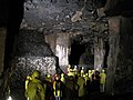
Lava cellar 32 m below Mendig
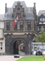
Rheintor (Kornpforte) in Andernach

Old Krahnen in Andernach
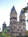
Parish Church of the Assumption of Mary in Andernach


The route leads from Mayen through the Maifeld-Pellenzer hill country , following the lower course of the river Nette into the Neuwied basin . The cycle path offers a journey through time into the “hot” history of our earth's origins. From Mayen, the center of the Volcanic East Eifel, via Mendig with its impressive rock cellars to the “Old Krahnen” in Andernach, the path connects numerous volcanological and archaeological projects in the volcanic park. Topics along the route deal with the ancient stone trade, 300,000 years of geological history in fast motion, the largest Roman tuff mine north of the Alps, underground rock cellars and much more. The cities of Mayen and Andernach impress with their historical old town and in Andernach the highest cold water geyser in the world can be visited.
-
Mayen is located on the western edge of the Maifeld, north and southwest of the city, the Vordereifel rises in a stepped terrain. Therefore Mayen is often referred to as the "gateway to the Eifel". The river Nette flows through the city from the Eifel in the direction of Weißenthurm on the Rhine. Mayen was an important business location as early as Roman times. From the end of the 3rd century to the Middle Ages, potteries were located here, and their products were spread throughout Central Europe. Mayer's attractions include:
- The old town hall on the market square.
- The Genovevaburg from the 13th century. It houses the Eifel Museum with the German Slate Mine.
- The parish church of St. Clemens with a twisted tower. The city's landmark was rebuilt in 1947–1953 after its destruction in World War II.
- Parish Church of the Sacred Heart of Jesus (built 1911/12).
- Parts of the city fortifications built in the 14th to 16th centuries, which enclosed the city almost in a circle with a length of 1,660 m, 4 gates and 16 wall towers.
- Reconstruction of the late Roman fortifications on the Katzenberg.
- Mendig : Wasfirst mentioned in a documentin 1041 as menedich . From Roman times until the 19th century, Mendig flourished thanks to the mining and processing of basaltic lava, especially as millstone and for stone. Mendiger basalt lava is still a term for a solid, durable stone. In the 19th century, the underground quarries were used as fermentation and storage cellars for 28 Mendig breweries. The "Lava Dome" museum is located in Mendig. As a central facility the volcano park it represents the geological history of the region. As grounds it makes the Lavakeller , an approximately three square kilometers of basement rocks, accessible. It was formerly the largest basalt lava mine in the world.
-
Andernach is one of the oldest cities in Germany ; in 1988 it celebrated its 2000th anniversary. Among other things, the city offers:
- The landmark of the city is the defense tower called "Round Tower" , which forms the northwest corner of the city wall.
- The "Alte Krahnen" is a stone tower crane completed in 1561 at Rhine kilometer 613.8 at the former port of Andernach.
- The Catholic parish church "Maria Himmelfahrt" , a mighty gallery basilica with four towers, western building and choir is located on the western edge of the city in direct proximity to the city wall and thus also on the western side of the Antunnacum fort , which was located there in Roman times , from which the later settlement emerged .
- The "Rheintor" was built around 1200 as the main entrance to the city from the banks of the Rhine. It is the oldest double gate in the Rhineland. Only the floor plan and parts of the lower masonry belong to the time of construction. In the 18th century, the building was rebuilt, and in 1899 it was restored to its present form, based on its appearance in the 17th century.
- Geysir Andernach , also called Namedyer Sprudel, on the Namedyer Werth (Krummenwerth), which is the highest cold water geyser in the world at around 55-60 m . The hot spring jumped for the first time in 1903 after drilling and was used commercially as a mineral spring . When closed in 1957, it was re-drilled in 2001 and has been open to the public again since 2006. The geyser was finally opened together with the geyser information center on May 30, 2009. Since then, the excursion boat called "Namedy" has been operating between the information center and Namedyer Werth in the summer months.

Connecting cycle paths
In Mayen, the Vulkanpark cycle path starts together with the Maifeld cycle path , from which the Moselle cycle path in Hatzenport is reached via Münstermaifeld through the Schrumpfbach valley (approx. 9 km) . In Weißenthurm the Vulkanpark-Radweg reaches the Rhein-Radweg and leads with it to Andernach.
Train and bus connections
The east train station in Mayen is on the Eifelquerbahn route . This runs every hour between Andernach on the left Rhine route and Kaisersesch .
The entire route of the Vulkanpark cycle path roughly follows the route of the Eifelquerbahn, so that the following train stations can be reached from the route:
- Kottenheim train station 1.7 km away (approx. 80 meters above sea level)
- Thür train station 850 m away (approx. 25 meters above sea level)
- Mendig train station 2 km away (approx. 65 meters above sea level)
- The Kruft , Kretz and Plaidt train stations are directly on the route
See also
literature
- ADFC regional map Eifel / Mosel , 1: 75,000. Bielefelder Verlag, 1st edition 2006. ISBN 3-87073-391-8
- Bike Atlas Bike Atlas "South Eifel" - between the Ardennes and the Vulkaneifel , 1: 75,000. Esterbauer publishing house. ISBN 978-3-85000-269-1
Web links
- The bike path in the volcano park
- The Vulkanpark cycle path as a PDF file
- Info boards:
- Vulkanparkradweg The cycle route (PDF; 1.6 MB)
- The white tower (PDF; 1.1 MB)
- Neuwied the dike (PDF; 1.3 MB)
- The Andernach geyser (PDF; 1.1 MB)
- Map of the Vulkanpark Cycle Path (PDF; 2.6 MB)
swell
- Radwanderland.de Retrieved December 2011
Coordinates: 50 ° 19 ′ 42.9 ″ N , 7 ° 14 ′ 24.6 ″ E