Pompey
| Pompey | ||
|---|---|---|

|
|
|
| region | Grand Est | |
| Department | Meurthe-et-Moselle | |
| Arrondissement | Nancy | |
| Canton | Val de Lorraine Sud | |
| Community association | Bassin de Pompey | |
| Coordinates | 48 ° 46 ′ N , 6 ° 8 ′ E | |
| height | 185-358 m | |
| surface | 8.13 km 2 | |
| Residents | 4,884 (January 1, 2017) | |
| Population density | 601 inhabitants / km 2 | |
| Post Code | 54340 | |
| INSEE code | 54430 | |
| Website | http://www.pompey.fr/ | |
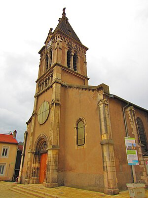
 Saint-Epvre Church |
||
Pompey is a French commune with 4884 inhabitants (as of January 1, 2017) in the Meurthe-et-Moselle department in the Grand Est region (until 2015 Lorraine ). It belongs to the Arrondissement of Nancy and the canton of Val de Lorraine Sud ( canton of Pompey until 2015 ). The inhabitants are called Pompéiens .
geography
Pompey is located north of Nancy on the Moselle River . Pompey is surrounded by the neighboring communities of Le Mercy in the north, Custines in the northeast, Frouard in the east and south and Liverdun in the west.
The former Route nationale 57 runs through the municipality . The Pompey – Nomeny railway line has been closed since 1985.
Population development
| year | 1962 | 1968 | 1975 | 1982 | 1990 | 1999 | 2006 | 2011 |
| Residents | 5,464 | 6,281 | 6,473 | 5,685 | 5,144 | 5,229 | 5,171 | 4,947 |
Attractions
- Ceramic finds from the grave field of the 2nd and 3rd centuries
- Merovingian and Alemannic necropolis from the 6th and 7th centuries
- 19th century church of Saint-Epvre
- Sainte-Anne chapel from 1633
- Saint-Euchaire chapel
Personalities
- Hubert Haenel (1942–2015), politician
- Pascal Parisot (* 1963), chansonnier
Web links
Commons : Pompey - collection of images, videos and audio files
