Tantonville
| Tantonville | ||
|---|---|---|

|
|
|
| region | Grand Est | |
| Department | Meurthe-et-Moselle | |
| Arrondissement | Nancy | |
| Canton | My au Saintois | |
| Community association | Pays du Saintois | |
| Coordinates | 48 ° 28 ' N , 6 ° 8' E | |
| height | 246-327 m | |
| surface | 8.09 km 2 | |
| Residents | 641 (January 1, 2017) | |
| Population density | 79 inhabitants / km 2 | |
| Post Code | 54116 | |
| INSEE code | 54513 | |
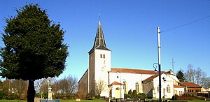
 Saint Remy Church in Tantonville |
||
Tantonville is a French commune with 641 inhabitants (as of January 1, 2017) in the Meurthe-et-Moselle department in the Grand Est region . It belongs to the Arrondissement of Nancy and the Pays du Saintois municipality .
geography
The municipality of Tantonville in Saintois is about 20 kilometers south of Nancy , between Vézelise and Haroué .
The ground relief of the 8.09 km² large municipal area west of the Madontal falls gradually from southwest to northeast. Eight kilometers south of Tantonville, in the Saintois landscape, the striking Colline de Sion with the Signal de Vaudémont tower rises 541 meters above sea level. Tantonville is located in an agriculturally intensively used area, only in the south does the community have 80 hectares of forest.
Neighboring municipalities of Tantonville are: Omelmont and Gerbécourt-et-Haplemont in the north, Affracourt in the east, Xirocourt and Praye in the south, Forcelles-Saint-Gorgon and Quevilloncourt in the west and Vézelise in the north-west.
history
Parts of the church in Tantonville date from the 14th century. The farming village experienced a great boom in 1839 when the Tourtel brothers founded a brewery here ( brasserie Tourtel ), which still exists today. In the 19th century, the Toutel brewery worked with spontaneous fermentation, among other things, and introduced numerous innovations. Louis Pasteur , after whom a street in Tantonville was named, also conducted research here from 1873 to 1874 .
Population development
The upswing through the Toutel brewery can also be seen in the population, which was over 1000 from 1881 to 1906. The population has remained largely stable since 1968.
| year | 1962 | 1968 | 1975 | 1982 | 1990 | 1999 | 2007 | 2017 | |
| Residents | 491 | 567 | 582 | 623 | 651 | 600 | 633 | 641 | |
| Sources: Cassini and INSEE | |||||||||
Economy and Infrastructure
There are eight farms in the municipality (cereal cultivation, dairy farming). Some of the residents of Tantonville live from small craft businesses or work in the local brewery. As a sideline, fruit brandies are distilled in Tantonville and the surrounding area.
Two old highways cross in Tantonville: today's Départementsstrasse 913 ( Nancy - Mirecourt ) in north-south direction and Départementsstrasse 9 ( Vézelise - Lunéville ) in west-east direction. Ten kilometers to the east, Tantonville has a connection to the motorway-like national road 57 ( Metz –Nancy– Épinal ). The Tantonville train station 1500 meters north of the town center is on the Nancy – Mirecourt – Merrey railway line .
supporting documents
- ↑ de.franceguide.com ( page no longer available , search in web archives ) Info: The link was automatically marked as defective. Please check the link according to the instructions and then remove this notice.
- ↑ Tantonville on cassini.ehess.fr
- ↑ Tantonville on insee.fr
- ↑ Farms on annuaire-mairie.fr (French)
